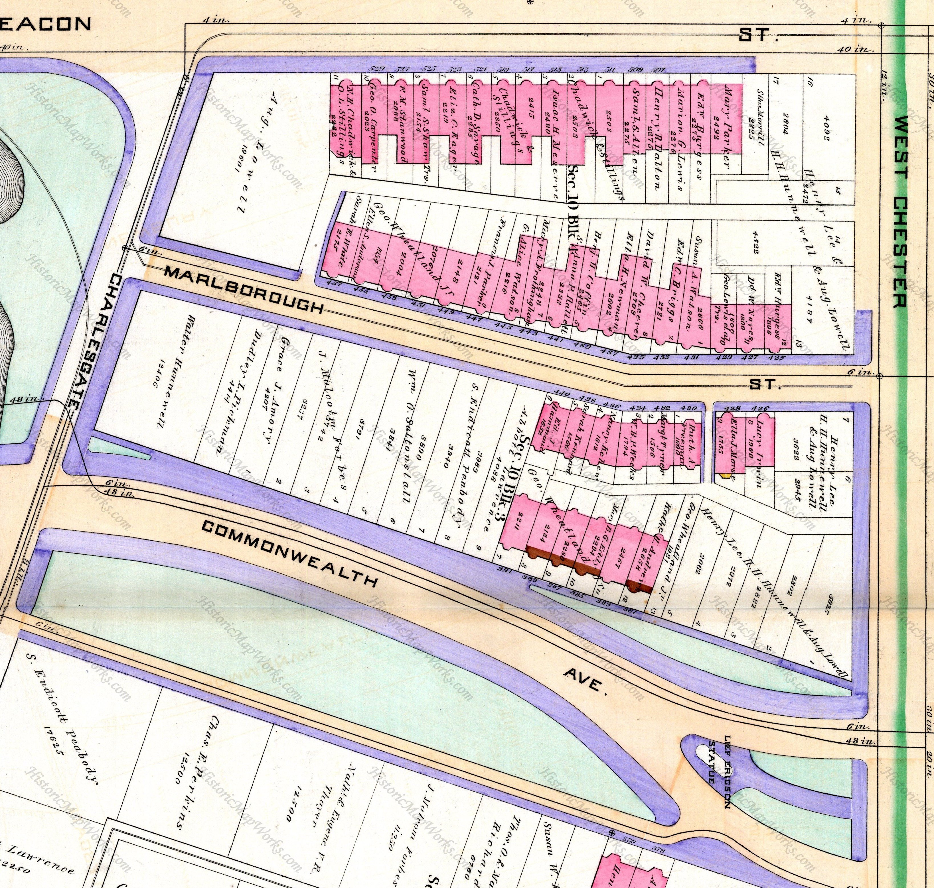
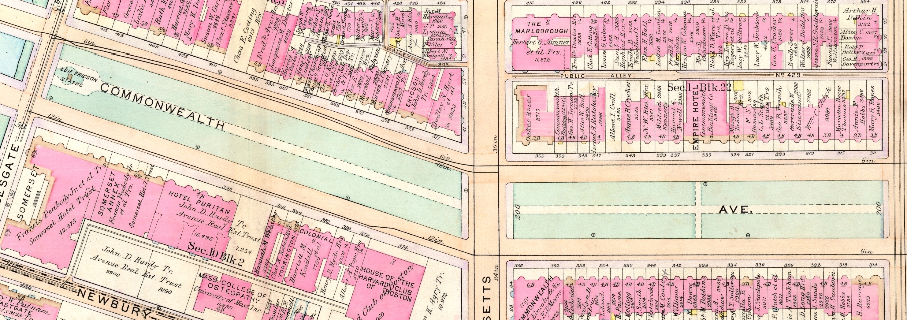
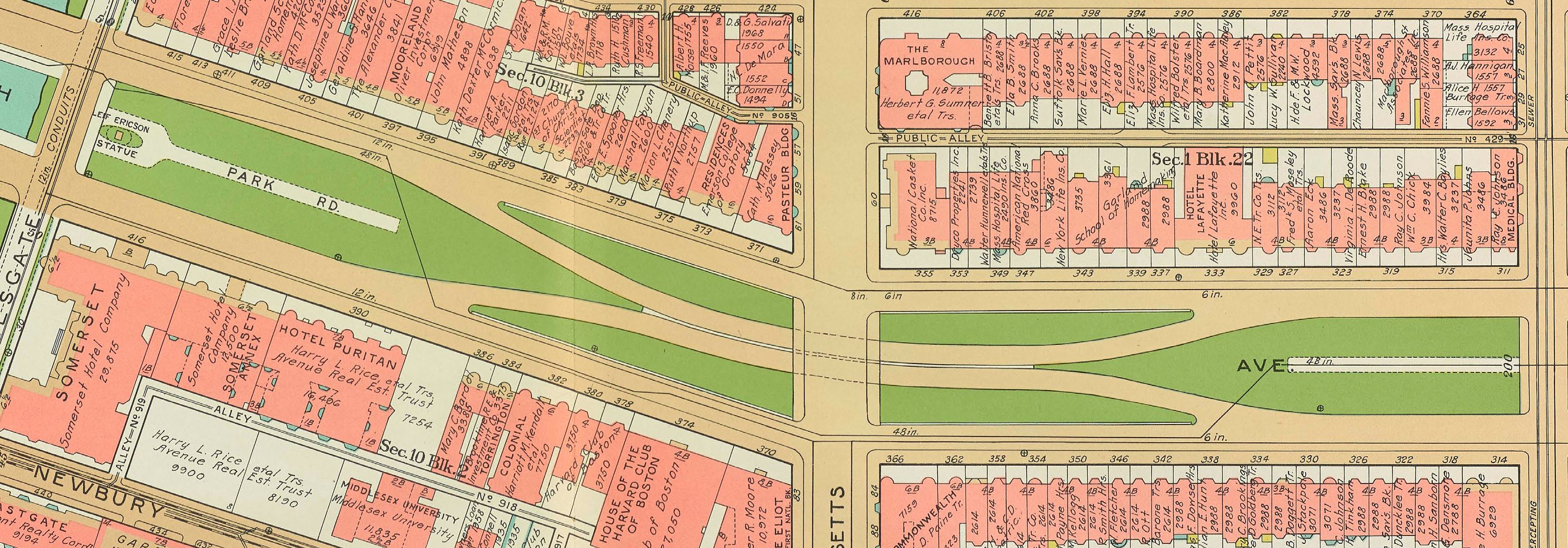
The land between Beacon and Commonwealth (north to south) and Massachusetts Avenue (formerly West Chester Park) and Charlesgate East (formerly Ipswich) (east to west) evolved from a single parcel owned by the Boston Water Power Company. Unlike the blocks further east in the residential portion of the Back Bay, it is not rectangular but rather has an irregular shape that accommodates angled the routes of Commonwealth and Charlesgate East.
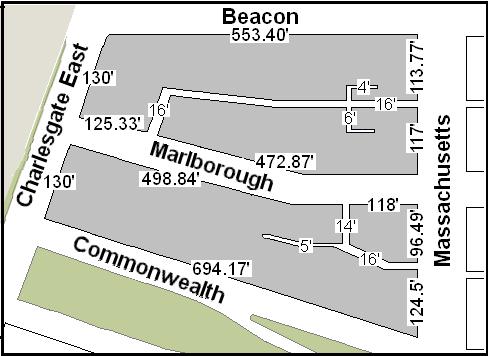 The lengths of the streets between Massachusetts Avenue and Charlesgate East are:
- South side of Beacon: 553.40 feet
- North side of Marlborough: 614.20 feet (including a sixteen foot wide passageway)
- South side of Marlborough: 630.84 feet (including a fourteen foot wide passageway)
- North side of Commonwealth: 694.17 feet
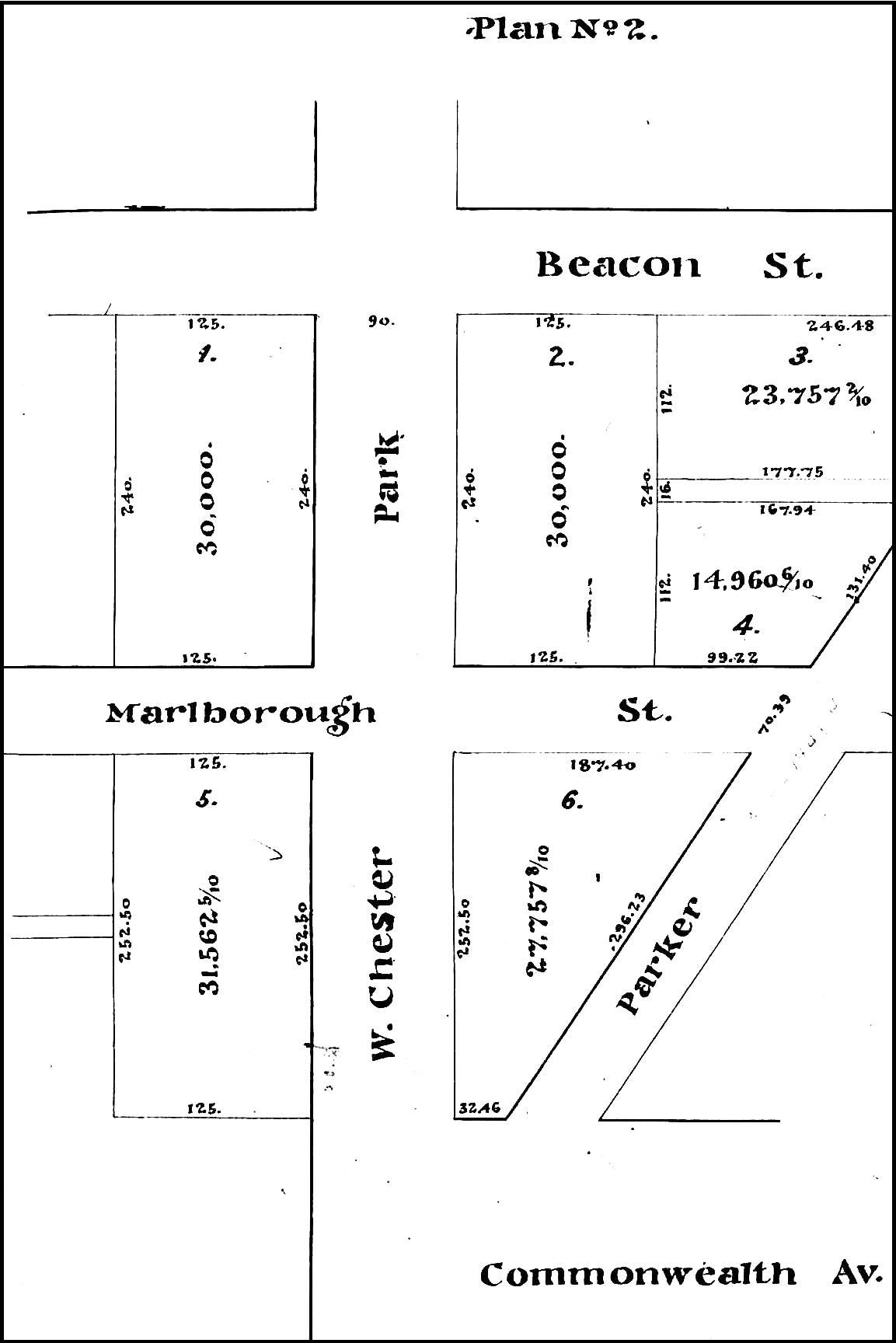
1872 to 1885: Original Land Sales and Laying Out of Commonwealth and Marlborough
The Boston Water Power Company sold all of its land west of Massachusetts Avenue between the south side of Beacon and the north side of Commonwealth in two transactions, one in 1872 and the second in 1880.
Plan showing lots purchased by the Beacon Street Lands Trust; Suffolk Co. Deed Registry, Book 1095, p. 1 (1Mar1872)
On March 1, 1872, it sold a parcel to the east to a real estate investment trust formed by Grenville T. W. Braman, Henry D. Hyde, and Frank W. Andrews, known as the Beacon Street Lands Trust. The trust also purchased several other parcels further east on the same day.
At the time of the sale, the land had not yet been filled and graded and neither Commonwealth nor Marlborough had been extended beyond Massachusetts Avenue (West Chester Park). It was assumed that both streets would extend west in a straight line. The parcel therefore was rectangular in shape, with a 125 foot frontage on Beacon, a 508.5 foot frontage on Massachusetts Avenue (including the width of where Marlborough was expected to run), and a 125 foot frontage on what was assumed to be the northern boundary of where Commonwealth would run.
On December 28, 1877, the Boston Water Power Company transferred to the City of Boston the land needed to extend Commonwealth further west to what would become Charlesgate East.
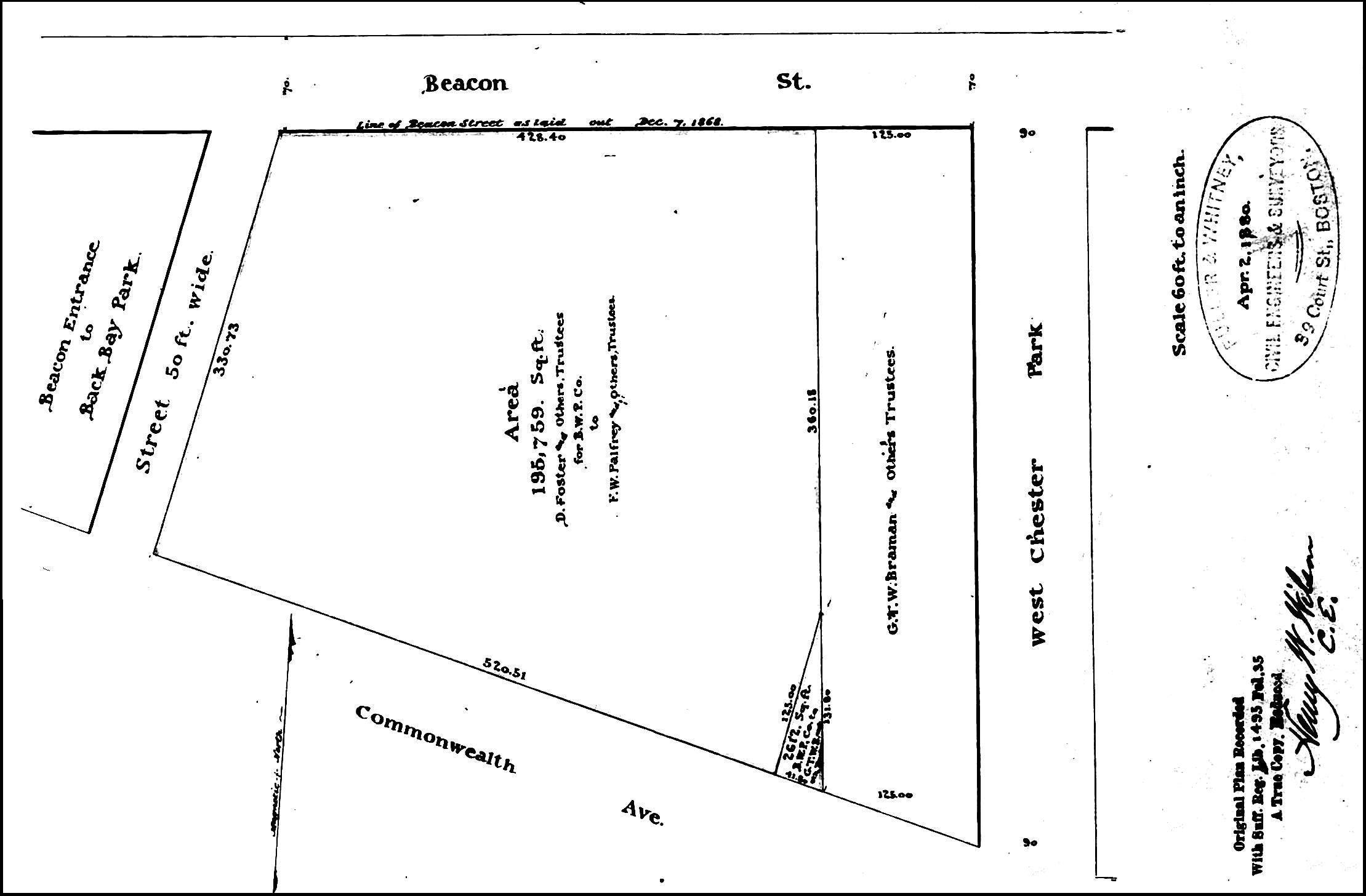
Plan showing triangular lot conveyed to the Beacon Street Lands Trust and parcel conveyed to the Commonwealth Avenue Lands Trust; Suffolk Co. Deed Registry, Book 1495, p. 35 (1Jun1880)
Commonwealth was laid out running northwest at an angle from Massachusetts Avenue (rather than continuing straight) and therefore included a triangular portion of the land the company previously had sold to the Beacon Street Lands Trust. The company continued to own the land to the west, and on June 1, 1880, it transferred the Beacon Street Lands Trust a triangular shaped lot of the same square footage as the land they had lost.
Also on June 1, 1880, the Boston Water Power Company transferred to the City of Boston the land needed for Charlesgate East between Commonwealth and Beacon, and the company sold the remainder of its land between Beacon and Commonwealth west of the land owned by the Beacon Street Lands Trust to a separate real estate investment trust formed by Francis W. Palfrey, Francis A. Osborn, and Grenville T. W. Braman, known as the Commonwealth Avenue Lands Trust.
The Boston Water Power Company’s lands were subject to a mortgage bond indenture, and in their deed to the Commonwealth Avenue Lands Trust, the company identified two parcels as “reserved,” each with a frontage of 150 feet on what was anticipated to be the location of Marlborough. It appears these parcels were reserved as security for the bondholders.
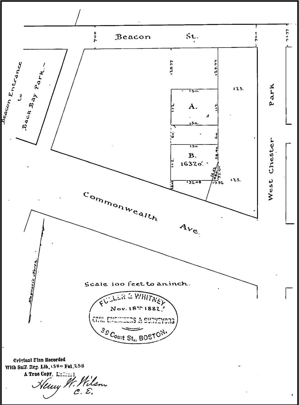
Plan showing “reserved” lots (marked “A” and “B”) conveyed to Henry M. Whitney; Suffolk Co. Deed Registry, Book 1580, p. 257 (24Nov1882)
On November 24, 1882, the trustees of the bond indenture foreclosed and sold the two parcels to Henry Melville Whitney. He was a shareholder in both the Commonwealth Avenue Lands Trust and the Beacon Street Lands Trust, and in March of 1879 he had replaced Frank W. Andrews as a trustee of the Beacon Street Lands Trust.
On December 15, 1882, the Beacon Street Lands Trust and the Commonwealth Avenue Lands Trust, “being desirous that that portion of Marlborough Street be laid out as a public street,” transferred to the City of Boston the land required to extend the street from Massachusetts Avenue to Charlesgate East. The extension was 50 feet wide, as compared with the 60 foot width of Marlborough further east.
On February 25, 1883, the Beacon Street Lands Trust sold all of its land to Henry Lee, H. Hollis Hunnewell, and Augustus Lowell.
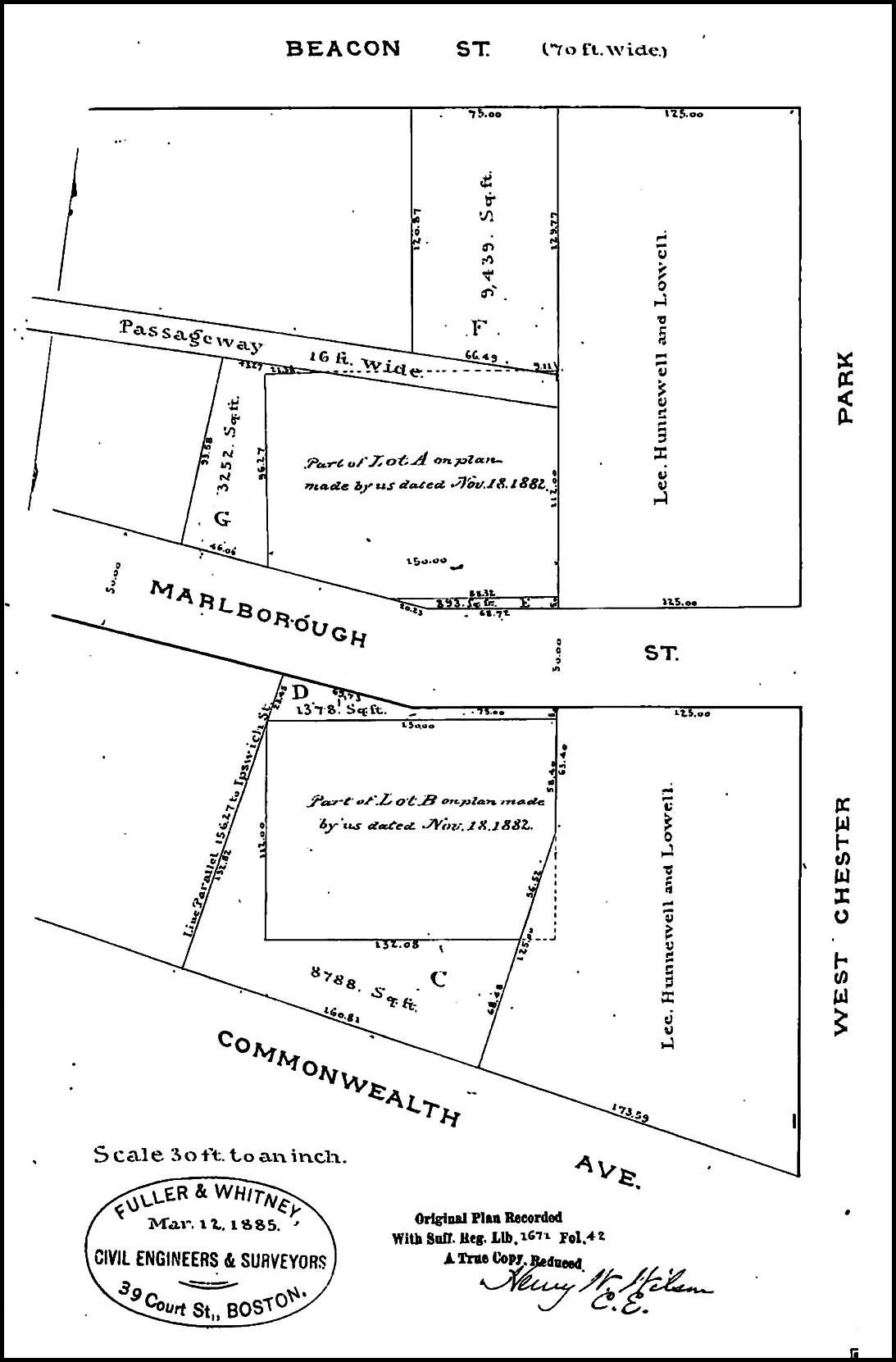
Plan showing lots conveyed to Henry M. Whitney to augment his lands; Suffolk Co. Deed Registry, Book 1671, p. 42 (20Mar1885)
Marlborough was laid out running straight for about 194 feet and then at an angle running northwest to Charlesgate East. As a result, both of the parcels acquired by Henry M. Whitney on November 24, 1882, were set back from the street. On March 20, 1885, the Commonwealth Avenue Lands Trust sold additional land to Henry Whitney so that his land would front on both sides of Marlborough and on Commonwealth.
1885 to mid-1888: Sale of Single and Multiple Lots, Creation of Alleys and Passageways, and First Construction of Houses
As of January 1, 1885, all of the land was held by three owners: Henry Lee and his partners owned the eastern portion, Henry M. Whitney owned the central portion, and the Commonwealth Avenue Lands Trust owned the western portion.
On June 10, 1885, the landowners entered into an agreement creating a sixteen foot wide passageway running west from Massachusetts Avenue between Beacon and Marlborough to a point about 452 feet west of Massachusetts Avenue and then turning south to connect with Marlborough, This passageway became Alley 908.
Starting in mid-1885, all three landowners began to sell parcels of their land. Henry Whitney was the first to divest his land, followed by the Commonwealth Avenue Land Trust. Henry Lee and his partners moved more slowly.
In June of 1885, Henry M. Whitney sold his land between the north side of Commonwealth and the south side Marlborough (379-391 Commonwealth and 430-440 Marlborough) to building contractor George Wheatland, Jr.
Also in June of 1885, he entered into an agreement with building contractors N. Henry Chadwick and Oscar L. Stillings under which they built houses on his land on the north side of Marlborough (431-445 Marlborough). He sold them the land at 437-445 Marlborough and they sold the houses to individual buyers after they were completed. He retained the land at 431-435 Marlborough and after Chadwick & Stillings completed the houses, he sold them to individual buyers.
In October of 1885, Henry Whitney sold his land between Beacon and the alley (503-507 Beacon and part of 509 Beacon) to Lewis S. Dabney, who sold it the next month to Louis Curtis.
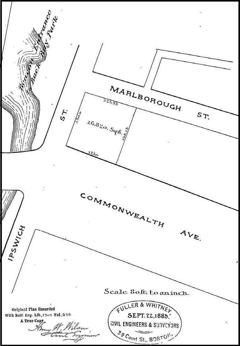
Plan showing lot conveyed to Walter Hunnewell; Suffolk Co. Deed Registry, Book 1707, p. 375 (21Dec1885)

Plan showing lot conveyed to Augustus Lowell (Lot “A”); Suffolk Co. Deed Registry, Book 1711, p. 34 (26Jan1886)
In December of 1885, the Commonwealth Avenue Lands Trust sold the lot at the western end of its property between Commonwealth and Marlborough (413-415 Commonwealth and 24 Charlesgate East) to Walter Hunnewell.
In January of 1886, the trust sold the western end of its property between Beacon and Marlborough (4-10 Charlesgate East and 459 Marlborough) to Augustus Lowell, and the remainder of its land between Commonwealth and Marlborough (393-409 Commonwealth) to individual purchasers.
Henry Lee and his partners subdivided their land between Beacon and Marlborough to provide for two pairs of passageways to provide access and drainage to the alley. North of the alley, they created a four foot wide passageway at the rear of 499 Beacon and 501 Beacon, connecting with a six foot passageway extending south behind 29 Massachusetts Avenue. South of the alley, they created a four foot wide passageway behind 427-429 Marlborough connecting with a six foot wide passageway extending north to the alley behind 31 Massachusetts Avenue. Unlike similar passageways elsewhere in the Back Bay (for example, at the rear of houses facing on the side streets), these passageways were not created as easements over the lots, but as separate open spaces “appurtenant to the granted premises” to which each property owner had access in common with the owners of the other the abutting properties.
Plan showing passageways connecting to Massachusetts Avenue and Marlborough; Suffolk Co. Deed Registry, Book 1717, p. 18 (15Mar1886)
On March 15, 1886, Henry Lee and his partners (as owners of the land at 424-428 Marlborough, 47-51 Massachusetts Avenue, and 371-377 Commonwealth) and George Wheatland, Jr. (as owner of the land at 430-440 Marlborough and 379-391 Commonwealth) entered into an agreement creating a sixteen foot passageway running west from Massachusetts Avenue to the western boundary of 428 Marlborough, connecting with a 14 foot wide passageway running north to Marlborough. The agreement also provided for a five foot wide passageway running west from the end of the sixteen foot passageway to the eastern boundary of 391 Commonwealth. The agreement stipulated that the owners of land at 424 Marlborough, 47-51 Massachusetts Avenue, and 371-377 Commonwealth would have the right to use the sixteen foot wide passageway and the fourteen foot wide passageway, but not the five foot wide passageway. Similarly, the owners of land at 379-391 Commonwealth and 430-440 Marlborough would have the right to use the 5 foot passageway and the fourteen foot passageway, but not the sixteen foot passageway. These passageways subsequently became Alley 905.
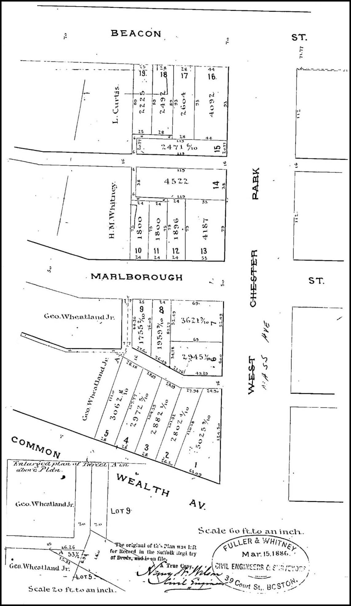
In April of 1886, Henry Lee and his partners sold the lot at 428 Marlborough to Albert and Ella (Frost) Morse, and in June of 1886, they sold the lots at 426 Marlborough and at 425-427-429 Marlborough to George Wheatland, Jr.
In September of 1886, the Commonwealth Avenue Lands Trust sold a lot with a 23 foot frontage at the eastern end of its land on the north side of Marlborough (447 Marlborough) to Francis Parker.
In January of 1887, the trust sold a five foot lot on the south side of Beacon at the east boundary of their land to Samuel S. Allen, who combined it with a 15 foot lot he had acquired from Louis Curtis and built 509 Beacon as his home. That same month, the trust sold the remainder of its land on the north side of Marlborough (449-457 Marlborough) to George Wheatland, Jr.
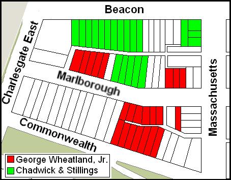
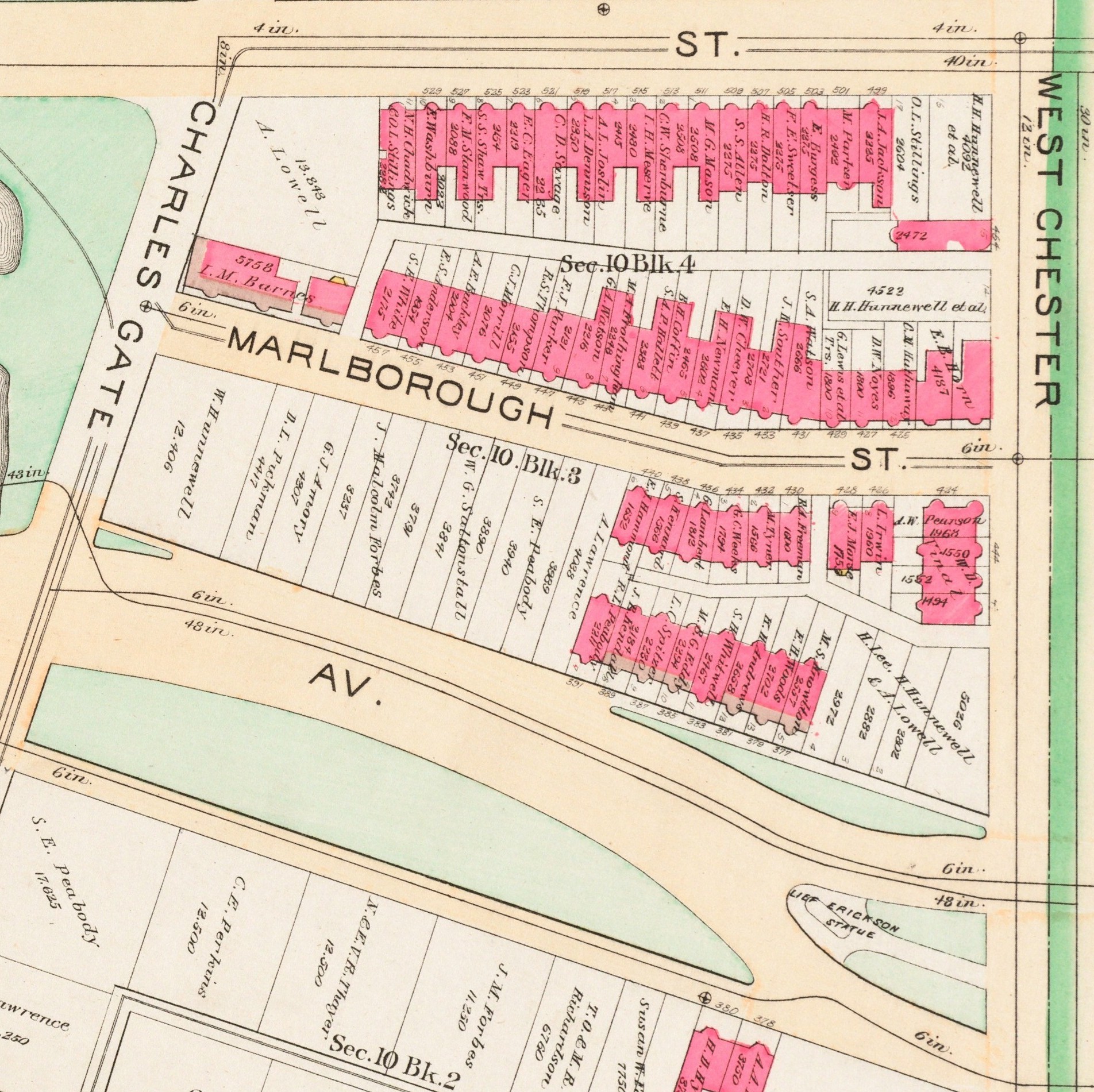
Land owned by George Wheatland, Jr., and Chadwick & Stillings
In March of 1887, the trust sold the rest of its land on Beacon (511-531 Beacon) to building contractors N. Henry Chadwick and Oscar L. Stillings.
In June of 1887, Henry Lee and his partners sold the land at 501 Beacon to Francis and Mary (Codman) Parker, and in April of 1888, they sold the land at 499-501 Beacon to builder and building contractor Silas W. Merrill.
By mid-1888, Henry M. Whitney and the Commonwealth Avenue Lands Trust had sold all of their holdings. Much of the land had been acquired by two building contractors, George Wheatland, Jr., and the partnership of N. Henry Chadwick and Oscar Stillings.
Mid-1888 to 1890: Land sales and Development Continue
By mid-1888, dwelling houses had been built on much Beacon and Marlborough, primarily on land developed by George Wheatland, Jr., and Chadwick & Stillings. On Commonwealth, the only homes built were those constructed by George Wheatland, Jr.
1888 Bromley map
Although the Commonwealth Avenue Lands Trust had sold its holdings on Charlesgate East and on Commonwealth, the property remained vacant. Henry Lee and his partners continued to own all of their vacant land on Commonwealth (371-377 Commonwealth) and on Massachusetts Avenue (491 Beacon, 27-29-31 Massachusetts Avenue, 421-423 Marlborough, 424 Marlborough, 47-49-51 Massachusetts Avenue).
Between 1888 and 1890, little development occurred on the land formerly owned by the Commonwealth Avenue Lands Trust. The only buildings constructed were at 10 Charlesgate East and 459 Marlborough, both for Thurlow and Isabel (Morris) Barnes.
1890 Bromley mao
Henry Lee and his partners sold the lot at 29 Massachusetts Avenue in December of 1888 to Brooks Adams, who built his home there; the lots at 424 Marlborough and 47-49-51 Massachusetts Avenue in February of 1889 to builder Warren D. Vinal, who constructed built four dwelling houses for speculative sale; the lot at 377 Commonwealth and two feet of the lot at 375 Commonwealth to Josiah B. Kendall, who conveyed it that same month to building contractor Albion Knowlton who built his home there; and the lots at 421-423 Marlborough in October of 1889 to jeweler and real estate developer Edwin Horn, who built a six unit apartment house at 421 Marlborough and a four unit apartment house at 423 Marlborough.
Henry Lee and his partners also sold the lot at 495-497 Beacon in August of 1888 to Oscar Stillings of Chadwick & Stillings. It remained undeveloped in 1890.
1890 to 1895: Development Continues
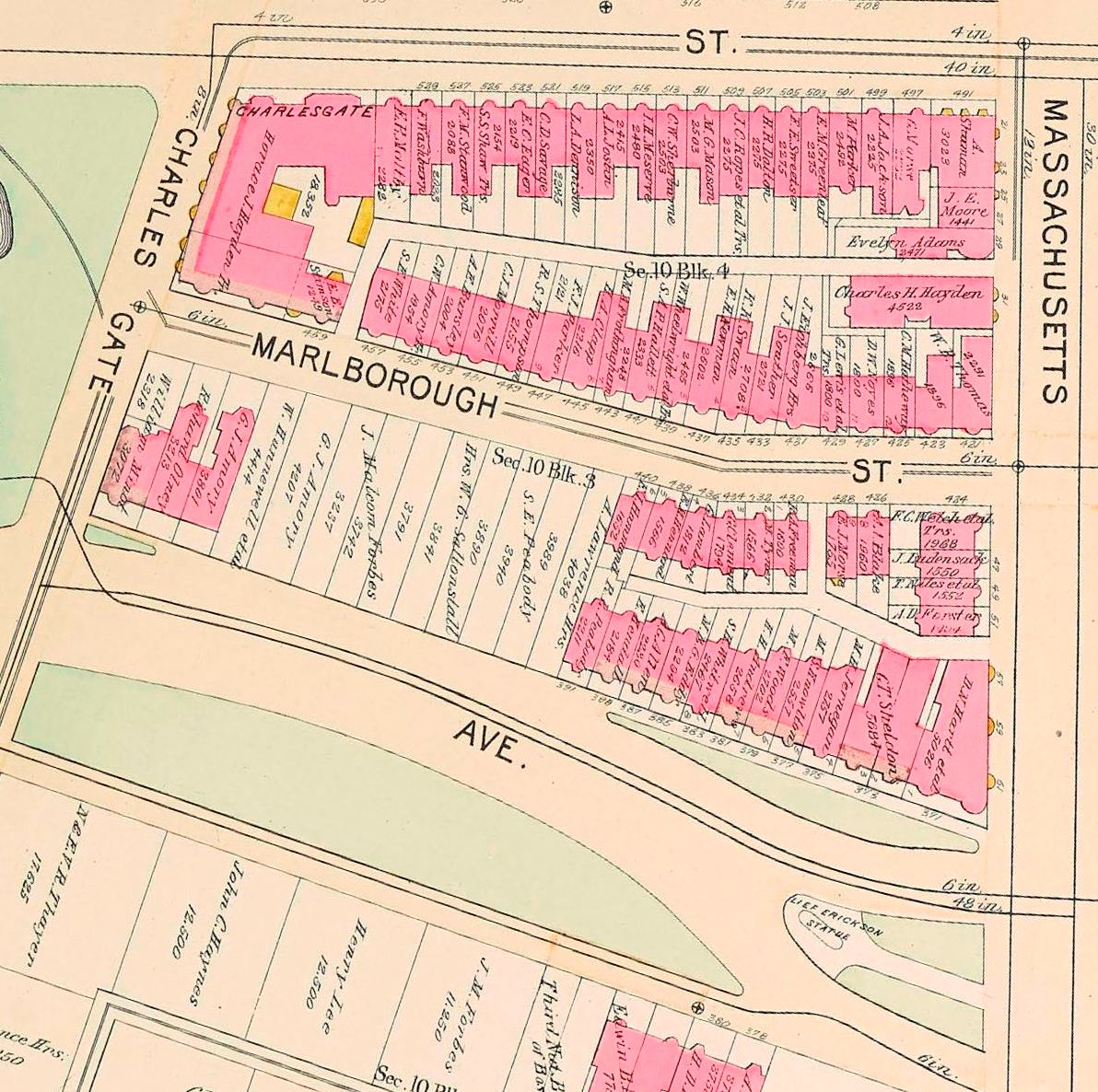
Between 1890 and 1895, all of the remaining vacant land on Beacon, Marlborough, and the east end of Commonwealth was developed. The lots on the north side of Commonwealth at 393-411 Commonwealth remained vacant.
1895 Bromley map
In April of 1890, Henry Lee and his partners sold the lots at 491 Beacon and 27-29 Massachusetts Avenue to real estate dealer Seth R. Baker, and in May of 1890, Oscar Stillings sold him the lot at 495-497 Beacon that he had purchased in August of 1888. Seth Baker subsequently had three multi-unit buildings built on the land.
In March of 1891, Henry Lee and his partners sold the lot at 31 Massachusetts Avenue to Edwin Horn, where he built a twelve unit apartment house. He previously had built apartment houses on the lots to the south, at 421 and 423 Marlborough.
Henry Lee and his partners sold their remaining land, at 371-375 Commonwealth, between December of 1890 and August of 1892. In 1892-1893, real estate developer Albert Geiger built The Chesterfield apartments at 371 Commonwealth, the Ericson Hotel Trust built The Ericson apartment building at 373 Commonwealth, and Holmes and Mary (Morrill Jernegan built their home at 375 Commonwealth.
The Charlesgate at the northeast corner of Beacon and Charlesgate East (4 Charlesgate East/535 Beacon) was built in 1891, 413-415 Commonwealth were built in 1890-1891, and 24 Charlesgate was built in 1891-1892.
The lots at 393-411 Commonwealth – all of which were exceptionally deep, extending from Commonwealth to Marlborough – remained vacant until the late 1890s.
The first house on this land was 409 Commonwealth, built in 1898 for attorney William Minot, III. Houses on the remainder of the lots, with the exception of 397 Commonwealth, were built between 1899 and 1902.
397 Commonwealth remained a vacant lot until 1924, when the Moorland Company built what became the Fraternities Club and then an apartment house.
Commonwealth Avenue Mall
1912 Bromley map
As originally laid out, Commonwealth Avenue between Massachusetts Avenue and Charlesgate East had a curved roadway intended to provide a transition from the formal central mall design of the preceding blocks to the parklands in the Back Bay fens. It included a triangular island at the eastern end on which the statue of Leif Ericson (Erikson) was located (dedicated in 1887), an irregularly shaped strip of green space on the north side in front of 371-387 Commonwealth, and an irregularly shaped island of green space on the south side, beginning at 378 Commonwealth and extending to Charlesgate East.
1922 Bromley map
In 1917-1918, the roadway was straightened and widened, the central mall design was extended to Charlesgate East, and the green space in front of 371-387 Commonwealth and 378-416 Commonwealth was eliminated. The Ericson statue was relocated to the Charlesgate East end of the block.
In his inaugural address on January 7, 1930, Mayor James Michael Curley announced plans for an underpass at the intersection of Commonwealth and Massachusetts Avenue, allowing traffic on Commonwealth to travel through a tunnel below Massachusetts Avenue and then return to street level.
1938 Bromley map
Disagreements about how the costs of construction and relocation of gas and electric utilities would be funded delayed the project until 1937. Construction began in mid-1937, and the project was dedicated by Mayor Maurice J. Tobin on January 27, 1938.
The on- and off ramps for the underpass required reconfiguration of the Mall between Hereford and Charlesgate East.
Building Restrictions in Original Land Deeds
Both of the original land deeds from the Boston Water Power Company to the Beacon Street Lands Trust on March 1, 1872, and to the Commonwealth Avenue Lands Trust on June 1, 1880 included requirements that buildings be built of brick, stone, or iron; that buildings be not less than three stories in height including the basement; and that buildings not be used for a livery stable or for any mechanical or manufacturing purpose.
Neither deed included any requirement that houses be set back a specified distance from Beacon, Marlborough, or Commonwealth. However, setback requirements were included in subsequent agreements and land transfer deeds.
Beacon. On February 1, 1887, the owners of the land on the south side of Beacon between Massachusetts Avenue and Charlesgate East (Henry Lee and his partners, Louis Curtis, and the Commonwealth Avenue Lands Trust) agreed to a ten foot setback on Beacon, with steps, porticos, bays and bows, and other usual projections allowed in the reserved space, subject to depth and dimensional limitations similar to those required by the Commonwealth of Massachusetts deeds conveying its lands (as expanded upon by the regulations of the Commissioners on Public Lands).
Marlborough. On February 20, 1883, the owners of the land on both sides of Marlborough (the Beacon Street Lands Trust and the Commonwealth Avenue Lands Trust) agreed that all buildings on Marlborough between Massachusetts Avenue and Charlesgate East would be set back five feet.
This requirement was modified on June 10, 1885, as part of the agreement creating what would become Alley 908. In that agreement, the landowners (Henry Lee and his partners, Henry M. Whitney, and the Commonwealth Avenue Lands Trust) agreed that buildings on the north side of Marlborough located between Massachusetts Avenue and 125 feet west thereof (421-429 Marlborough) were to be set back ten feet from Marlborough, and buildings located on lots between 125 feet and 323.66 feet west of Massachusetts Avenue (431-445 Marlborough) were to be set back by a line ten feet north of Marlborough on the east (at a point 125 feet west of Massachusetts Avenue) and 5 feet north of Marlborough on the west (at a point 323.33 feet west of Massachusetts Avenue). The agreement allowed steps, porticos, bays and bows, and other usual projections in the reserved space, subject to depth and dimensional limitations. The agreement did not impose a setback restriction on the land further west (447-459 Marlborough).
The five foot setback agreed to on February 20, 1883, remained in force for the south side of Marlborough and affected both houses that fronted on Marlborough and houses at the western end of the block that fronted on Commonwealth.
Commonwealth. On February 20, 1883, when the Beacon Street Lands Trust sold its land to Henry Lee and his partners, the deed included language requiring that buildings on Commonwealth be set back twenty feet, with doors, porticos, windows, and roof cornices allowed to project into the reserved space subject to depth and dimensional limitations. This affected buildings built at 371-377 Commonwealth. No setback requirement was included in land deeds for the rest of the block, but the buildings nevertheless reflected a uniform twenty foot setback.
