| Overview – 1855-1859 – 1860-1864 – 1865-1869 – 1870-1874 – 1875-1879 – 1880-1884 – 1885-1889 – 1890-1899 – 1900-1909 – 1910-2015 |
By 1910, construction of the original single-family residences in the Back Bay had been completed. The last single-family dwelling built on a previously vacant lot was at 530 Beacon, built in 1908. As of 1910, there remained thirteen vacant lots in the residential portion of the Back Bay.
The changes in the neighborhood emerging at the turn of the 20th Century accelerated over the subsequent decades. The popularity of large, in-town, single-family homes declined and those who wished to live in town opted increasingly for the growing number of apartment buildings. Economic pressures, the difficulty and expense of obtaining servants to maintain the large homes, the desire for newer and more modern accommodations, the popularity and accessibility of suburban life, and changes in tastes and fashion all contributed to this change.

520 Beacon (2015), one of several large apartment buildings built during the first quarter of the 20th Century.
After 1910, construction in the residential portion of the Back Bay focused on new multiple dwellings. Twelve of the remaining thirteen vacant lots were subsequently occupied by the Van Courtland Apartments at 520 Beacon built in 1912, the Harvard Club of Boston at 374 Commonwealth built in 1912, the Hotel Fensgate at 534 Beacon built in 1923, the Maryland Apartments at 512 Beacon built in 1925, the Moorland Apartments at 397 Commonwealth built in 1924, the Eliot Hotel at 370 Commonwealth built in 1925, an apartment building at 345 Commonwealth built in 1925, and a residential and commercial building at 388 Commonwealth built in 1983. The thirteenth vacant lot, at 428 Beacon. remained undeveloped in 2015 and is used for parking by the New England College of Optometry at 424 Beacon.
After World War I, an increasing number of former single-family dwellings were converted into apartments, lodging houses, medical and professional offices, dormitories, fraternity houses, schools, and other institutions.
During the Depression and World War II, this trend intensified, with an increasing number of single-family houses converted to multi-family dwellings (apartments and lodging houses). Some of these conversions involved extensive remodeling, including “modernizing” the façades of existing buildings (e.g., 113 Commonwealth in 1936, 140 Beacon in 1936, 120 Beacon in 1937, and 122 Beacon in 1959), and, in some cases, combining two or more existing buildings into single properties (e.g., 236-238 Beacon).
113 Commonwealth (2014), one of several buildings remodeled with modernized façades during the 1930s, 1940s, and 1950s
The conversion from residential to non-residential uses or temporary housing – offices, dormitories, fraternities, schools, and other institutions — also continued and accelerated.
These uses were not new to the Back Bay. From the 1880s, and possibly before, some residents had accepted lodgers, and it was quite common for physicians to maintain their offices in their homes and to rent offices to other physicians. In several cases, houses were designed specifically to combine a residence and medical offices: for example, 226 Marlborough built in 1882 and 16 Exeter (196 Marlborough) built in 1886, both designed by architect William Whitney Lewis.
Private schools also were a feature of early Back Bay life. The earliest example appears to be at 68 Marlborough, where Miss M. Louise Putnam operated a school from 1872, and there were other examples in the late 19th Century, notably the Shaw School at 6 Marlborough from 1882, Edmund Hamilton Sears, Jr.’s, school for young ladies at 140 Marlborough from 1886, Miss Chamberlayne’s school for girls at 64 Commonwealth from 1893, and the Woodward School at 5 Marlborough from 1895. The number of schools increased in the early 1900s, among them Noble and Greenough School at 100 Beacon from 1901 and the May School at 339 Marlborough from 1903. And fraternities began purchasing property in the early 1900s, when Sigma Chi purchased 311 Beacon, followed by the MIT Chapter of Delta Upsilon at 526 Beacon in 1916.
After World War I, however, the prevalence and scale of these uses came to dominate the neighborhood. Scores of homes were subdivided into apartments or converted into lodging houses. Numerous houses and several large apartment buildings were converted to medical offices, among them the Hotel Tuileries at 270 Commonwealth in 1921, 311 Commonwealth in 1927, and The Graffam at 330 Dartmouth in the 1930s.
In the 1930s, encouraged by depressed property prices, schools and colleges began to acquire buildings in the Back Bay for use as classrooms and dormitories, and over the next three decades they amassed large holdings in the neighborhood. Among the educational institutions with significant amounts of property in the Back Bay were Boston University, Chamberlayne School and Chamberlayne Junior College, Chandler School for Women, Emerson College, Fisher College, Garland Junior College, Katharine Gibbs School, and Simmons College.

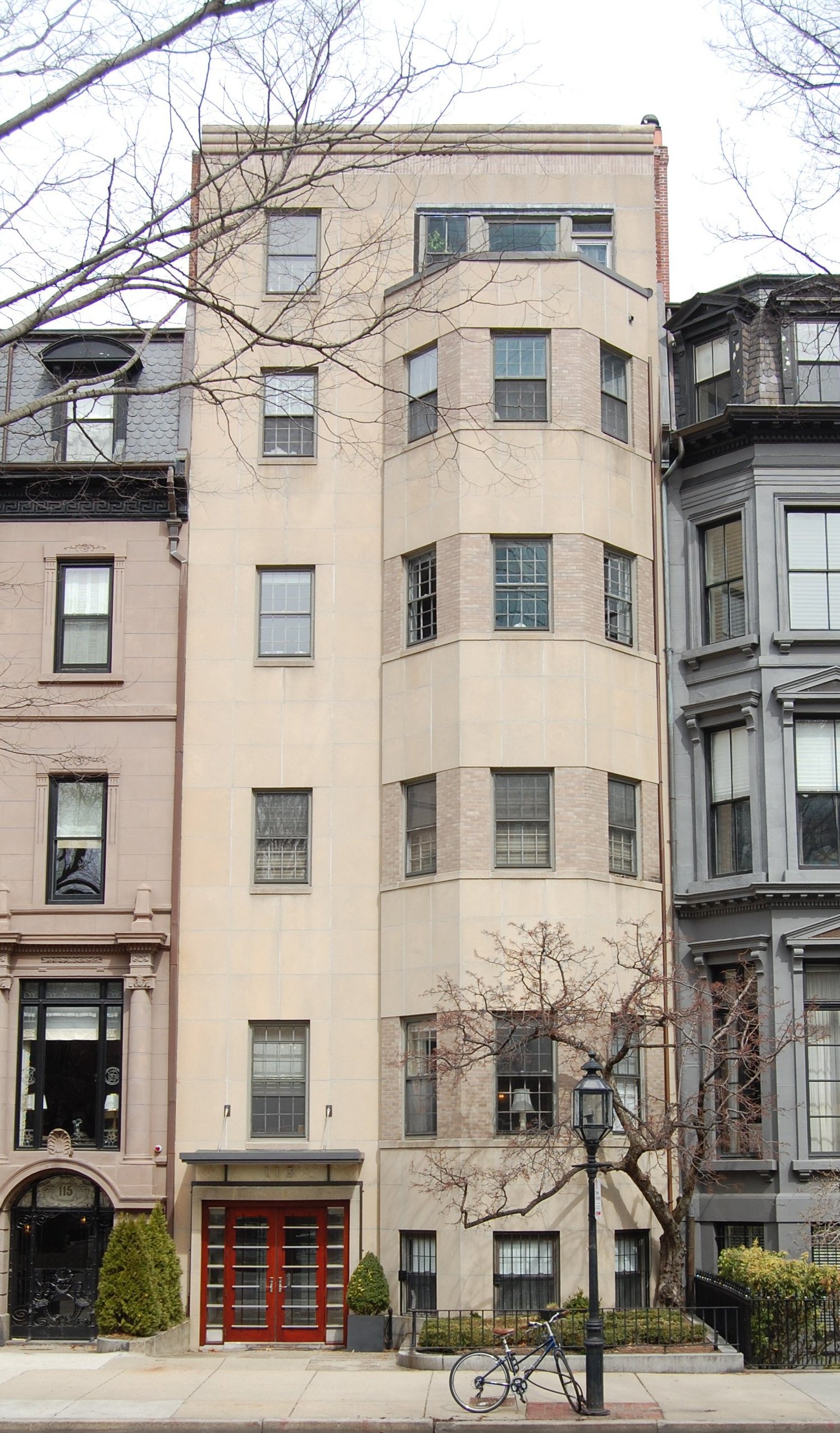
330 Beacon (2013), built in 1959, an example of the high rise future for the Back Bay envisioned by some planners and developers
In addition to acquiring and converting former single-family homes, schools also acquired several of the major apartment buildings in the neighborhood and converted them into dormitories. For example, in 1947 Boston University acquired The Charlesgate at 4-10 Charlesgate and in 1961 the Chandler School for Women acquired the Hotel Fensgate at 534 Beacon.
In the 1950s and 1960s, the focus of development was on replacing the original (and, in some cases, replacement) buildings with high-rise apartment buildings, which some believed were the only thing that would attract residents to the neighborhood. Two such buildings were built on the north side of Beacon, at 330 Beacon in 1959 and 180 Beacon in 1964. Two more were proposed for the northwest and northeast corners of Beacon and Dartmouth, and another at the corner of Clarendon and Commonwealth.
In July of 1967, the Back Bay Development Plan was prepared for the Boston Redevelopment Authority and the Back Bay Planning and Development Corporation by the firm of Adams, Howard and Oppermann. It recommended a comprehensive plan for renewal of the Back Bay that included high-rise buildings on almost every corner on the north side of Beacon facing the Esplanade, on the west side of Arlington facing the Public Garden, and on the east side of Charlesgate East facing Charlesgate Park. The plan included recommended zoning changes to facilitate construction of the new high-rise buildings.
Below is color-enhanced detail from the map which appeared in this study showing “Potentials for Ultimate Development” of the residential portion of the Back Bay. In addition to the two existing high-rise buildings at 180 Beacon and 330 Beacon, it shows 24 “proposed sites for high rise towers” and five more “sites approved for high rise towers by prior city ordinance” (including the locations of the Ames-Webster house at 306 Dartmouth and the Hotel Vendôme at 160 Commonwealth).
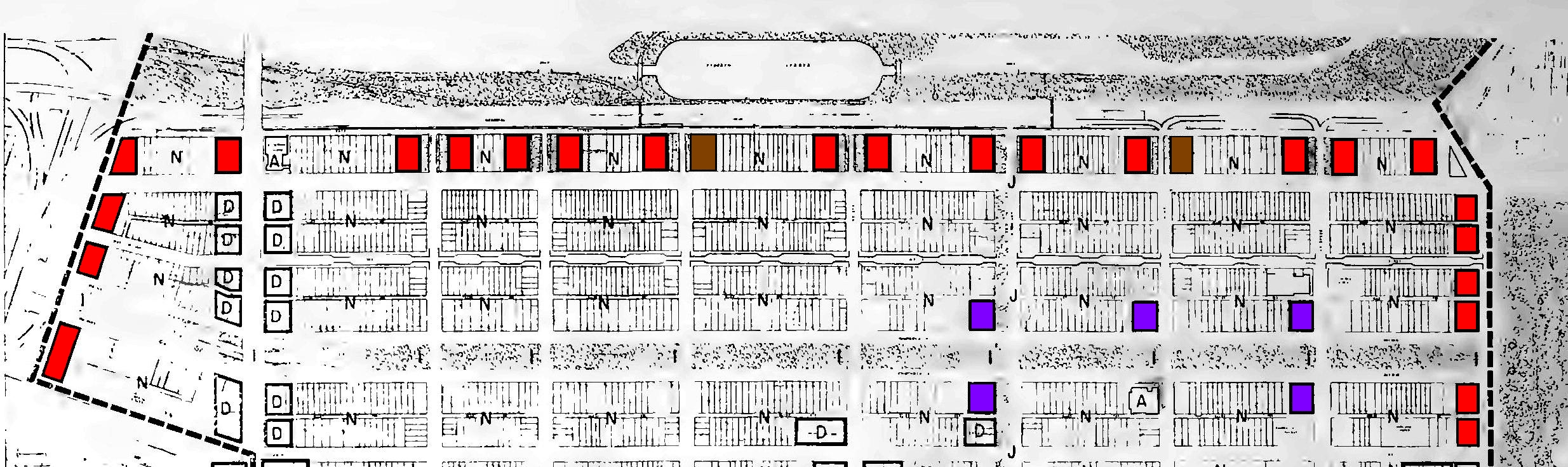
Color-enhanced detail from map showing “Potentials for Ultimate Development” from the Back Bay Development Plan (July 1967). Red = “proposed sites for high rise towers;” purple = “sites approved for high rise towers by prior city ordinance;” brown = “existing high rise development.” Areas marked “D” are “proposed sites for new construction or major renovation,” areas marked “A” are “institutional buildings expected to remain;” and areas marked “N” are “primarily for conservation/rehabilitation.”
By the 1960s, the Back Bay had begun to experience another trend, however, that ultimately overcame the efforts to transmogrify the neighborhood such as those proposed in the Back Bay Development Plan. New residents – often young families — were buying the historic buildings and renovating them, usually into multi-family dwellings where they lived and rented apartments to others. These residents saw a different future for the neighborhood, one that respected the historic buildings and made the Back Bay a place where families would again want to live.
These residents led strong and vocal opposition to destruction of the Back Bay’s historic buildings, and largely through their efforts, in 1966, the Massachusetts legislature established the Back Bay Architectural District and created the Back Bay Architectural Commission to ensure preservation of the historic neighborhood.
The early work of the Commission was aided by increasing public awareness of the value and beauty of the Back Bay’s historic architecture. This awareness was bolstered by the publication of Bainbridge Bunting’s Houses of Boston’s Back Bay, which explored the neighborhood’s architecture in expert detail, and by a 1969 exhibit at the Museum of Fine Arts: ”Back Bay Boston: The City as a Work of Art.” The book published in conjunction with that exhibit (and with the same name) included perceptive essays by Louis Mumford and Walter Muir Whitehill.
Preservation also was aided by an innovation in property ownership: condominiums. This new form of ownership allowed the large former single-family dwellings in the Back Bay to be subdivided into more usable spaces that could be owned by the people who lived there – an alternative to converting them into apartments, lodging houses, or dormitories that gave families an incentive to move to the neighborhood and invest in its preservation and improvement. The first conversion of an existing residential building into condominiums in Boston was at 20 Gloucester in November of 1969.
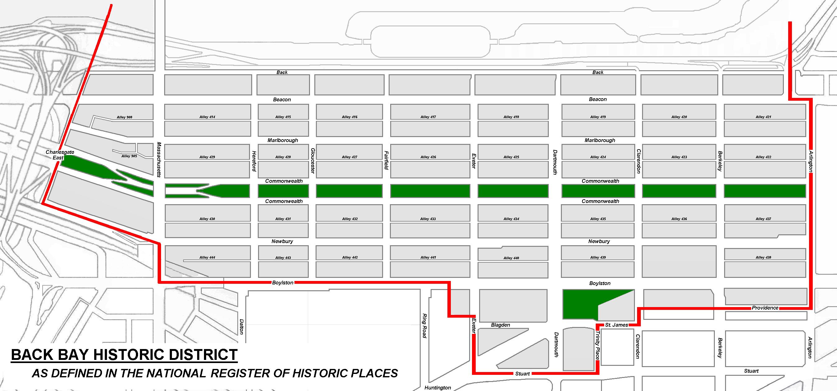
Boundaries of the Back Bay Historic District included in the National Register of Historic Places
In 1973, the neighborhood was added to the National Register of Historic Places, providing additional recognition of the historic and architectural importance of the neighborhood.
The original state legislation establishing the Back Bay Architectural Commission limited the area of its jurisdiction to the residential portion of the neighborhood, with the southern boundary being the north side of the alleys between Commonwealth and Newbury. The legislation referred to this area as the “Back Bay Residential District.” The boundaries of the neighborhood designated for inclusion on the National Register of Historic Places included not only this residential district but also the commercial district to Boylston Street and Copley Square (which includes three National Historic Landmarks: Old South Church and Trinity Church, both designated as landmarks in 1970, and the McKim building of the Boston Public Library, designated a landmark in 1986).
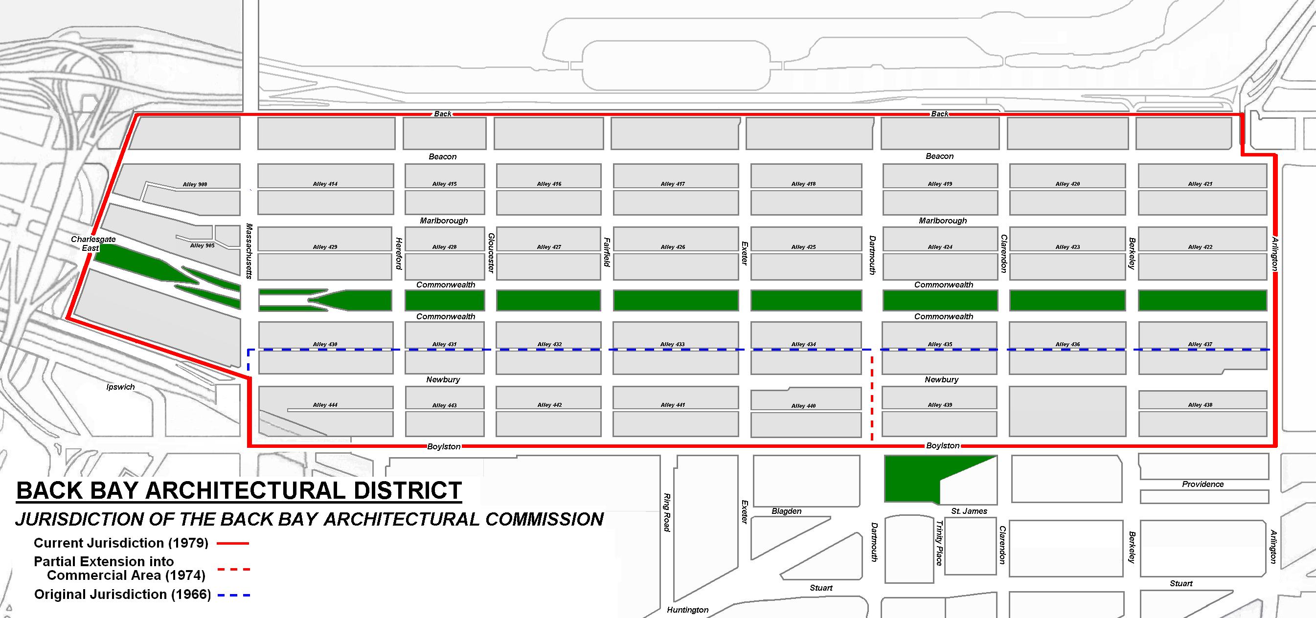
Boundaries of the Back Bay Architectural District, subject to the jurisdiction of the Back Bay Architectural Commission
In 1974, the Massachusetts legislature amended the state legislation to extend the district further south, to the north side of Boylston between Dartmouth and Massachusetts Avenue, thereby encompassing much of the commercial district. At the same time, it renamed the district to be the “Back Bay Architectural District.” In 1979, the legislature again amended the law so that the district would also include the rest of the commercial district on Newbury and the north side of Boylston between Arlington and Dartmouth. The legislation subsequently was amended on several occasions; as of 2018, the boundaries remained as established in 1979.
Click here for the text of the legislation creating the Back Bay Architectural District and Back Bay Architectural Commission.
The residents continued their efforts to preserve and improve the Back Bay, with much of their effort coordinated through the Neighborhood Association of the Back Bay (NABB). They focused on a wide range of issues, among them rejuvenating the Commonwealth Avenue Mall, fighting rats and trash, creating the Clarendon Street Playground (where the high-rise building previously had been planned), working with the city to address public safety issues, advocating zoning changes to limit the height and bulk of buildings and to require that non-residential uses (such as schools) be permitted only after public review at the Board of Appeal, and encouraging restaurants and businesses in nearby commercial areas that were compatible with the neighborhood’s needs. These efforts are summarized in 1955-2005: NABB’s First Fifty Years.
One of the residents’ priorities was reversing the proliferation of schools and dormitories in the residential area. That effort was aided in the mid-1970s when Chamberlayne School went bankrupt and its significant property holdings were sold and, in most cases, converted back to residential use. Also in 1970s, Garland Junior College faced financial difficulties and merged with Simmons College, which retained some of Garland’s 22 properties and sold the rest, again returning them to residential use.
During the subsequent decades, the trend towards returning Back Bay buildings to residential use continued, and in the early 2000 was significantly aided when both Simmons College and Emerson College opted to sell their Back Bay properties, Simmons to expand its Fenway campus and Emerson to establish a campus in Boston’s Theater District, resulting in significant improvements in that neighborhood.

2 Commonwealth (2013), built in 1981 on lots where five original houses had been demolished in 1963.
With zoning and historic preservation protections, the residential portion of the Back Bay has remained relatively intact since the 1980s. One additional tall building was permitted in 1981, the Carlton House condominiums at 2 Commonwealth at the southwest corner of Arlington. It was built on five vacant lots at 2-4-6-8-10 Commonwealth; the original houses had been demolished in 1963 for an earlier high-rise apartment building that was never built.
There were 1,156 buildings constructed on the originally vacant lots in the residential portion of the Back Bay, as defined for purposes of this website. As of 2015, 99 of these had been demolished. The last original buildings that were demolished were 451–453–455–457 Marlborough, razed in 1967 to make way for a one-story school building built by Garland Junior College and which, itself, was demolished in 2013 to be replaced by a new multiple dwelling.
By the late 20th and early 21st Centuries, the decline of the post World War I period had been reversed and the Back Bay was once again a highly desirable residential neighborhood. This improvement, combined with increased popularity of downtown (as opposed to suburban) living, spurred higher and higher prices in the neighborhood. Larger condominium units were developed, and several houses were converted back from apartments into single-family dwellings. The first new single-family dwelling built since 1908 was constructed on a vacant lot at 161 Commonwealth in 2011, where the previous house had been demolished in the early 1940s.
Below are two maps which indicate when buildings were constructed within the residential portion of the Back Bay. as defined for purposes of this website, plus buildings on the north side of Newbury. The dates used are based on original permit applications or similar documentation, when available. When no such documentation is available, the dates provided in Bainbridge Bunting’s Houses of Boston’s Back Bay are used.
The first map shows when a building was first constructed on a specific lot. If an original building was replaced or rebuilt, the date of original building (not the replacement) is shown. If a replacement building occupied both a vacant lot and the site of a previous building (e.g., 314 Commonwealth at the southwest corner of Hereford), the vacant lot is shown with the date of the replacement building and the previously occupied lot is shown with the date when the original house was built. This is the same format as the maps included in the sections on the earlier periods of the development of the Back Bay.
The second map shows when a building existing in 2015 was constructed. If an earlier building has been replaced, the year of construction of the newer building existing in 2015 is shown. Buildings which have been significantly remodeled (for example, with new façades or floor systems) are given their original date of construction, not the later date of remodeling. Additions at 287 Dartmouth and 00 Marlborough, which have their own addresses, are shown with the date of those additions. In two cases, buildings have been demolished but not replaced: at 260 Clarendon, location of the Clarendon Street Playground, and at 278 Dartmouth, location of a public parking lot. In these cases, the year shown reflects the year when the current use was established.
Following the maps is a list of the 56 buildings constructed between 1910 and 2015 in the residential portion of the Back Bay.

Original construction through 2015
Original Construction in the Back Bay as of 2015
Click here for a link to maps showing the progress of construction from 1855 through 2015, in slideshow format.

Buildings Existing in 2015, When Built
Back Bay Houses Existing as of 2015
Click here for a link to compare the maps showing when buildings were first constructed on the originally vacant lots and when the buildings in existence in 2015 were built, in slideshow format.
Below is a list of the 56 buildings constructed between 1910 and 2015 in the residential portion of the Back Bay. Buildings indicated as demolished were replaced by 2015; buildings indicated as replacements were built on lots where earlier structures previously were located; buildings indicated as partial replacements were built on a combination of vacant lots and lots where earlier structures had been located.
1923 301 Berkeley (Replacement)
