The development of the residential portion of the Back Bay achieved a high degree of architectural harmony largely as a result of detailed restrictions contained in the original deeds.
The Back Bay land was sold at a time before comprehensive municipal planning or zoning laws. The owners of the unfilled tidal land – the Commonwealth of Massachusetts, Boston and Roxbury Mill Corporation, and Boston Water Power Company – wanted to ensure that the neighborhood would attract purchasers who would pay a premium price. That meant ensuring that, as the land was developed, the houses were built to a high standard with a consistent height and relationship to the street, and that disruptive non-residential uses were not permitted. Absent zoning laws, these objectives were achieved by a series of deed restrictions that were binding on the purchasers and their successors, and that could be enforced by nearby land owners whose property might be affected by a violation.
All of the deed restrictions included in the original deeds later were incorporated, with some changes, into the provisions of the Boston Zoning Code.
The specific deed restrictions varied by the entity conveying the land, and also evolved over time. They usually restricted the type of buildings that could be built to dwelling houses and their appurtenant structures, and limited the type of material that could be used to brick, stone, or other non-combustible material. They also specified the number of feet the houses were to be set back from the arterial (east-west) streets, and required a minimum height (limiting the maximum height was not a concern in this pre-elevator era). The deeds also sometimes included specifics requirements that party walls be centered on the property lines with the costs be shared equally among the owners (frequently, however, these requirements were imposed through subsequent deeds or individual party wall agreements between owners; click here for more details on party wall agreements and stipulations).
The deeds from the Commonwealth served as a model for the deeds issued by the Boston and Roxbury Mill Corporation and Boston Water Power Company, which included similar language. Most of the deeds required the restrictions to be observed in perpetuity; however, those from the Boston and Roxbury Mill Corporation contained a “sunset” provision ending the restrictions after several decades.
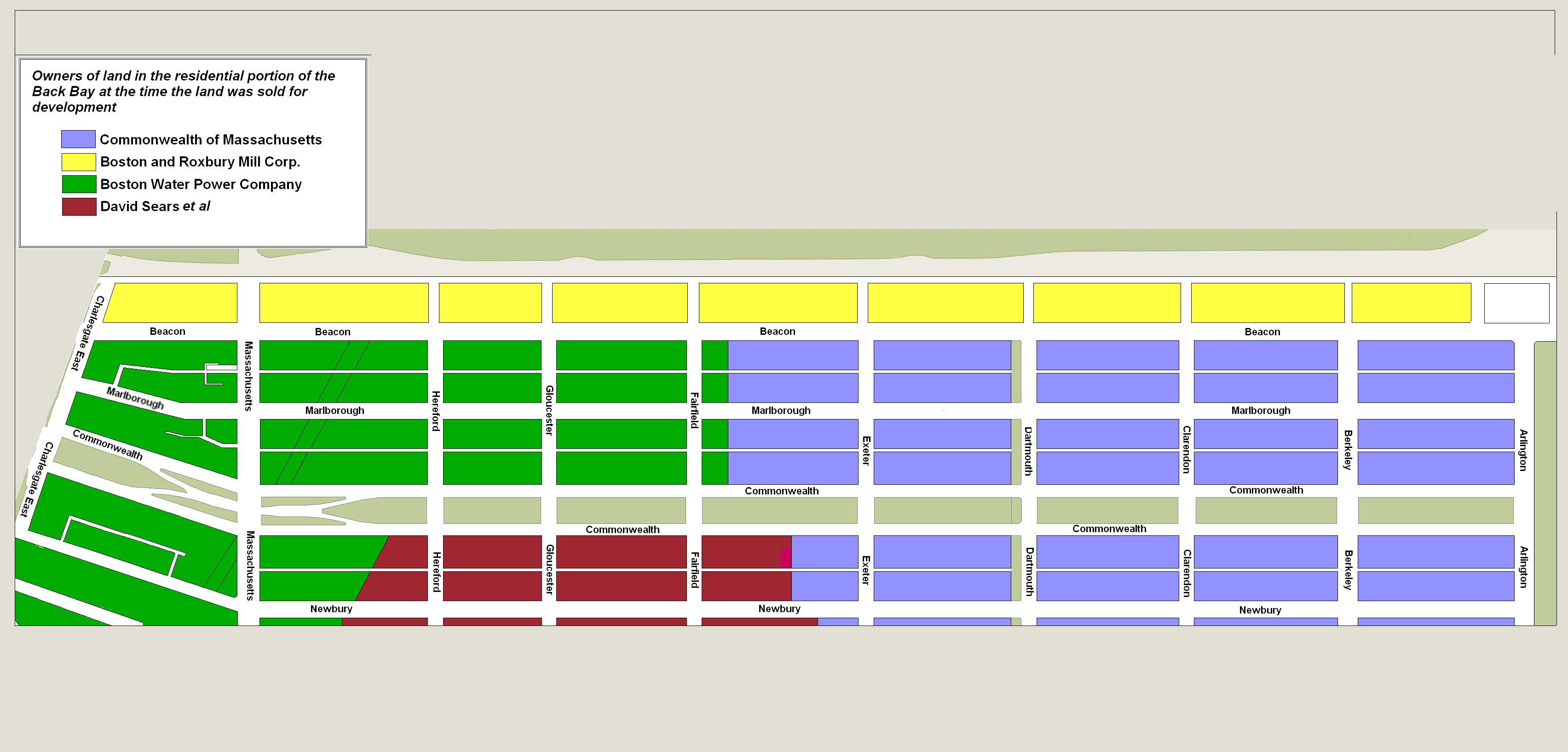
Approximate location of lands owned by the Commonwealth of Massachusetts, the Boston and Roxbury Mill Corporation, the Boston Water Power Company, and the David Sears family, drawn on the block plan for the residential portion of the neighborhood as of 2015.
The deeds for lands owned by the David Sears family did not include building restrictions. These lands were located on the south side of Commonwealth from a line mid-block between Exeter and Fairfield west to Massachusetts Avenue. After they were sold, the purchasers adopted agreements to require building restrictions similar to those in the deeds from the Commonwealth. The agreements for the blocks between Exeter and Hereford included both the south side of Commonwealth and the north side of Newbury. The December 7, 1878, agreement for the block between Hereford and Massachusetts Avenue, however, only included Commonwealth and not the north side of Newbury, which was planned for stables (by contrast, the land deeds for the for the south side of Newbury between Hereford and Massachusetts Avenue, also planned for stables, included a ten foot setback requirement).
The Commonwealth’s lands were administered by the Commissioners on Boston Harbor and the Back Bay (which became the Commissioners on the Back Bay in 1855, the Commissioners on Public Lands in 1861, and the Harbor and Land Commission in 1879).
The original Commonwealth deed restrictions specified (1) “That any building erected on the premises shall be at least three stories high, for the main part thereof, and shall not, in any event, be used for a stable, or for any mechanical, [mercantile, if the building is on Commonwealth Avenue] or manufacturing purposes; (2) that the front wall thereof, on [avenue or street], shall be set back [twenty, twenty-two, or twenty-five] feet from said [avenue or street], provided that steps, windows, porticos, and other usual projections appurtenant thereto, are to be allowed in said reserved space of [twenty or twenty-two] feet]; (3) That no cellar or lower floor of any building shall be placed more than four feet below the level of the mill-dam, as fixed by the top surface of the hammered stone at the south-easterly corner of the emptying sluices; (4) That a passage-way sixteen feet wide, is to be laid out in the rear of the premises, the same to be filled in by the Commonwealth, and to be kept open and maintained by the abuttors (sic) in common. And said Commonwealth reserves the right to enter upon the premises, by its agents, and, at the expense of the party at fault, to remove or alter, in conformity with the above stipulations, any building, or portion thereof, which may be erected on the premises by the said grantees, or their representatives or assigns, in a manner or to a use contrary to the above stipulations.’”
Setback Requirements
The Commonwealth’s setback requirements applied to the streets running east-west: twenty feet on Commonwealth Avenue; twenty-two feet on the south side of Beacon, both sides of Marlborough and Newbury, and the north side of Boylston, and twenty-five feet on the south side of Boylston.
The Boston Water Power Company incorporated the same setback requirements for the east-west streets in most of its land deeds. Deeds for land west of where Parker Street had been located (the western portions of Commonwealth, Marlborough, and the south side of Beacon) and for land west of Massachusetts Avenue did not include setback requirements. However, they were incorporated in subsequent deeds or in agreements between land owners.
Setback requirements for the north side of Beacon were included in the Boston and Roxbury Corporation’s deeds, and were different from the 22 foot setback established by the Commonwealth and the Boston Water Power Company for the south side of Beacon. The earliest deeds established a 19 foot setback for land between Otter Street (David G. Mugar Way) and a line fifty feet west of Berkeley (where 100-134 Beacon were built); the later deeds (starting on March 31, 1859) established a setback requirement of twenty feet for land west of where 134 Beacon would be built.
There were no setback requirements for the streets running north-south, presumably on the assumption that all corner houses would be built fronting the east-west streets. When several houses were built facing a street running north-south, they often were built by a single owner or building contractor who maintained a consistent setback (for example, 263–265–267 Clarendon/92 Marlborough and 9–11–13–15 Gloucester). In cases when more than one owner was involved, however, they sometimes included language in the land transfer deeds, or entered into separate agreements, requiring setbacks, limiting the depth of the houses, and establishing easements at the rear of the lots to ensure that all houses could have access to the alley or main street. Examples are the houses at 230–232–234-236 Clarendon and 277–279–281–283 Dartmouth.
In January of 1863, the Commissioners revised the deed restriction with respect to the setback requirement to specify “that the front wall thereof on [street or avenue] shall be set back twenty [or twenty-two] feet from said [street or avenue] but steps, windows, porticos and other usual projections appurtenant to said front wall are to be allowed in this reserved space of twenty [or twenty-two] feet, subject to the following limitations, namely, first, that no projection of any kind (other than door-steps and balustrades connected therewith, and also cornices at the roof of the building,) will be allowed to extend more than five feet from said front wall into said space; and, second, that no projection in the nature of a bay-window, circular front or octagon front, with the foundation wall sustaining the same, (such foundation wall being a projection of the front wall,) will be allowed, unless any horizontal section of such projection would fall within the external lines of a trapezoid, whose base upon the rear line of the aforesaid space does not exceed seven-tenths of the whole front of the building, nor exceed eighteen feet in any case, and whose side lines make an angle of forty-five degrees with the base; and each house in a block shall be considered a separate building within the meaning of this limitation.”
In their annual report for 1863, the Commissioners explained that this revision was “to avoid confusion” regarding the meaning of the term “usual projections.” The report also noted that that “the indenture between the Commonwealth and the Water-Power Company of December 27, 1856, contained a clause relative to ‘usual projections’ which the company, by the act of its president, in writing, now agree to accept according to the new form of conveyance adopted by the Commonwealth.”
In March of 1869, testifying in Linzee v. Mixer (see below), Commissioner Franklin Haven commented on the circumstances that led to adopting this more specific language: “Soon after the Commonwealth had given deeds of land on the Back Bay…it became a question of what projections could be built out into the reserved space. Some persons built octagonal projections; and, to avoid future difficulty, the commissioners established the new form of deed which has been used since January 28, 1863… The commissioners always considered that this was a fair construction of the restrictions and limitations of the former deed, and on October 26, 1865, voted accordingly.”
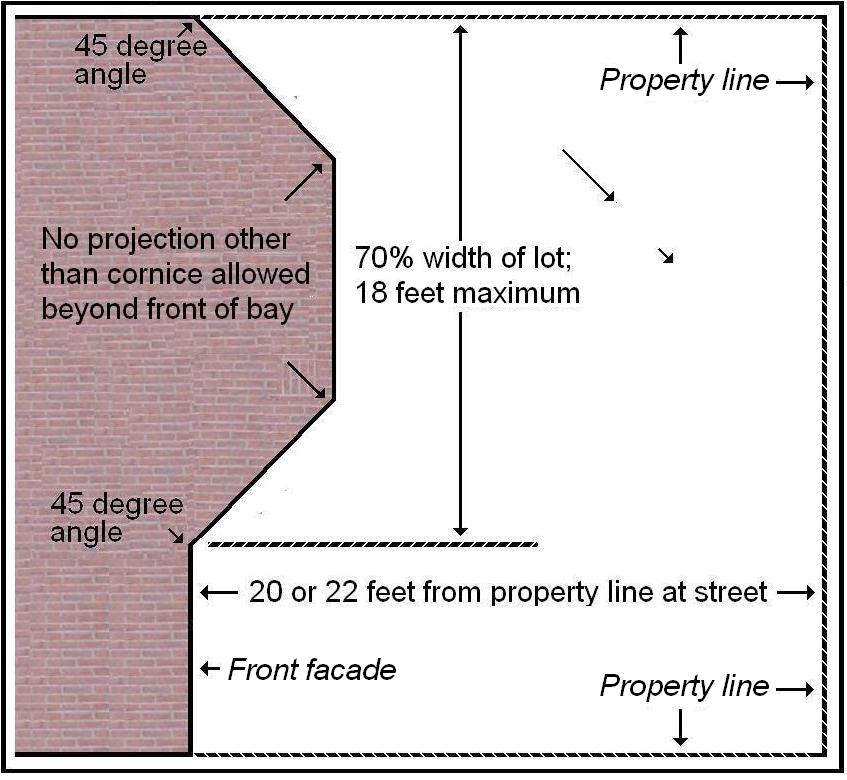
Illustration of the setback restrictions adopted in 1863
The drawing to the left illustrates graphically the setback requirement of the 1863 (and later) deed restrictions.
The setback requirements in the deeds relating to Beacon were superseded in 1895 by the Boston Board of Street Commissioners, which adopted a 20 foot building line on both sides of the street. Click here for more information on this change.
All of the setback requirements set forth in the deeds subsequently have been incorporated into the Boston Zoning Code.
As of October 2020, the Code specified a uniform 20 foot front yard setback for all east-west streets (Article 13, Table B, note 10) instead of the 22 foot setback contained in the deeds for Marlborough and Newbury. However, the Code also provided (Article 18-2: Conformity with Existing Alignment) that when there are two or more existing structures on the same side of the block, the specific setback amount (20 feet in the case of Marlborough and Newbury) does not apply but rather is calculated as the “modal front yard depth,” which is the setback which occurs most frequently on that side of the block (as calculated by a formula included in the Code).
The Zoning Code as of October 2020 also set forth dimensional requirements allowing bays to project into the setback area (Boston Zoning Code, Article 2-1 (3-E) and Appendix 2) similar to those adopted by the Commissioners on Public Lands in 1863. And, also consistent with the original deed restrictions, the Zoning Code (Article 13, Table B, note 10) specifies that there is no setback requirement for north-south streets
Enforcement
Most owners, architects, and builders respected the restrictions set forth in the original deeds. However, there were periodic complaints, usually from abutters, about violations, most of which appear to have been resolved without legal action.
In their Annual Report for 1883, the Harbor and Land Commissioners noted that “the attention of the Board is called with increasing frequency to cases of the alleged erection or use of buildings, on the Back Bay, in a manner contrary to the stipulations of the deeds by which the premises have been granted by the Commonwealth.” … “The restrictions which inhere in the title of the Back Bay lots, were wisely adapted to make them desirable to purchasers, and to enhance their value to both seller and buyer, by carefully guarding the manner of their occupation and use. The intention was, and the result has been, to make the Back Bay an especially attractive place for residence …”. “The distinctive character of the Back Bay, in features here referred to, can be kept intact and permanent, only by resolutely maintaining the limitations upon its occupation and use which have made it what it is.”
The report observed that “it may be presumed that …violations occur oftener from ignorance, or inadvertence, or bad advice, than from deliberate purpose.” The report then restated the deed restrictions and published an extensive set of rules designed to further clarify the deed restrictions.
As the Commission noted in its 1893 Annual Report, in most cases complaints about alleged violations “notice of the complaint has resulted in the removal of the features principally objected to, and no action on the part of the Board has become necessary.”
The primary areas of controversy as they affected the residential portion of the Back Bay were (a) the right of a property owner to maintain private stables, (b) the extent and nature of building “projections” permitted into the reserved area created by the mandatory setback from the street, (c) the extent to which bay windows and other structures projecting into the passage-ways (alleys) interfered with the obligation that they be kept open and maintained by the abutters, and (d) the use of buildings for commercial purposes.
Stables in the Back Bay
The original deed restrictions contained language stating that the land “shall not, in any event, be used for a stable.” On November 27, 1858, the Commissioners voted to clarify this language, stating that the prohibition would not be enforced “in such a manner as to prevent the erection and use of private stables by gentlemen as appurtenances to their own dwelling homes; provided, such stables are so constructed and used as not to be justly offensive to the occupants of the surrounding buildings.”
This clarification was subsequently published in the land auction catalogues issued by the Commissioners. In all but about twenty deeds (which included the phrase “except a private stable”), the original deed language was not changed and continued to imply an absolute ban on stables.
Although permitted at the rear of houses on any street, private stables were built almost exclusively on north side of Beacon (where the deeds from the Boston and Roxbury Mill Corporation explicitly permitted stables at the rear, on Back Street) and on Commonwealth Avenue, where the lots are 124.5 feet deep, twelve and a half feet deeper than on the south side of Beacon and on Marlborough and Newbury, where the lots are 112 feet deep. This practice reflected the need for sufficient space to separate the stable from the house and the residents’ interest in maintaining light and air in the alleys.
Only seven stables were built on the 112 foot deep blocks, all on the alleys between the south side of Beacon and the north side of Marlborough: at 343 Beacon and 277-279 Marlborough between Exeter and Fairfield, and at 403-405 Beacon and 413-415 Beacon between Gloucester and Hereford.
The right to maintain a private stable was challenged in several cases, among them objections to stables built by Samuel Hooper at 25-27 Commonwealth and by James Case at 120 Commonwealth. In each case, the right to maintain a private stable was upheld.
In the case of William Beals v. James B. Case and wife (138 Mass. 138), William Beals was the owner of 125 Newbury, directly across the alley from 120 Commonwealth. He asserted that the deed restrictions clearly prohibited stables and that he was unaware of the 1858 policy adopted by the Commissioners allowing stables for private use, having purchased his land from a previous owner and never having seen the original auction catalogue issued when the land was sold by the Commonwealth, in which the 1858 policy was stated. In its November 11, 1884, decision dismissing his complaint, the Supreme Judicial Court ruled that when he took his deed, he was “bound at his peril to ascertain” the “circumstances and surrounding facts with respect to the land he was purchasing” and that the note in the auction catalogue was “a public declaration by the Commonwealth, intended to notify all purchasers of the scheme and purposes of the grantor.” In commenting on the decision in its 1885 Annual Report, the Commissioners on Harbor and Lands noted “the case may probably be considered as decisive against the right in equity to restrain the proper use of buildings as private stables, as between all parties holding or deriving titles under” deeds acquired from the Commonwealth through auction.
Projections into the Reserved (Setback) Area
The Commission and the courts were more circumspect with respect to structures which projected into the reserved area protected by the setback requirements in the deeds.
Notable violations in the residential portion of the Back Bay which ultimately resulted in court action occurred at 16 Marlborough, 17 Commonwealth, and 217 Commonwealth (the Algonquin Club). Each of these cases turned on the extent of the encroachment on the reserved area and whether the builder had been given fair warning that his structure violated the restrictions. And in each case, the builder was required to modify a completed building to bring it into compliance.
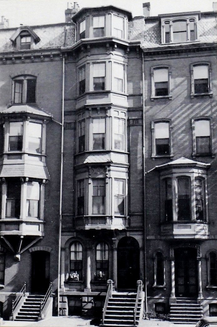
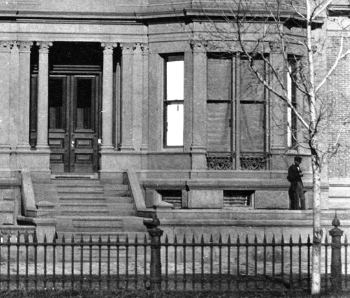
16 Marlborough (ca. 1942), photograph by Bainbridge Bunting, courtesy of the Boston Athenaeum
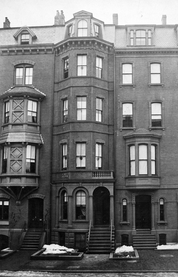
16 Marlborough (ca. 1869), detail from photograph courtesy of the Bostonian Society
In 1865, John Mixer built a house at 16 Marlborough which included a bay almost the entire width of the house with a porch extending to the west on the same plane as the front of the bay, topped with a balustrade. On the western side, the porch area extended out beyond the stairs of the neighboring house to the west at 18 Marlborough and had a window looking onto the neighbor’s stairs. In October of 1866, after unsuccessfully attempting to convince John Mixer not to build 16 Marlborough in this manner, the owners of 18 and 20 Marlborough — Miss Ann D. Torrey and her sister, Mrs. Sarah Parker (Torrey) Linzee — brought legal action to compel compliance with the deed restrictions by John Mixer and by Mrs. Marianne (Mason) Crafts, who had purchased the house by early 1866. In March of 1869, the Supreme Judicial Court agreed, ruling that “the plaintiffs are entitled to relief as prayed for” and sending the matter “to a master to consider and report in what form and manner the relief can be given with the least detriment to all parties in interest.” Ultimately, the front of the house was rebuilt. Linzee v Mixer (101 Mass. 512).
17 Commonwealth (ca. 1870), showing extension to right of stairs, with man standing on it; detail from photograph by Frederick M. Smith, II; courtesy of the Print Department, Boston Public Library
In 1866-1867, William Howard Gardiner built a house at 17 Commonwealth, the front wall of which was set back the required distance from the street but which also included in front of the house a structure three and one-half feet high, extending from the front wall of the house to the street, the top of which was covered by turf and the interior used for coal bins. After complaints from the abutters, in June of 1867, he was requested by the Commissioners on Public Lands to remove the structure extending into the reserved area or otherwise make it conform with the deed restrictions. He did not do so, and In August of 1867, the Attorney General filed legal action. In May of 1875, the Supreme Judicial Court ruled that “so much of it as rises above the usual line of the reserved spaces in front of the houses on Commonwealth Avenue must therefore be removed within a reasonable time.” Attorney General v. William H. Gardner (117 Mass. 492).
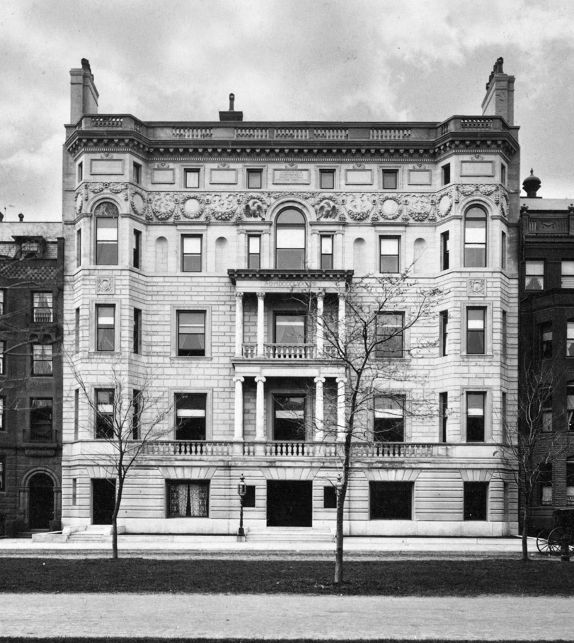
217 Commonwealth (ca. 1888), courtesy of the Boston Public Library, Print Department
In 1887-1888, the Algonquin Club built its clubhouse at 217 Commonwealth, the street level story of which projected across the entire front of the building, connecting the area between the bays the east and west ends of the building with the central portico. This street level was one story high, with balustrades above to create a balcony accessible from the first floor stretching across the center of the building, between the two flanking bays. In September of 1887, the Harbor and Land Commission informed the Club of this violation, but it proceeded to complete the building without change. In June of 1888, the Attorney General filed legal action to secure the Club’s compliance.

217 Commonwealth (2012)
In a December 10, 1889, article commenting on the pending litigation, the Boston Globe observed that “the members of the club are much disturbed over this menace to their beautiful building…the remodeling…will not only cost considerable money, but will ruin the design.”
On April 1, 1891, the Supreme Judicial Court ordered that the building be remodeled to comply with the deed restrictions (Attorney General v Algonquin Club; 153 Mass 447). After efforts to secure legislation deeming it “inexpedient to enforce” the court’s decision and further appeals by the Club, the full bench of the Supreme Court ruled on December 4, 1891, that the front of the building would have to be altered to comply with the deed restrictions (Attorney General v Algonquin Club; 155 Mass 155). The front of the building subsequently was rebuilt accordingly.
Not every complaint that a structure encroached into the reserved setback was resolved against the building owner, as complaints involving 26 Exeter and 176–178 Commonwealth illustrate.
26 Exeter (ca. 1885), detail from photograph by F. A. Tremaine, showing porch on Newbury façade; Ryerson and Burnham Archives, The Art Institute of Chicago (Digital file #43950).
In 1883-1885, Marcellus Seth Ayer, on behalf of the Working Union of Progressive Spiritualists, built the First Spiritual Temple at 26 Exeter. It included a stone porch on the Newbury Street façade, at the east end of the building, with solid walls projecting at right angles to the front wall into the reserved setback area. The Harbor and Land Commissioners brought legal action to compel removal of the porch. At issue was whether a porch qualified within the meaning of the term “portico and other usual projections” as used in the deed restrictions. In February of 1889, the Supreme Judicial Court dismissed the complaint, concluding that the meanings were sufficiently consistent and that the permission to construct projections into the reserved area “extends to more serious structures, with closed sides, and therefore there is no reason for excluding porches.” Attorney General v Marcellus S. Ayer and others (148 Mass. 584).
In 1883-1884, Dr. James Batchelder Bell and Dr. William Palmer Wesselhoeft built houses at 176 and 178 Commonwealth, a symmetrical pair, 176 Commonwealth with a bay on the west and 178 Commonwealth with a bay to the east. Each house had two front entrances, one on the outer side of the front façade, for use by the residents, and the other on the inner side, where the two houses joined, for use by patients. The porches to the entrances were enclosed and fronted with three arches (the two entrances to the medical offices sharing the center porch and arch) with windows in the bays between the arches, creating a continuous plane across the entire front of the two buildings, similar in appearance to the Algonquin Club design rejected by the court in 1891.
176-178 Commonwealth (ca. 1885); Soule Photograph Company, courtesy of Historic New England
In the early 1890s, Dr. Henry Orlando Marcy purchased 180 Commonwealth and in October of 1893, he filed a complaint alleging that 176-178 Commonwealth improperly encroached on the reserved area. In 1894, the Harbor and Land Commissioners ruled that it did not and that the houses did not need to be modified. The Commissioners concluded that each arched entrance was an allowed portico within the meaning of the deed restrictions (unlike the original design of the Algonquin Club, where the structures between the bays did not serve as an entrances), The Commissioners noted that the concern about 176-178 Commonwealth arose only because they each had two entrances, and “if the doors to the doctors’ offices did not exist, and the projections over them, being no longer porticos, were removed, the nature of the construction would resemble that of a large number of houses on the Back Bay on land similarly restricted.” They concluded that nothing in the deed restrictions prevented a house from having two entrances and “if a house has two front doors, there must be a right to have a portico over each, so that the extension of the projections along the whole front of the building by the conjunction of the bay window with the two porticos may be said to be an incidental result of the exercise of a permission expressly given.” The Attorney General subsequently concurred with this conclusion and no further action was taken.
Passageways (Alleys) In the Back Bay
The third area of conflict was the extent to which the deed restrictions requiring that the passageways be “kept open and maintained by the abuttors (sic) in common” prevented bay windows and other projections into the passageways (alleys). This issue was raised primarily in the non-residential portion of the Back Bay, but nevertheless had implications for the entire neighborhood.
The rules promulgated by the Commissioners on Harbors and Lands in 1883 augmented the deed provision to specify “No part of the building can project into or over this passage-way. The passage-way must be kept open its full width from the ground up to the sky.”
In 1884, Henry Bigelow Williams began construction of the Hotel Kensington at the northeast corner of Boylston and Exeter, and proposed to install bay windows projecting into the alley behind the building. In April of 1884, the Commissioners notified Mr. Williams that the windows would violate the deed restrictions. He proceeded to construct the windows and in May of 1884, the Attorney General filed legal action to compel removal of the windows. In June of 1885, the Supreme Judicial Court found that “a passageway sixteen feet wide was not merely to be kept open at the ends, but open to the sky throughout its entire length, for the general convenience and benefit,” and ordered that the bay windows be removed. Attorney General v Henry Bigelow Williams (140 Mass. 329).
In 1906-1907, 73 Newbury was rebuilt, the rear of the building was extended to the alley, and a fire escape was installed on the rear façade. Twenty-two property owners petitioned the Harbor and Land Commission to require that the fire escape be removed because it constituted an obstruction to the alley in violation of the deed restrictions. When the Commission failed to act, the property owners brought suit and on October 15, 1909, the Supreme Judicial Court ordered that the fire escape be removed.
Commercial Uses
The deeds issued by the Commonwealth and by the Boston Water Power Company specified that the land “shall not, in any event, be used … for any mechanical or manufacturing purposes,” and the deeds issued by the Boston and Roxbury Mill Corporation generally specified that the land would be used only for “dwelling houses.” In addition, the Commonwealth’s deeds for land on Commonwealth Avenue (but not the Boston and Water Company’s deeds) also prohibited the use of the land for “mercantile” as well as “mechanical or manufacturing purposes.”
In 1886, Doe, Hunnewell & Co., furniture dealers, leased space at 4 Arlington for their store. Residents expressed concern about the effect on the neighborhood of allowing a commercial use on Arlington, predicting that they soon would extend throughout the neighborhood. The deed restrictions did not prohibit “mercantile” uses on Arlington, however, and the lease was therefore valid. As anticipated, additional commercial uses soon appeared on other Back Bay streets, and notably on Newbury.
By 1890, Galvin Bros. florists, located at 124 Tremont, had opened a store in the basement of the Hotel Vendome on Commonwealth. In December of 1893, residents filed a complaint with the Harbor and Land Commissioners. In April of 1894 the Commissioners concluded that the business violated the restriction on “mercantile” uses on Commonwealth Avenue, and the shop was closed.
It appears that there had been at least one prior example of mercantile activity on Commonwealth. In its May 11, 1894, article on the closure of Galvin Bros., the Boston Herald commented that “the withdrawal of Galvin Bros. from Commonwealth avenue relieves this prominent thoroughfare of stores of any kind, the only other place occupied for mercantile purposes having been ordered vacated by the harbor and land commissioners some months ago.” The Commissioners’ 1893 and 1894 Annual Reports do not mention any such action; however, the 1893 report does note that “several complaints in regard to alleged violations of restrictions in the deeds of the Commonwealth” had been received, but “in most of the cases notice of the complaint has resulted in the removal of the features principally objected to, and no action on the part of the Board has become necessary.”
