274 Marlborough and 16-18-20 Fairfield were built on a parcel of land originally purchased from the Boston Water Power Company on February 16, 1863, by Daniel Davies, Jarvis Dwight Braman, and Grenville Temple Winthrop Braman (Suffolk Co. Deed Registry, Book 826, p. 86). It was one of four parcels purchased by Daniel Davies and his partners at the same time. The parcels were at the west end of the block between Exeter and Fairfield, on the south side of Beacon, the north and south side of Marlborough, and the north side of Commonwealth.
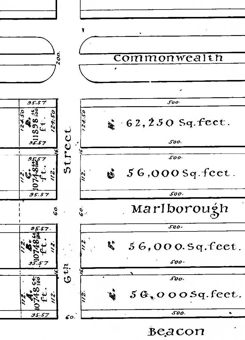
Detail from plan by J. F. Fuller, showing land purchased by Daniel Davies et al (Suffolk Co. Deed Registry, Book 826, p. 87; 25Feb1863)
The blocks between Exeter and Fairfield are 600 feet in length. The boundary between the lands owned by the Commonwealth of Massachusetts on the east and the lands owned by the Boston Water Power Company on the west was located at a point about 505 feet west of Exeter. The land purchased by Daniel Davies and his partners included all of the Boston Water Power Company’s land between the boundary on the east and Fairfield on the west (shown on the plan as Lots A, B, C, and D, east of “6th Street”).
In its deed conveying the land, the Boston Water Power Company stated that the distance from the boundary to Fairfield was 95.57 feet. In its deeds for the parcels to the east, the Commonwealth calculated the distance from Exeter to the boundary as being 504.8 feet, leaving 95.20 feet to Fairfield, a discrepancy of 0.37 feet (4½ inches).
On December 30, 1868, Daniel Davies and his partners sold their parcels on the south side of Marlborough and the north side of Commonwealth to Henry N. F. Marshall. On February 25, 1869, he sold both parcels to James C. White, and on June 29, 1869, James White sold both parcels to Dr. Horatio R. Storer.
On October 1, 1872. Franklin Evans purchased the parcel on the south side of Marlborough was purchased from Horatio Storer.
Franklin Evans died in January of 1874. On June 11, 1875, his widow, Carrie (Ellis) Evans, sold lot at the corner of Fairfield and the alley, with a frontage on Fairfield of 20 feet and a depth of 71.57 feet, to Francis Richmond Allen.

Plan by Henry W. Wilson, 1Jan1876 (Suffolk Co. Deed Registry, Book 1321, p. 76)
Franklin Evans had an agreement with Charles U. Cotting of Brookline that they would share equally in the profits and losses from their land investments, and on January 12, 1876, the Norfolk County Probate Court approved a settlement (Book 1321, p. 72) under which Franklin Evans’s holdings were divided between Charles Cotting and Carrie Evans.
Under the agreement, the parcel at the western end of Marlborough was subdivided into five lots: one lot on the eastern end of the parcel with a 24 foot frontage on Fairfield and depth of 112 feet, and four lots facing Fairfield with a depth of 71.57 feet (east-west), including the lot already sold to Francis Allen. Carrie Evans retained the proceeds from the sale of the lot to Francis Allen (Lot 5) and received the lot north of it (Lot 4) with a 19 foot frontage on Fairfield and the lot with a 24 foot frontage on Marlborough (Lot 1). Charles Cotting received the remaining lots facing Fairfield (Lots 2 and 3), with a combined frontage of 69 feet. He transferred the property to his wife, Susan Cordelia (Delano) Cotting on April 21, 1877.
The plan filed in conjunction with the settlement indicated the northern and southern boundaries of the parcel as 95.57 feet, consistent with the Boston Water Power Company’s calculations. These measurements were reflected in subsequent deeds conveying the land at 16 Fairfield (Book 1372, p. 58; 19Apr1877), 18 Fairfield (Book 1416, p. 1; 15Apr1878), and 20 Fairfield (Book 1274, p. 89; 11Jun1875). However, when Carrie Evans sold the land at 274 Marlborough to Charles Wood’s trust (Book 1457,p. 291; 21May1879), the deed indicated the northern and southern boundaries as being 23.63 feet (rather than 24 feet, as shown on the 1876 plan), consistent with the Commonwealth’s calculations. At the same time, Susan Cotting conveyed to Charles Wood’s trust a 0.37 foot strip of land 64 feet wide at the eastern boundary of her land at 16 Fairfield (Book 1457, p. 292; 22May1879), thereby increasing the width of the lot at 274 Marlborough to 24 feet for about half of its length.
When 274 Marlborough was sold by Charles Wood’s trust to William Gannett (Book 1873, p. 245; 25Apr1889), the deed included two parcels, the original lot as conveyed by Carrie Evans, with northern and southern lines of 23.63 feet, running the entire 112 foot depth, and the second lot conveyed by Susan Cotting, with northern and southern lines of 0.37 feet, running south 60 feet.
Carrie Evans had died in March of 1883, and in conjunction with the sale to William Gannett, her executor entered into an agreement (Book 1873, p. 247; 5Apr1889) with the owners of 272 Marlborough affirming that the boundary between their properties was 92.20 feet and waiving any claim to the 0.37 feet east of that line.
Although the 1879 deed from Susan Cotting had resolved the 0.37 foot discrepancy for the northern 60 feet of 274 Marlborough, there remained a 0.37 foot discrepancy for the rest of the lot, a strip running 52 feet, 9 feet behind 16 Fairfield and 43 feet behind 18-20 Fairfield. Subsequent deeds conveying 18-20 Fairfield continued to indicate the northern and southern boundaries as 71.57 feet.
William Gannett died in April of 1929, and when his widow sold 274 Marlborough (Book 6391, p. 310; 10Dec1947), the deed stated the northern and southern lines to be 24 feet, running the entire distance of the lot. Subsequent deeds for 274 Marlborough continued to indicate these boundaries and do not reconcile the discrepancy.
