In 1852, the Massachusetts legislature (Chapter 79, Resolves of 1852) established the Commissioners on Boston Harbor and the Back Bay “to determine and settle, by agreement, arbitration or process of law,” the disputed claims to the tidal lands of the Back Bay and to “devise or adopt a plan for changing the use of the said lands and flats, or any part thereof, from mill purposes to land purposes, and for filling up and improving the same, for building lots.”
On June 9, 1854, the Commonwealth entered into indentures with the Boston and Roxbury Mill Corporation and its subsidiary, the Boston Water Power Company, under which the tidelands were allocated between the two companies and the Commonwealth. Those agreements were subsequently modified by additional agreements in 1856 between the Commonwealth, the Boston Water Power Company, and the City of Boston.
Click here for additional information on the development of the Back Bay, and click here for additional information on the Back Bay lands held by the Commonwealth of Massachusetts, the Boston and Roxbury Mill Corporation, and the Boston Water Power Company.
A portion of the tidal lands in the Back Bay were held by private owners, and, of those, the lands in what would become the residential portion of the neighborhood were held entirely by the David Sears family.
The Sears family lands extended south from a line down the middle of Commonwealth, bounded on the east by the Commonwealth’s lands (the boundary was 262 feet west of Exeter, at about where the western wall of 214 Commonwealth is today) and bounded on the west by the Boston Water Power Company’s lands, by a line that ran southwest at approximately a 45 degree angle from a point on the south side of Commonwealth 134.66 feet west of Hereford (324 Commonwealth straddles the line). The Sears family land extended south by an irregular line past Boylston to about St. James Street.
The map below illustrates the lands owned by the Sears family, the Commonwealth, the Boston Water Power Company, and the Boston and Roxbury Mill Corporation, drawn on the block plan for the residential portion of the neighborhood in 2015.
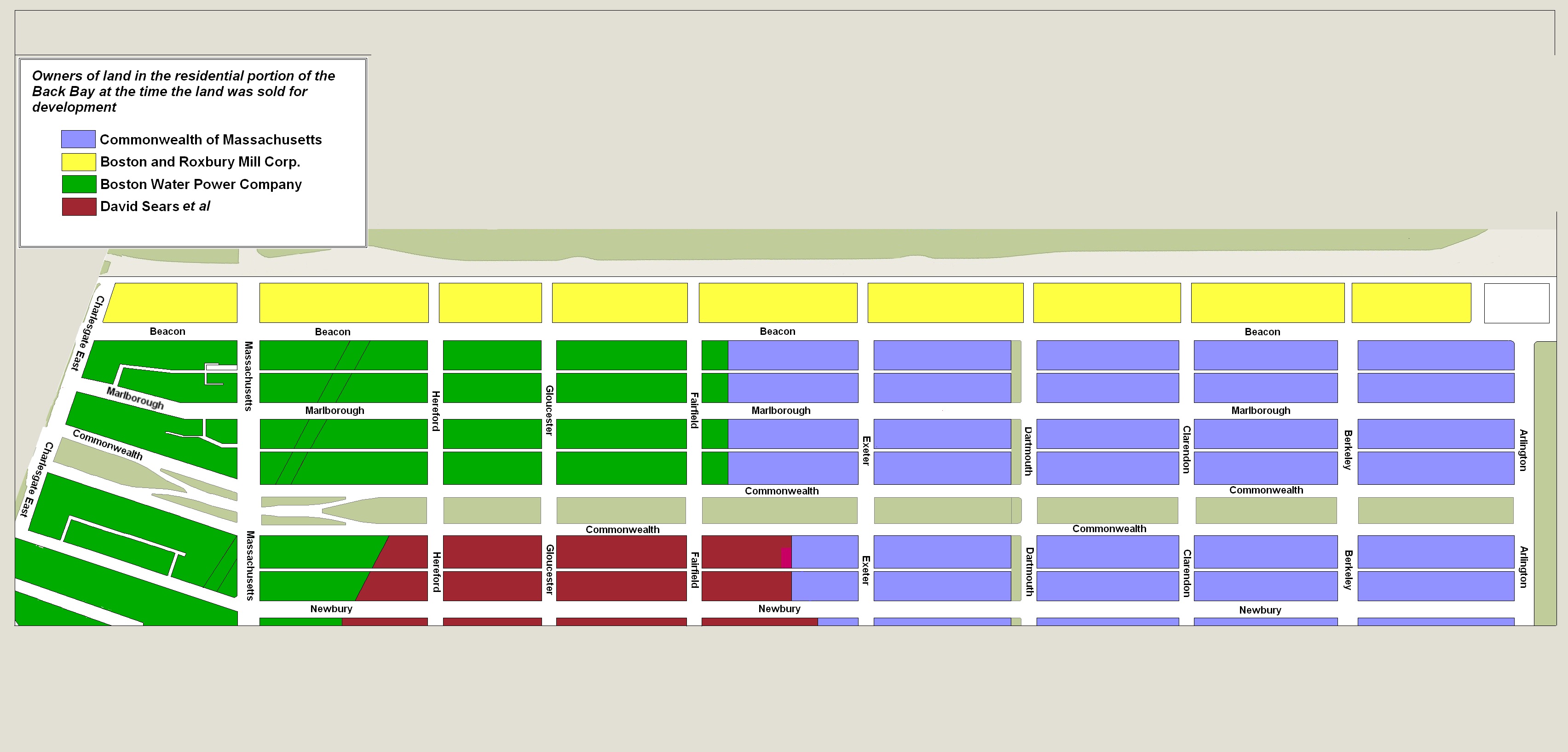
Original owners of Back Bay, shown on 2015 block map
David Sears had been an early advocate of converting the tidelands into buildable land, and in 1849, he proposed a plan to create a large oval lake in the middle of the area, to be called “Silver Lake.”

Plan for the Back Bay by David Sears, 1850; courtesy of the Norman B. Leventhal Map Center at the Boston Public Library
The original proposal would have provided a 75 acre lake, with the eastern shore at about where Berkeley Street later was laid out. “Sears Avenue” would have run along the south shore, and an unnamed boulevard would be laid out around the remainder of the lake. He revised the plan in 1850 and in subsequent proposals, reducing the size the 37½ acres (with a one mile circumference) and eliminating “Sears Avenue,” and pursued it for about ten years in various iterations.
In their Boston’s Back Bay, William A. Newman and Wilfred W Holton note that the Sears proposal was rejected repeatedly by the Commonwealth, with the Commissioners on the Back Bay concluding that the proposal and the associated conditions proposed by Sears “were only to his benefit and would greatly reduce the amount of valuable land to be sold by the State.”
On February 10, 1859, David Sears transferred to his three sons – David Sears, jr., Frederic Richard Sears, and Knyvet Winthrop Sears – “all my land and flats at Gravelly Point in the City of Roxbury and all my lands and flats on the Back Bay…meaning to convey all my lands and flats in the full and receiving basins of the Boston Water Power Company, whether the same be found within the present limits of the City of Roxbury or within the present limits of the City of Boston” (Suffolk Co. Deed Registry, Book 819, p. 233).
On January 2, 1871, David Sears, jr., Frederic Sears, and Knyvet Sears sold all of Sears family land in the Back Bay to Nathan Matthews (Book 1029, p. 233). David Sears, Sr., died later that month.
Nathan Matthews was a real estate investor and developer, and served as president of the Boston Water Power Company from 1860 to 1870. He and his wife, Albertine (Bunker) Matthews, lived at 12 Arlington.
Immediately upon acquiring the property, Nathan Matthews conveyed the land on the south side of Commonwealth and north side of Newbury between the boundary with the Commonwealth’s lands and where Fairfield Street would later be laid out to Franklin Haven (Book 1029, p. 239); and conveyed his remaining land on the south side of Commonwealth and the north side of Newbury between Fairfield and the Boston Water Power Company boundary to David Nelson Skillings, trustee (Book 1029, p. 238).
David Skillings and his wife, Mary (Maguire) Skillings, lived in Winchester. He was acting as trustee for a real estate investment trust composed of himself, Lawrence Barnes (of Burlington VT), Charles Whitney (of Lowell), and David Whitney, Jr. (of Detroit). All four were lumber dealers. The trust also had purchased all of the Boston Water Power Company’s land running west from the boundary with the Sears family land to Massachusetts Avenue.
On February 8, 1871, Franklin Haven conveyed the land east of Fairfield back to Nathan Matthews (Book 1034, p. 56), and Nathan Matthews transferred it to David N. Skillings, trustee (Book 1034, p. 84).
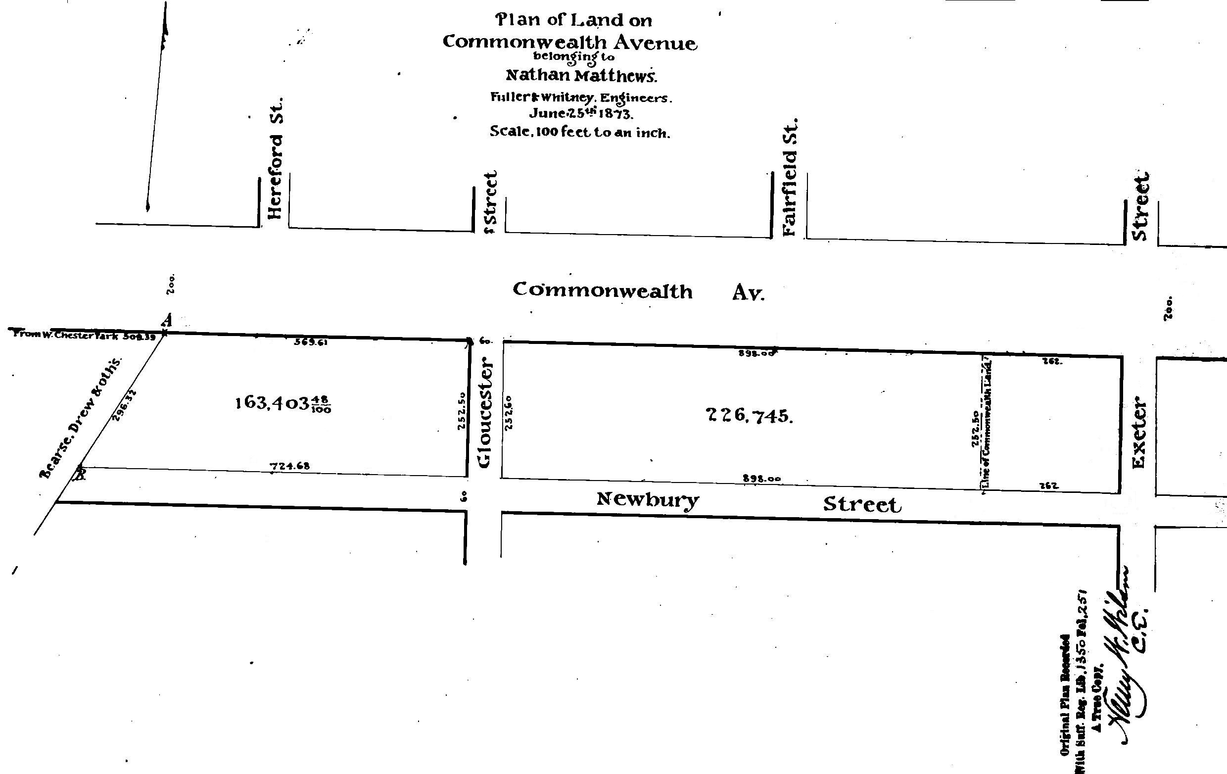
Plan of Land owned by Nathan Matthews; Fuller & Whitney, 25Jun1873 (Suffolk Co. Deed Registry, Book 1350, p. 251).
On May 30, 1873, David N. Skillings sold all of the land back to Nathan Matthews. As shown on the plan to the left, the land included the 60 foot wide parcels where Fairfield and Hereford Streets later would be laid out between Commonwealth and Newbury.
On October 16, 1873, Nathan Matthews conveyed the land to a trust he had formed with Henry D. Hyde and Grenville T. W. Braman. The transfer was made through attorney Harvey N. Shepard (Book 1182, p. 270) who conveyed it on the same day to the trustees (Book 1182, p. 271). Under the terms of the trust (Book 1298, p. 219) ownership of the land was held in the following proportions: Nathan Matthews, 8/12ths; G. T. W. Braman, 22/120ths; Jarvis Braman (Grenville Braman’s brother), 9/120ths; and Henry D. Hyde, 9/120ths.
Grenville Temple Winthrop Braman was a real estate investor and served as treasurer of the Boston Water Power Company until mid-1869 (at the same time as Nathan Matthews was president). He and his wife, Susie A. (Davies) Braman, lived at 9 Brimmer and later at 447 Beacon. Henry Dwight Hyde was an attorney. He and his wife, Luvan Augusta (Charles) Hyde, lived at 153 West Newton and later at 380 Commonwealth.
On November 19, 1875, Nathan Matthews and his partners terminated the trust and conveyed the land back to Harvey N. Shepard (Book 1303, p. 157), who distributed it to individual owners.
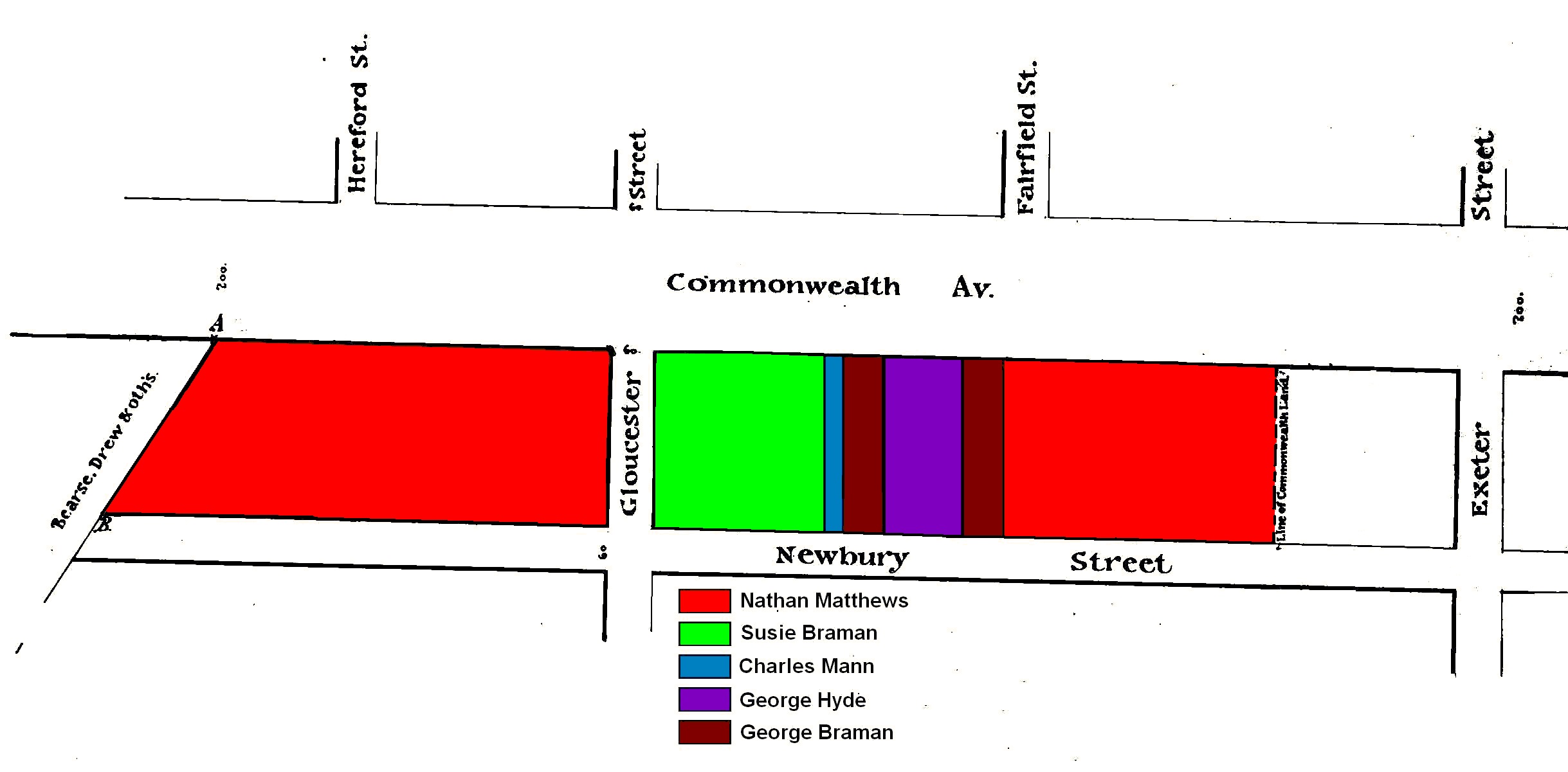
Owners of former Sears family land as of November 19, 1875, drawn onto 1873 plan by Fuller & Whitney
Nathan Matthews received two parcels (Book 1303, p. 207): the land from the boundary with the Commonwealth to Fairfield, with a frontage of 398 feet on the south side of Commonwealth and the north side of Newbury, and the land from Gloucester to the boundary with the Boston Water Power Company lands, with a frontage of 569.61 feet on the south side Commonwealth and 724.68 feet on the north side of Newbury. The former parcel included the 60 foot wide strip where Fairfield later would be located, and the latter parcel included the 60 foot wide strip where Hereford Street later would be located.
The block between Fairfield and Gloucester was divided among four owners. The western half, with frontages of 250 feet on the south side of Commonwealth and north side of Newbury, was conveyed to Susie A. (Davies) Braman, the wife of Grenville T. W. Braman (Book 1303, p. 157). The eastern half of the block was allocated among three owners. The 56.5 foot parcel at the corner of Fairfield was conveyed to Grenville T. W. Braman’s brother, George H. Braman (Book 1303, p. 158); the 112.5 foot parcel to the west of it was conveyed to Henry D. Hyde’s uncle, George Baxter Hyde (Book 1303, p. 159); the 56 foot parcel next to the west was conveyed to George H. Braman (Book 1303, p. 157); and the 25 foot lot next to that was conveyed to Charles H. Mann (Book 1303, p. 158).
George H. Braman was a wholesale dry goods merchant. He and his wife, Ellen S. (Hunnewell) Braman, lived in Charlestown. George Baxter Hyde was headmaster of Everett School. He and his wife, Mary Wilbur (Clapp) Hyde, lived at 141 Worcester. Charles H. Mann was agent for the Waltham Bleachery and Dye Company. He and his wife, Emily Sprague (Cushman) Mann, lived at the Parker House hotel in Boston. Unlike the other grantees of land on the block, neither Charles Mann nor his wife appear to have been related to Nathan Matthews, Henry D. Hyde, or Grenville T. W. Braman.
Exeter to Fairfield. On May 18, 1876, Nathan Matthews sold his eastern parcel to the National Bank of Commerce of Boston (Book 1329, p. 62), including the land running west 358.75 feet from the boundary with the Commonwealth’s land on the south side of Commonwealth and the north side of Newbury. On June 28, 1878, William O. Grover, who held a mortgage on the parcel, foreclosed and sold his interest to the National Bank of Commerce (Book 1427, p. 49).
The bank subsequently sold its land, and buildings were constructed on the block between 1879 and 1889.
Fairfield Street Extension. The land that Nathan Matthews sold to the National Bank of Commerce included 20.75 feet of the eastern side of what would become the extension of Fairfield Street between Commonwealth and Newbury. It was acquired by the City of Boston on April 29, 1878, for that purpose (Book 1417, p. 132).
On June 2, 1876, Nathan Matthews sold the Boylston National Bank the land comprising the western side of what would become the extension of Fairfield Street (Book 1417, p. 133), with a width of 39.3 feet. The it was acquired from the bank bank by the City of Boston on April 26, 1878 (Book 1417, p. 133).
Fairfield to Gloucester. As of November of 1875, the block between Fairfield and Gloucester was owned by George H. Braman, George Baxter Hyde, Charles H. Mann, and Susie A. (Davies) Braman, the wife of Grenville T. W. Braman. They subsequently sold the land and buildings were constructed between 1876 and 1896.
Gloucester to Boston Water Power Company Boundary. On June 2, 1876, Nathan Matthews subdivided his western land, running from the west side of Gloucester to the former boundary with the Boston Water Power Company.

Owners of former Sears family land west of Gloucester as of June 1876, drawn onto 1873 plan by Fuller & Whitney
He sold the Boylston National Bank the eastern portion (Book 1329, p. 38), a parcel at the southwest corner of Gloucester with a frontage of 74.75 feet on the south side of Commonwealth and the north side of Newbury (as noted above, in the same transaction, he also sold the bank the western side of what would become the extension of Fairfield Street).
Nathan Matthews sold Edwin Pope (Book 1329, p. 39) a parcel to the west of the land he sold to the bank, with a frontage of 38 feet 7½ inches. And he sold Caleb H. Warner and Charles F. Smith (Book 1329, p. 63) a parcel to the west of that, with a frontage of 411 feet 10½ inches. The parcel purchased by Caleb Warner and Charles Smith included the western 261 feet 7½ inches of the block between Gloucester, and Hereford, the 60 foot wide parcel where Hereford Street later would be located, and eastern 90 feet 3 inches of the block between Hereford and Massachusetts Avenue.
Nathan Matthews retained the remainder of the land further west, between the land he sold to Caleb Warner and Charles Smith and the former boundary with the Boston Water Power Company lands. The boundary ran southwest at approximately a 45 degree angle, starting on the south side of Commonwealth at a point 134.66 feet west of Hereford. The frontage on the south side of Commonwealth was 44.75 feet and the frontage on Newbury was 199.77 feet.
All of the land sold by Nathan Matthews on June 2, 1876, and the parcel he retained, were subject to a mortgage held by David Skillings. On October 21, 1876, he foreclosed on the mortgage and sold his interest in the property to Albert J. Fernald (Book 1350, p. 250).
On the same day, Albert Fernald sold the Boylston National Bank (Book 1350, p. 252) his interest in the two parcels the bank had purchased from Nathan Matthews, and he sold Edwin Pope (Book 1350, p. 253) his interest in the parcel he had purchased from Nathan Matthews.
On October 22, 1876, Albert Fernald sold John Worster (Book 1396, p. 196) the lot furthest west, running to the former boundary with the Boston Water Power Company lands, that had been retained by Nathan Matthews.
And on October 23, 1876, Albert Fernald sold Edwin Tufts (Book 1360, p. 188) his interest in the 411 foot 10½ inch parcel that Caleb Warner and Charles Smith had purchased from Nathan Matthews. On January 4, 1877, Edwin Tufts conveyed his interest in the parcel to Caleb Warner and Charles Smith (Book 1362, p. 133). In a declaration dated May 27, 1878 (Book 1420, p. 282) Caleb Warner and Charles Smith stated that they owned the parcel as trustees acting for the benefit of the holders of notes (bonds) issued by Nathan Matthews under an indenture dated February 2, 1876, and that Edwin Tufts had transferred his interest in the property to them at Nathan Matthews’s behest for the purpose of selling it and using the proceeds to reduce his indebtedness under the notes.
Hereford Street Extension. On March 28, 1878, Caleb Warner and Charles Smith sold the City of Boston the 60 foot wide parcel for the extension of Hereford Street from Commonwealth to Newbury.

Owners of former Sears family land west of Gloucester as of June 1878, drawn onto 1873 plan by Fuller & Whitney
Gloucester to Hereford. As of June 1878, the land on the south side of Commonwealth between Gloucester and Hereford was owned by the Boylston National Bank, Edwin Pope, and Caleb Warner and Charles Smith, as trustees. They subsequently sold the land, and buildings were constructed between 1880 and 1896.
Hereford to Massachusetts Avenue. As of June 1878, the former Sears family land on the south side of Commonwealth between Hereford and Massachusetts Avenue was owned by Caleb Warner and Charles Smith, as trustees, and by John Worster. The former Boston Water Power Company land on the block was owned by David Skillings (who had acquired it in 1870 as a trustee, sold it to Horace Bearce and Ira Drew in 1873, and re-acquired it as an individual in 1878). They subsequently sold the land, and buildings were constructed between 1878 and 1899.
