
Map of the Back Bay showing current streets, the 1630 shoreline, and the mill dam and cross dam; provided by MapWorks, as appeared in Boston’s Back Bay by William A. Newman and Wilfred E. Holton, p. viii (map copyright MapWorks 2005).
In 1814, the Boston and Roxbury Mill Corporation was authorized by the Massachusetts legislature to build a dam from the corner of Charles and Beacon Streets in the east to Sewall’s Point in the west (at what is today Kenmore Square), separating about 430 acres of tidal lands from the Charles River. A Cross Dam was built connecting with the Mill Dam at a point about 210 feet west of what is today Hereford and running southwest at approximately a 45 degree angle to Gravelly Point (at about what is today the intersection of Commonwealth and Massachusetts Avenues). The Cross Dam divided the tidal lands into two basins. A western basin (about where the Fenway neighborhood is today), called the Full Basin, and an eastern basin (about where the Back Bay neighborhood is today), called the Receiving Basin. Water was allowed to flow into the Full Basin from the river at high tide, then into the Receiving Basin and then back into the river at low tide. The tidal flows were used to power mills and other industrial businesses.
The Boston and Roxbury Mill Corporation built a toll road on top of the Mill Dam and opened it to travel in 1821. It was known alternatively as the Mill Dam Road or Western Avenue before it was accepted as an extension of Beacon Street by the City of Boston.
A road also was built on top of the Cross Dam and named Parker Street. Parker Street intersected the south side of Beacon Street between what are now Hereford Street and Massachusetts Avenue (at a point about 210 feet west of Hereford, about at the middle of where 451 Beacon later would be built), and ran southwest at approximately a 45 degree angle, intersecting Marlborough, Commonwealth, Newbury, and Boylston, and then continuing to Centre Street.
Various manufacturing and industrial businesses were located on the Mill Dam Road and on Parker Street to utilize the tidal power provided by the dam.
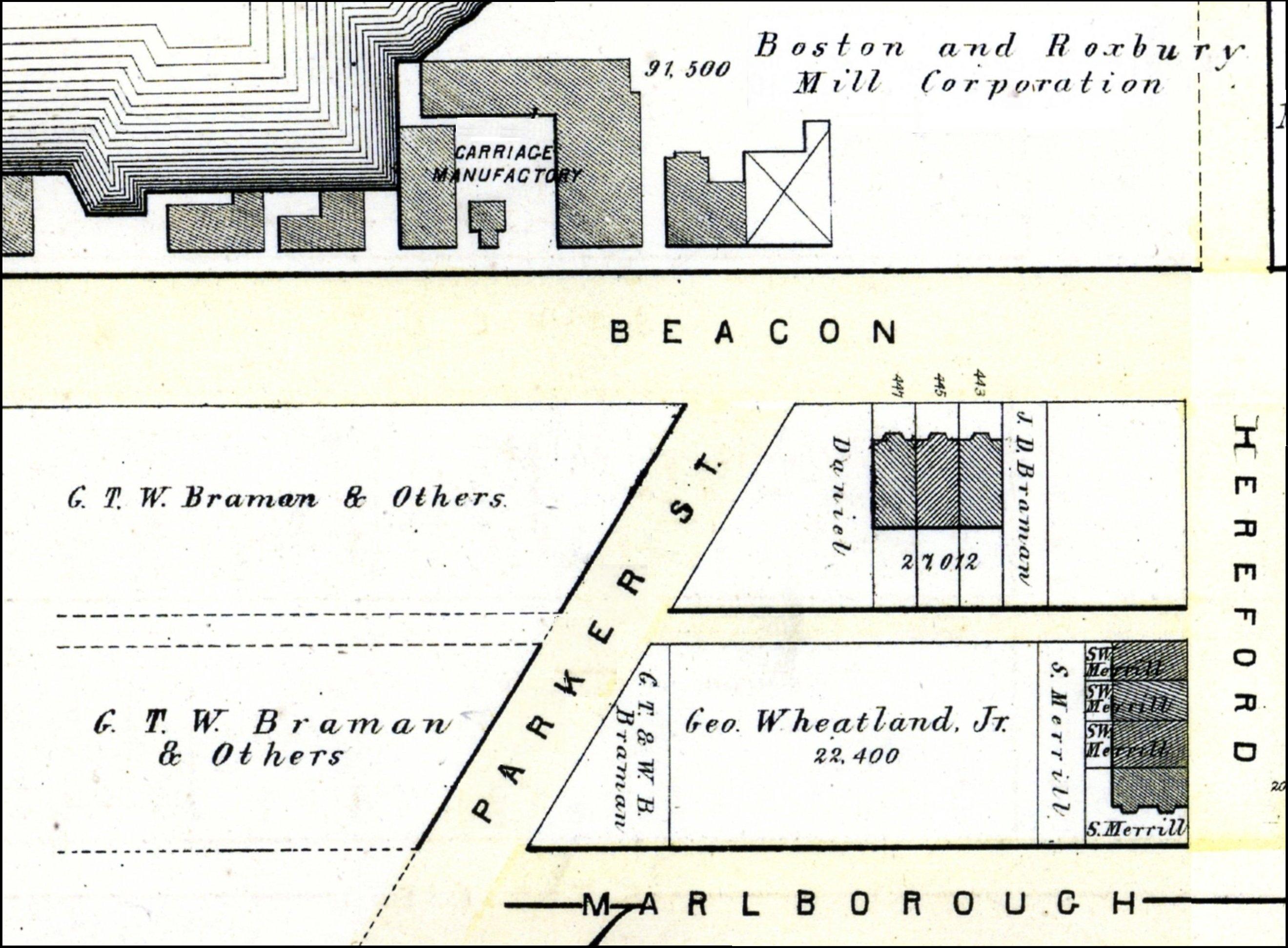
1874 Hopkins map, showing the structures on the north side of Beacon opposite Parker Street
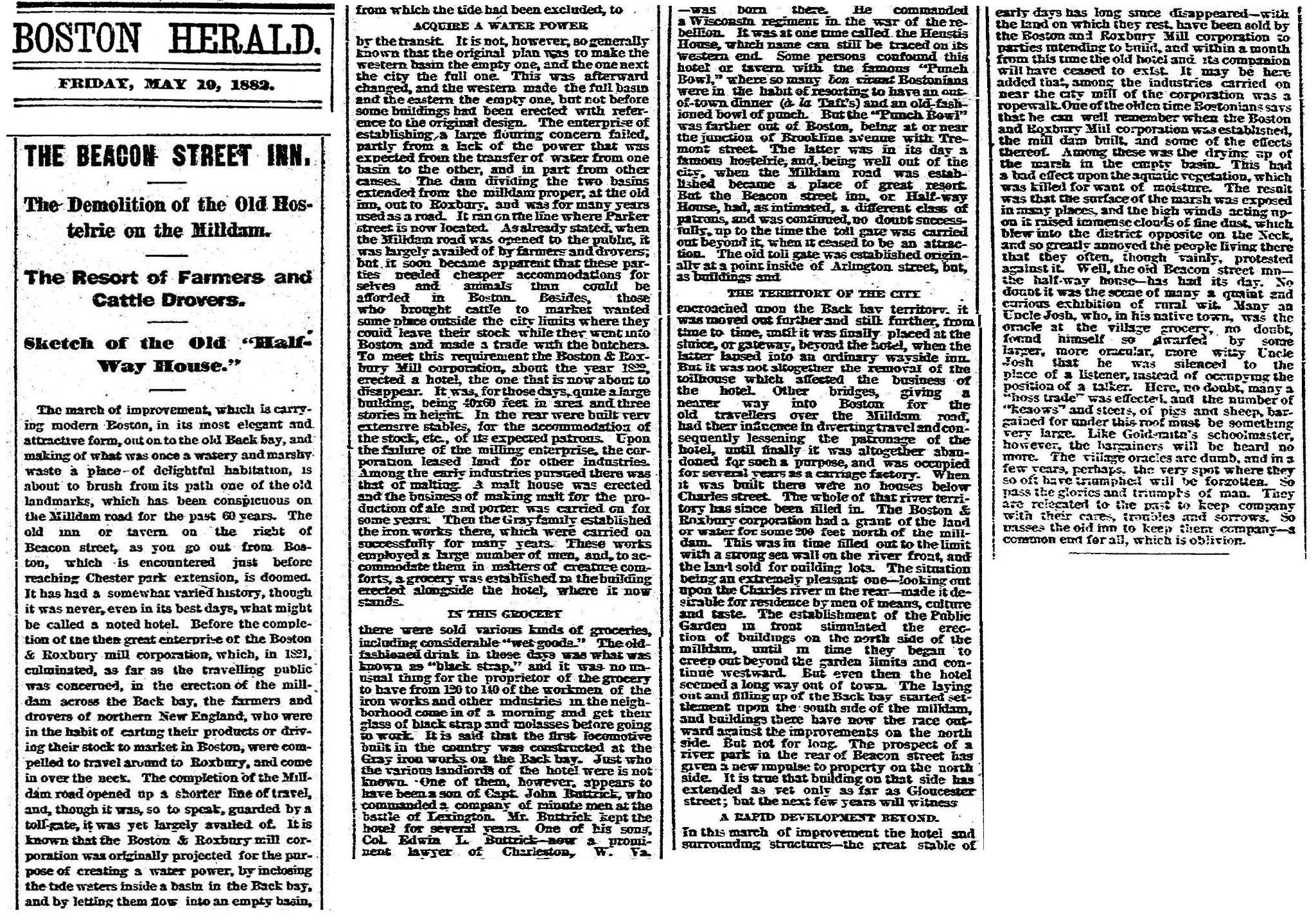
On the north side of the Mill Dam Road (Beacon) across from Parker Street, a hotel and large stable were built in about 1822, not long after the Mill Dam was completed. Known as Huestis House and later as the Mill Dam Hotel, and sometimes called the Half-Way House, it was built by the Boston and Water Power Corporation primarily to serve farmers and drovers who were bringing their goods to market, using the newly-completed Mill Dam road. Over the years, houses and apartment buildings, a malt house, an iron foundry, and a building used for carpet cleaning were built on the land west of the hotel and leased from the corporation. In about the late 1860s, the hotel ceased to operate and by 1869, it was used as a carriage building factory and apartments.
Boston’s first primary school was located on the south side of the Mill Dam Road (Beacon), a few feet west of Parker Street, built in 1831. A January 19, 1902, article in the Boston Globe describes the school as “25 feet square and two stories high,” constructed “on piles in the full basin of the Back Bay.” The school closed in 1861.
The portion of Parker Street between Beacon and Commonwealth was discontinued as a public thoroughfare in 1877, and soon thereafter the Boston and Roxbury Mill Corporation implemented plans to remove the structures on the north side Beacon. On April 29, 1881, it sold at public auction the stables building and nine residential buildings (three dwelling houses and six tenements), with the stipulation that they would be removed by the purchasers. The corporation retained the land. An April 30, 1881, Boston Daily Advertiser article on the sale noted that “the company will create some valuable house lots on this site … A little further to the east is an old building that will probably be removed in due season by the march of improvements; it was used for many years as a hotel, but at the present time the lower stories are devoted to the manufacture of carriages, while the upper portion is let for tenements.” A May 19, 1882, article in the Boston Herald, published when the former hotel was about to be demolished, discussed the hotel and neighboring businesses in some detail. Click here to read the article.
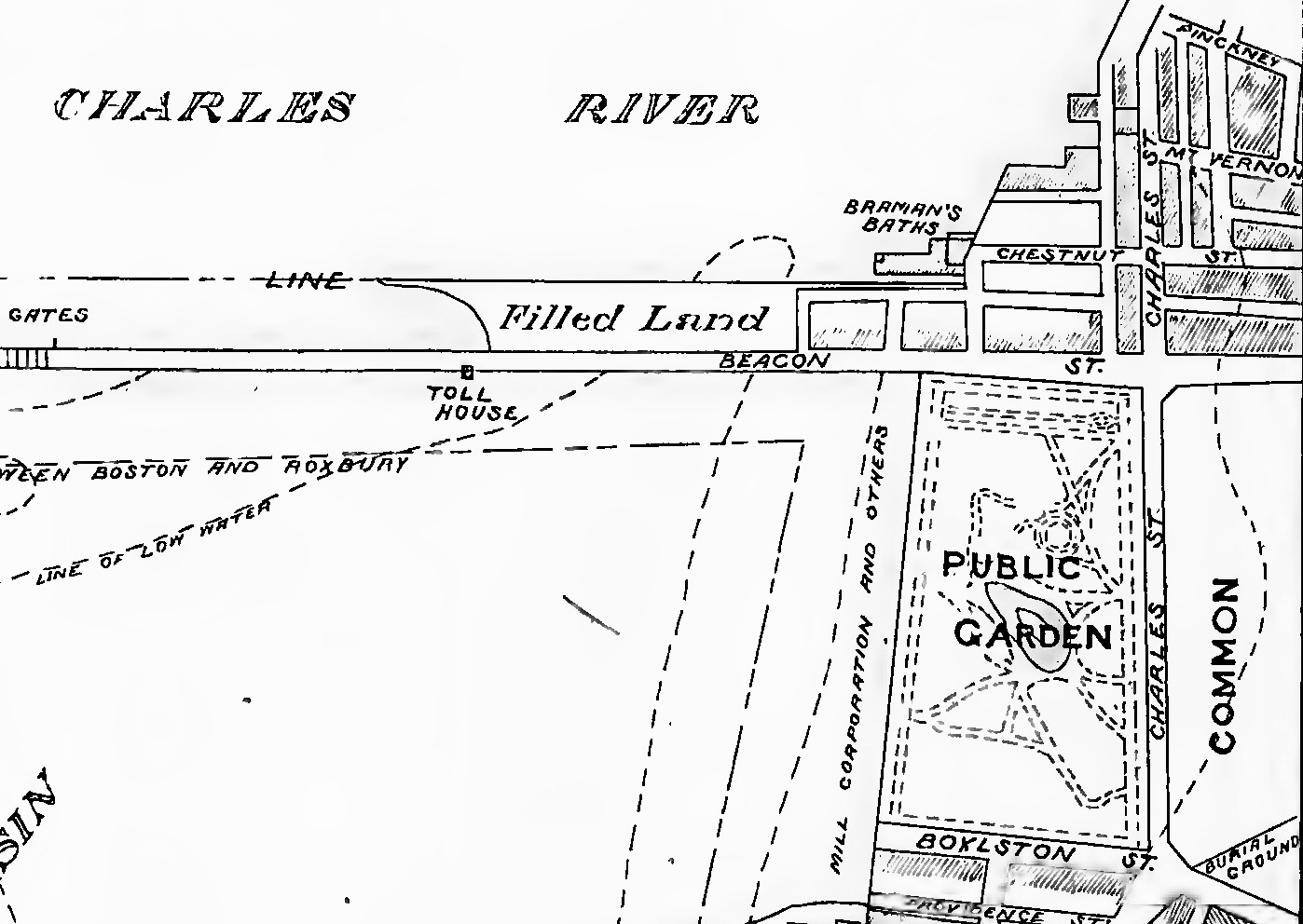
Detail from 1851 plan from the Back Bay; A Set of Plans Showing the Back Bay 1814-1881, by Fuller and Whitney
By 1851, the corporation had built a sea wall 200 feet to the north of dam west of Otter Street (later Short Side Road, then Embankment Road, and then David G. Mugar Way) to a point at about where Clarendon Street later would be located. The corporation filled the land between the dam and the sea wall but, as of 1854, no buildings had been constructed on the land.
On June 9, 1854, the Commonwealth of Massachusetts entered into an indenture with the Boston and Roxbury Mill Corporation under which the corporation received title to the tidal flats two hundred feet north of the Mill Dam, west of the area they had already filled. In exchange, the corporation agreed to extend the sea wall to what is now Kenmore Square, to fill the land, to release its claims to land south of the Mill Dam (including the land where Beacon Street was located), and to forego its right to collect tolls on the Mill Dam Road after May 1, 1863 (between May of 1863 and December of 1868, the Commissioners on Public Lands continued to collect tolls for the benefit of the Commonwealth; in December of 1868, Beacon Street was accepted by the City of Boston as a public way and all tolls ceased).
Soon after the indenture was agreed upon, the corporation began extending the sea wall, filling the land between it and the Mill Dam, with the southern 20 feet of land used to widen Beacon Street. The corporation subdivided the land into individual lots, all of which were 150 feet deep from Beacon, with a 30 foot wide passageway (Back Street) behind them between the lots and the sea wall.
The filling and the land sales generally progressed from east to west. The first lots sold were on the land previously filled by the corporation, between Otter and Clarendon. On January 1, 1855, George Hovey purchased the lot at the corner of Beacon and Otter, where 100 Beacon would be built, and Charles Fessenden purchased the lot next to it, where 102 Beacon would be built. The last lot was sold on May 3, 1892, to Eugene H. Fay at 482-490 Beacon.
The map below illustrates the progress of the sale of land on the north side of Beacon, based on the date of the deeds from the Boston and Roxbury Mill Corporation, and, below that, when buildings were first constructed on the original land.
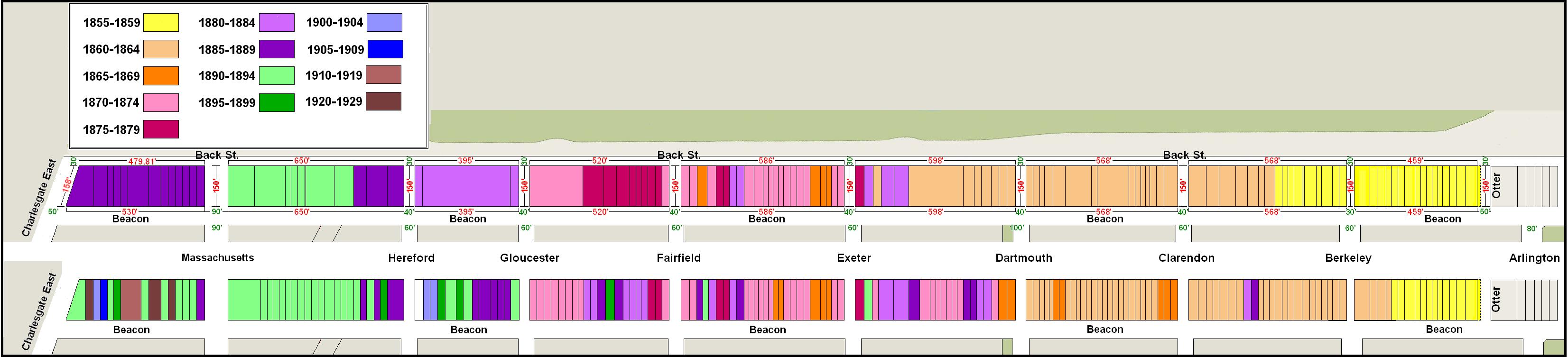
Original land purchases and original construction on the north side of Beacon
Initially, when it sold its land, the Boston and Roxbury Mill Corporation retained title to Back Street and the obligation to maintain the sea wall under its indenture with the Commonwealth. On December 31, 1869, the corporation transferred to each lot owner to whom it had sold land his or her portion of Back Street and the sea wall in exchange for their assumption of the duties to maintain the sea wall as stipulated in the indenture with the Commonwealth. Subsequent deeds usually included Back Street and the sea wall, with the obligation to maintain the passageway “in good order for public travel … together with the sea wall until said passageway shall have been accepted by the City of Boston” (Suffolk Co. Deed Registry, Book 1055, p. 276; 21Jun1871). In some cases, Back Street was omitted from the original land deeds and separate deeds were executed transferring the portion of the passageway behind individual buildings.
As discussed below, in 1906, the Charles River Basin Commission, acting on behalf of the City of Boston, took possession of the sea wall and the land 100 feet to the north for creation of the Charles River Embankment. In so doing, it relieved the property owners of the obligation to maintain the sea wall. Back Street continued to be the property of the individual property owners, and remained a privately-owned passageway as of 2019.
As it filled its land, the Boston and Roxbury Mill Corporation also created extensions of the public streets running north to south in the Back Bay (Berkeley through Hereford). The extensions were narrower than the public streets, the extension of Berkeley being 30 feet wide and the others being 40 feet wide, as compared with the 60 foot width of the corresponding public streets (and 100 feet in the case of Dartmouth).
The extensions of Berkeley, Clarendon, and Dartmouth subsequently became extensions of the public streets and, as of 2019, were under the care, control, and custody of the Massachusetts Department of Conservation and Recreation as part of its management of the Esplanade.
The extensions of Exeter, Fairfield, Gloucester, and Hereford remained private. In some cases (such as the extension of Fairfield) the Boston and Roxbury Mill Corporation transferred the land to the abutting property owners, the eastern half to the property owner on the east, and the western half to the property owner on the west. In other cases (such as Hereford) the corporation retained the property and when it ceased to exist, it was subject to common law principles regarding abandoned property (codified in 1971 in the derelict fee statute) and, again, the eastern half of the private way became the property of the property owner on the east, and the western half to the property owner on the west.
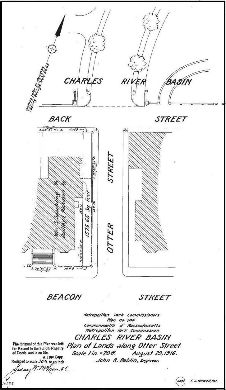
1916 plan of land taken by the Metropolitan District Commission to widen Otter Street; Suffolk Co. Deed Registry, Book 3988, p. 611 (27Sep1916).
The Boston and Roxbury Mill Corporation also laid out Otter Street, a 40 foot wide road running between Beacon and the Charles River, west of 99 Beacon and east of 100 Beacon. On July 7, 1857, it transferred the land to the City of Boston for a public street.
In 1916, the legislature (Chapter 245, Acts of 1916) authorized the Metropolitan District Commission to take land to widen Otter Street and provide an improved connection to the roadway running along the Embankment to the Longfellow Bridge. The Commission took a10 foot strip from the land at 100 Beacon, reducing the lot from 56 to 46 feet in width and eliminating most of the garden area. When the house at 100 Beacon was replaced in 1924 by an apartment building, the new building occupied the entire lot.
After it was widened, Otter Street was merged with the roadway running along the Embankment as Short Side Road. In December of 1920, Ednah Anne (Rich) Morse, the wife of Lewis Kennedy Morse, asked the Metropolitan District Commission to change the name of the street to Embarkment Road. The Morses lived at 20 Short Side Road and previously had lived at 279 Marlborough. The Commission approved the change of name on December 15, 1920.
In 1998, Embankment Road was named David G. Mugar Way in honor of Boston businessman David G. Mugar, in recognition of his sustained personal and financial support of Boston’s Fourth of July celebrations.
Building Restrictions in Original Land Deeds
All of the deeds from the Boston and Roxbury Mill Corporation included language limiting the use of buildings to dwelling houses and appurtenant structures (including stables); requiring that the main buildings (not the appurtenant structures) be built of brick, stone, or other noncombustible material; and specifying that the buildings be set back a specified distance from the street.
Unlike the deeds from the Commonwealth of Massachusetts, the Boston and Roxbury Mill Corporation deeds did not require that buildings be of a minimum number of stories in height. The Commonwealth deeds, however, did not require that buildings be built of brick, stone, or other noncombustible material.
Also unlike the Commonwealth deeds, the corporation’s deeds specified a date after which the building restrictions would no longer apply. The earliest deeds specified that the restrictions would remain in force until November 15, 1897. Deeds after May 24, 1855, set the expiration date as January 1, 1900, and deeds dated after March 15, 1886, set the expiration date as January 1, 1950.
The specifics of the corporation’s deed restrictions evolved over time. The first deeds, on January 1, 1855, specified that the land “shall be used for dwelling houses alone, and their appurtenances, including a barn on said thirty feet street [Back Street], and that all buildings erected thereon shall have exterior walls of stone, or brick, or other incombustible material, and shall be set back from the front line of the granted premises of said Road, and not project Southward of the line of the front wall of the house of William W. Goddard [at 99 Beacon] continued across the granted premises excepting however that bow or swell fronts, porticoes, balconies, steps, bay windows, eaves, or other projections similar to those enumerated, may extend three and one half feet nearer to said Mill Dam Road than said Goddard’s said line…” (Book 675, p. 134; 1Jan1855).
By June of 1855, the setback requirement was specified as nineteen feet from Beacon (rather than based on the depth of 99 Beacon). This setback was included in all of the deeds for land between Otter Street and Berkeley, and also for the first fifty feet west of Berkeley, where 132-134 Beacon were built. The deeds for the land further west, starting with the land at 136 Beacon (Book 755, p. 129; 31Mar1859) included a twenty foot setback.
By January of 1860, the description of buildings allowed in the rear of the property had been modified to specify “the usual outbuildings, including a stable” (instead of a barn).
Most of the deeds from the Boston and Roxbury Mill Corporation were silent on the height of buildings in the rear of properties. As a result, a number of property owners entered into agreements or added deed restrictions limiting the height and/or location of such structures in order to preserve their views from the upper windows of their homes. Reflecting this concern, the corporation’s deeds after July 31, 1890 – all for land located between Hereford and Massachusetts Avenue – included a provision, expiring on January 1, 1910, that limited any building built in the rear of the property to no more than one story in height.
All of the corporation’s deeds also included language specifying that “the center of the easterly and westerly partition walls of the houses and buildings first erected on the said land shall be placed on the division lines between the granted premises and the adjoining lots, and shall be good and sufficient walls, and the party first building such partition wall, whether the owner of the premises hereby granted or of an adjoining lot, shall be entitled to have and receive from the party using such wall, one half of the actual cost of so much of said wall, including the pile foundations, and stone or brick work, and fences as he shall actually use” (Book 780, p. 30; 8Jun1860). The deeds from the Commonwealth did not include language dealing with the placement of or payment for party walls and, as a result, individual land owners frequently entered into separate party wall agreements.
The Storrow Memorial Embankment on the Esplanade
The area north of Back Street has evolved significantly since the original sea wall was constructed by the Boston and Roxbury Mill Corporation. Today, it is part of what is popularly known as the Esplanade.
The Boston Landmarks Commission’s 2009 study report described the Esplanade as the “informal name for the state-owned parkland” comprising Charlesbank to the west, between Craigie Bridge and the Longfellow Bridge, the Storrow Memorial Embankment in the middle, between the Longfellow Bridge and the Harvard Bridge, and Charlesgate/Upper Park to the west, between Harvard Bridge and the Boston University Bridge.
The Embankment evolved significantly since the late 19th Century, including being the focus of a number of development and transportation proposals that were of significant interest and often deep concern to the residents of the north side of Beacon Street.
The development of the Embankment is documented in detail both in Gaining Ground by Nancy Seasholes and in Inventing the Charles River, by Karl Haglund.
Charles River Flats. The first proposal to fill the land north of Back Street was considered in 1869. By that point, much of the Commonwealth’s land in the Back Bay had been filled and the Boston and Roxbury Mill Company’s land on the north side of Beacon had been developed with houses as far west as Dartmouth.
During the 1869 legislative session, the Massachusetts House of Representatives, at the recommendation of its Committee on Harbors (House Doc 479, 1869), appointed a special committee to “prepare a comprehensive plan for the occupation and improvement of the flats and water areas of Mystic River, and of Miller’s and Charles Rivers, above Charles River Bridge, and of South Bay, Fort Point Channel, and Dorchester Bay.”
The Committee held hearings in November and December of 1869 on various alternative approaches to filling the lands north of Back Street. The concept was strongly opposed by the property owners who would be adversely affected, who argued that filling the flats for more housing would deny them the light, air, and view that made their property desirable. The concept also was opposed by the City of Boston, whose representatives expressed concerns that narrowing the river would disrupt the “scouring” action of the tides which carried the sewage discharged into the river out to sea, and also could impede the operations of the Boston harbor.
Among the witnesses at the hearing on November 8, 1869, was Dr. Oliver Wendell Holmes, physician, professor, and noted poet, essayist, dramatist, and novelist. He lived at 164 Charles Street (in 1870, he built a new home at 296 Beacon). He testified: “I am one of very many citizens of Boston who would be deeply afflicted and distressed in mind, body and estate, if this plan were carried out. In mind, as it threatens one of the principal comforts and enjoyments of our lives. In body, as it contemplates cutting us off from the great air reservoir to which, in the hotter months, we look as the safeguard of our health. In estate, because we have invested our property and our children’s inheritance on the faith of a line which we believed to come practically under the safeguard of that ancient commination: ” Cursed be he that removeth his neighbor’s landmark; and all the people shall say, Amen.”
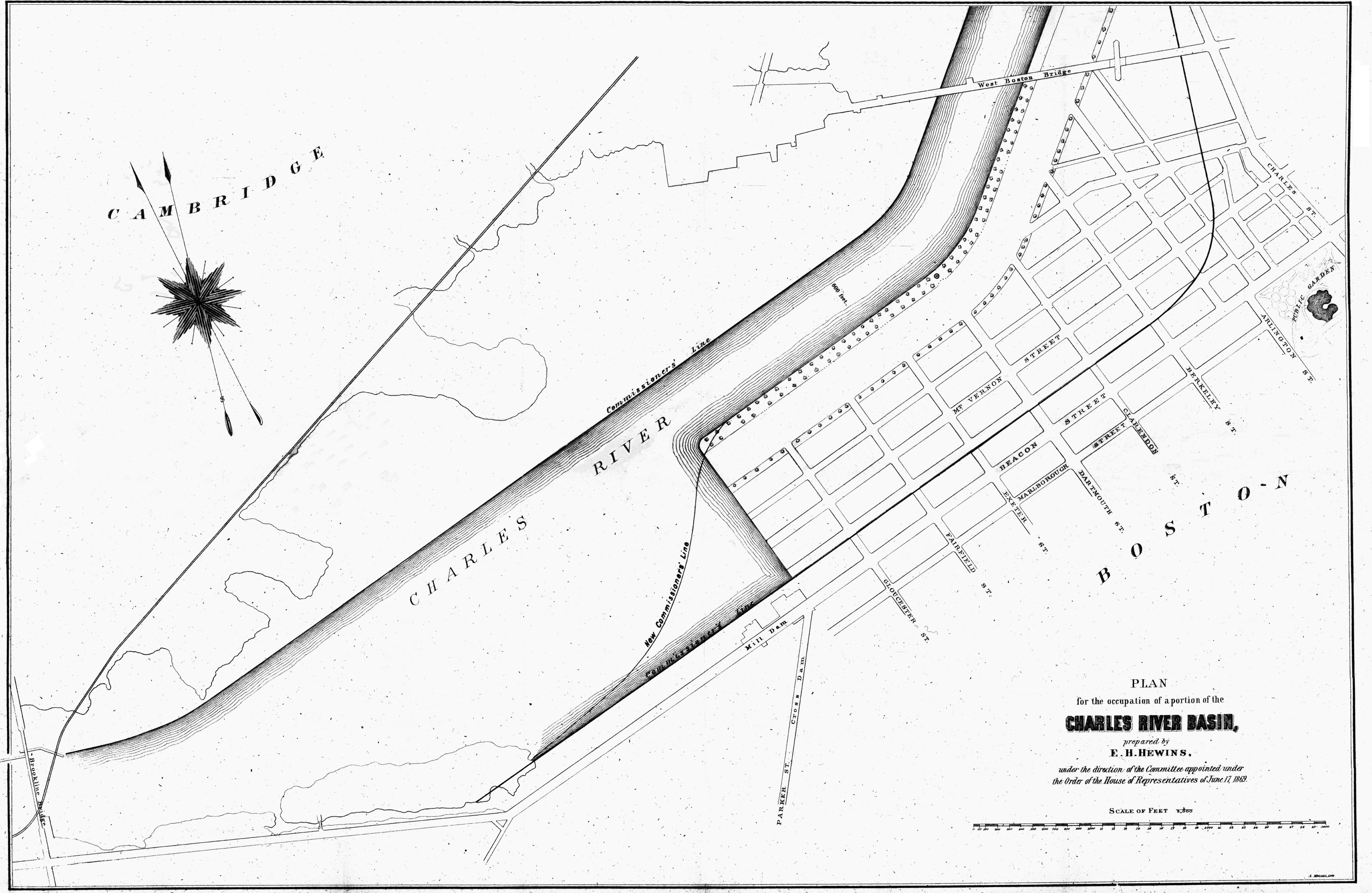
Proposed filling of the Charles River flats north of Beacon Street, Report to the Massachusetts House of Representatives Doc. 240, 1870; courtesy of the Massachusetts State Library, Special Collections
On March 29, 1870, the Committee filed its report with the Legislature (House Doc 240, 1870). It dismissed the concerns expressed at the hearings and concluded that more land was necessary to accommodate population growth and that, “happily for the future of Boston, the capabilities of extension [of the city] are still almost indefinite” because of the land available by filling the tidal flats that surrounded much of the city.
With respect to the Charles River, the Committee proposed filling an area of about 7.5 million square feet between the West Boston Bridge (later the Longfellow Bridge) at Cambridge Street to the east and Parker Street (about about 210 feet west of where Hereford Street later would be laid out) to the west. Mt. Vernon Street would be extended across the filled land, running parallel with Beacon, with houses on either side. The backs of the houses on the south side would abut Back Street, which would become an alley similar to those in the rest of the Back Bay. There also would be an alley behind the houses on the north side of Mt. Vernon, with another row of houses fronting on a new tree-lined esplanade overlooking the Charles River. The river would be significantly narrowed and would be dredged to a deeper level to provide for ship travel and the tidal flow of the river.
After deducting land used for the streets and esplanade, the proposal would have created about 3,678,000 square feet of land that could be sold for building purposes, and the Committee projected the sale of this land would result a net profit to the state of $3,115,000.
The Boston Evening Transcript’s April 5, 1870, report on the plan commented that “the Committee takes a very cheerful view of the future of Boston,” and the Boston Journal stated that “we are far from convinced by this report that the evidence of eminent physicians and the sanitary effects of living entirely upon made land are entirely fallacious.”
After the Committee filed its report, no further action appears to have been taken by the legislature. Soon after the report was issued, the demand for Back Bay land began to decline, reducing the incentive for the project. Real estate values remained depressed through much of 1870s both because of the Great Boston Fire in November of 1872 and the national financial Panic of 1872 and economic downturns that followed.
Back Bay Park. Although efforts to fill the Charles River flats to create additional building lots abated during the 1870s, efforts to create parklands along the Charles River did not. Throughout the 1870s, proposals to create embankment parks along the Charles River were pursued. These ultimately resulted in the approval of two major park areas: the Back Bay Park (later the Back Bay Fens) where the Muddy River joined the Charles River, and the Charlesbank Park between the West Boston Bridge at Cambridge Street and the Craigie Bridge at Leverett Street. The approval, funding, and construction of both parks was prolonged and often controversial, but both were completed by about 1890.
Although plans for an embankment park between the Charlesbank and the Back Bay Fens were proposed and received public support, no action was taken.
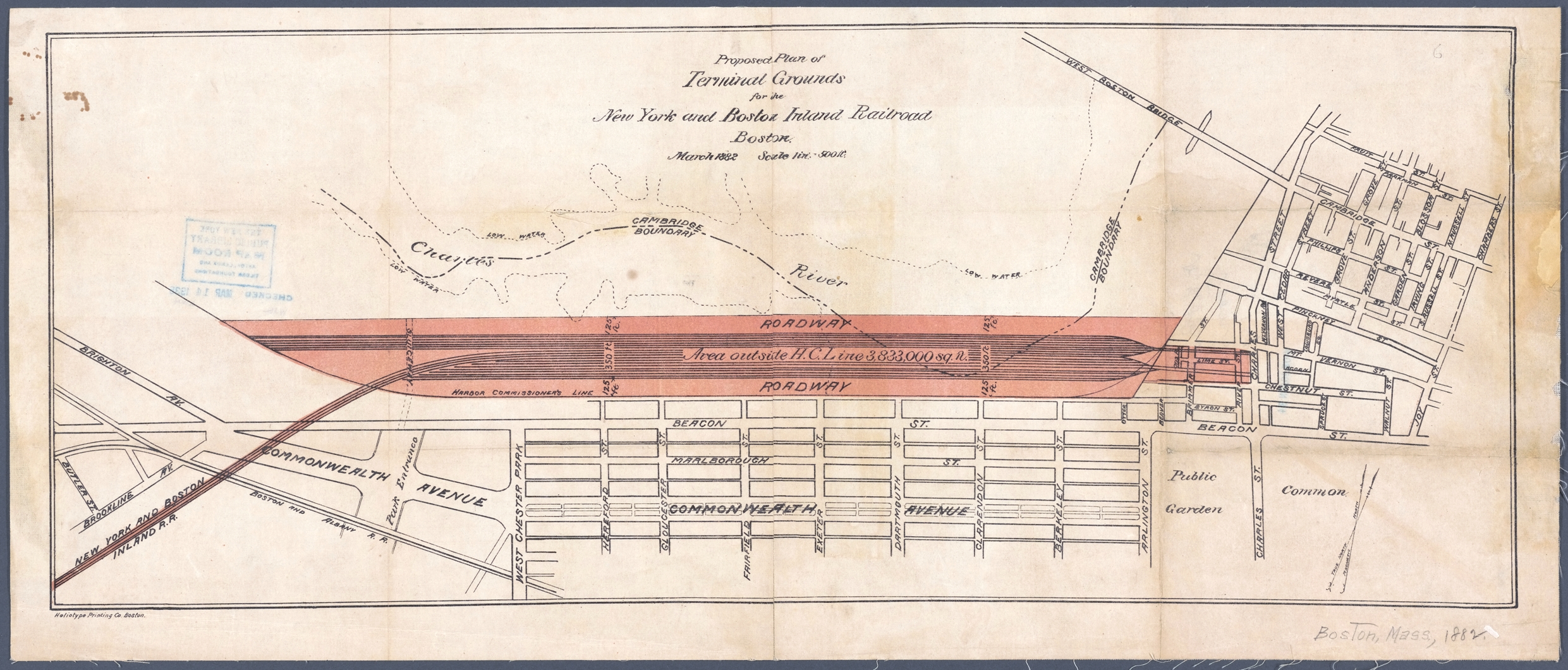
Proposed plan of the New York and Boston Inland Railroad (ca. 1882), courtesy of the New York Public Library
New York and Boston Inland Railroad. In 1881, the newly formed New York and Boston Railroad sought to build a new line connecting Boston and New York City. The proposal, which was promoted as significantly reducing the travel time between the two cities, would have started at a station on Charles Street between Chestnut and Mt. Vernon, then run over elevated tracks north of Back Street, then through Brookline into Connecticut, ending in Mt. Vernon, New York, north of the Bronx.
Back Bay and Brookline residents expressed strong opposition, expressing their concern that the proposed route, expressing their concern that the proposed route would diminish the value of their property. The railroad subsequently proposed an alternative that would have departed from the Boston and Providence Railroad station and avoided the Charles River. However, the line ultimately was not built.
Charles River Embankment. Proposals for creation of an embankment park between Charlesbank and the Back Bay Fens continued to receive public support. In its March 26, 1882, article on a meeting of Back Bay residents to oppose the railroad proposal, the Boston Globe cited comments by Nathan Matthews that “the value of the property on the Back Bay was steadily increasing and if the park which is now being talked of be laid out, it would become the most valuable portion of the city of Boston.”
In 1893 (Chapter 435, Acts of 1893), the legislature took steps to make the new park a reality. It authorized the City of Boston to construct a new sea wall 100 feet north of the existing one and to fill the land between the existing and new sea wall, with the proviso that the land “not be used for building purposes, or for any other purpose than for ornamental grounds and a parkway.”
The north side of Beacon as it appeared before the addition of the Embankment; detail from 1898 Bromley index map
Riverside Boulevard. Also in 1893 (Chapter 475, Acts pf 1893), the legislature directed the Metropolitan Park Commission and the State Board of Health to “investigate the sanitary condition and prepare plans for the improvement of the beds, shores and waters of the Charles River…and for the removal of any nuisances therefrom.”
In April of 1894, the two agencies issued a joint report recommending a number of major projects, most notably the construction of a dam to convert the lower Charles River from a tidal estuary into a fresh water basin.
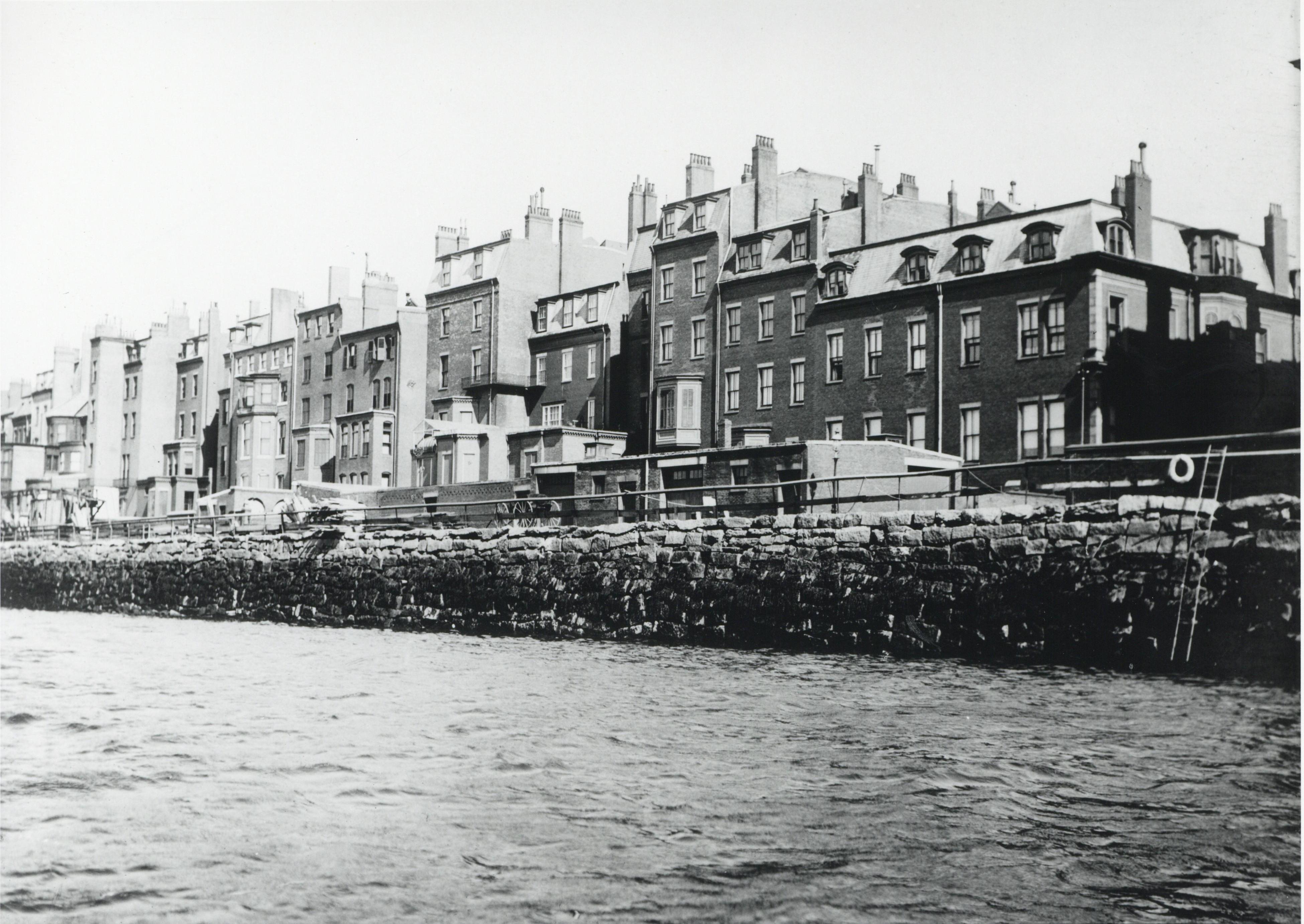
View of Back Street between Berkeley and Clarendon, showing original sea wall (24Jun1904), courtesy of the Boston City Archives
The report also proposed a number of other actions designed to address pollution and unsightliness, including the appearance of the rear yards of the houses on the north side of Beacon, “where some of the finest residences of the Back Bay district of the city of Boston are to be found” but where, the report concluded,“a poorly kept alley-way behind a line of unsightly sheds and stables,” together with an unsightly stone sea wall, detracted from the potential beauty and economic potential of the river.
To address this unsightliness, the report recommended that the embankment approved in 1893 (but not yet built) be expanded from 100 to 300 feet in width, with the 120 feet north of Back Street to be used for house lots and associated streets. Houses facing north would be built on this land and Back Street would become an alley similar to others in the Back Bay. The remaining 180 feet further north would be used for a parkway in front of the new houses and ornamental grounds. The report noted that the sale of the lots would “yield a large sum of money to be devoted to the repayment of the expenses of improvements herein recommended.”
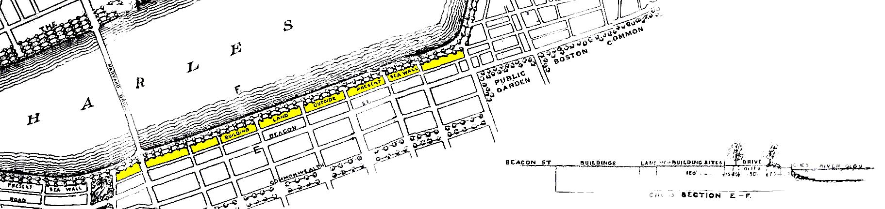
Detail from plan, colored to show proposed new building lots, from the Report of the Joint Board upon the Improvement of Charles River (April 1894)
The reaction of the homeowners on the north side of Beacon to what some newspaper reports called the “Riverside Boulevard” was swift and strong. The same arguments raised in 1869 were repeated once again, with residents expressing concern about the loss of their water view and the possible elimination of stable buildings behind their houses. As before, concerns also were expressed that damming the Charles River – into which sewage continued to be discharged – would disrupt the “scouring” action of the tides and create a stagnant bay similar to that which existed prior to the filling of the Back Bay.
The proposal – including the Charles River dam – was not approved by the Harbor and Land Commission.
Esplanade and Riverbank Subway. In the late 1890s, a more limited proposal to construct an embankment 40 feet (rather than 100 feet) wide for an esplanade that would run north of Back Street, received the support of the Harbor and Land Commissioners and many of the Beacon Street homeowners.
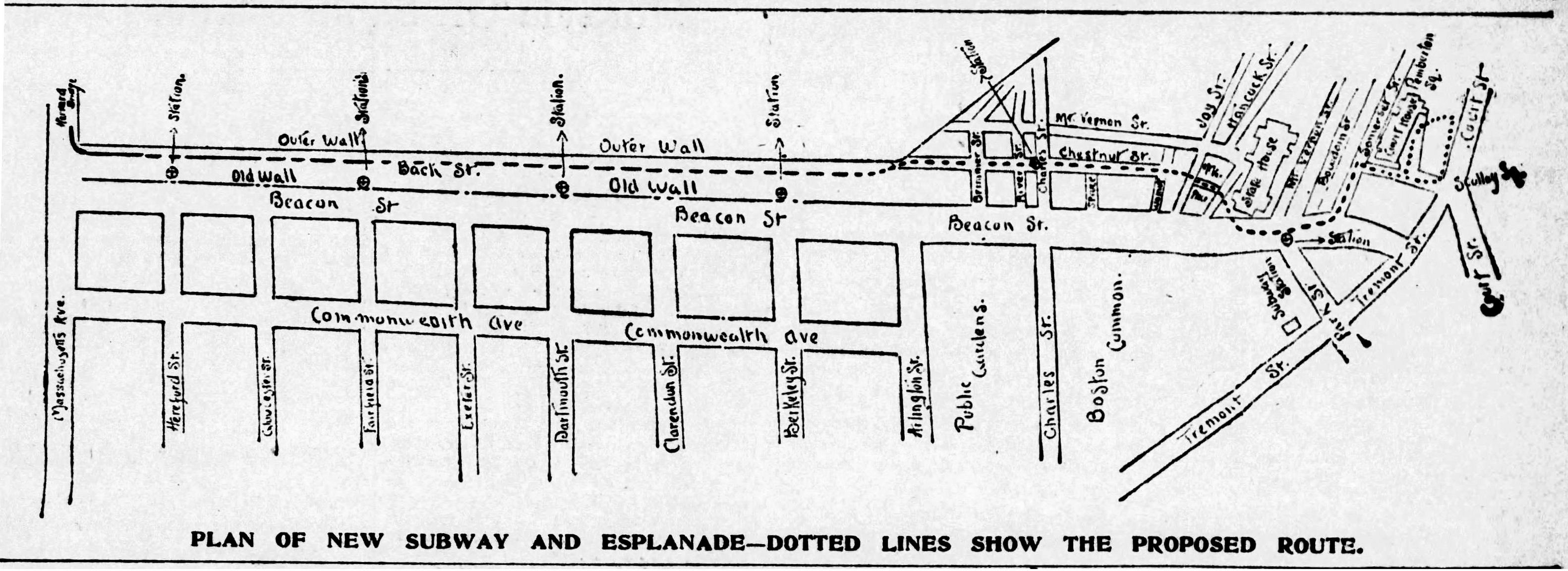
Plan of Mayor Josiah Quincy’s proposed embankment and subway; Boston Globe, 3Mar1899
When the legislature was about to take up the issue, however, Boston Mayor Josiah Quincy proposed an alternative plan to expand the proposed embankment from 40 to 75 feet, with the additional width used for streetcar tracks that would run from Massachusetts Avenue to Otter Street (now David G Mugar Way) on the surface and then into a subway tunnel under Beacon Hill. The Beacon Street homeowners strongly objected to the proposal and, in March of 1899, the Mayor proposed an alternative, keeping the width of the embankment at 40 feet and running tracks underneath it in a subway tunnel that would run from Scollay Square (now Government Center) through Park Street station, and continue under Beacon Hill and the embankment to Massachusetts Avenue. Concerns about this proposal were raised by the Boston Elevated Railway Company, which operated the streetcar system and commented (according to a March 4, 1899, Boston Globe article) that the proposal involved “problems of railroading, engineering and finance, and will bear investigation and further study” before the company could take a position on it.
Ultimately, no action was taken on either the embankment, with or without the subway.
Charles River Dam and Embankment. In the early 1900s the concept of constructing a Charles River dam and creating a fresh water Charles River Basin was revived.
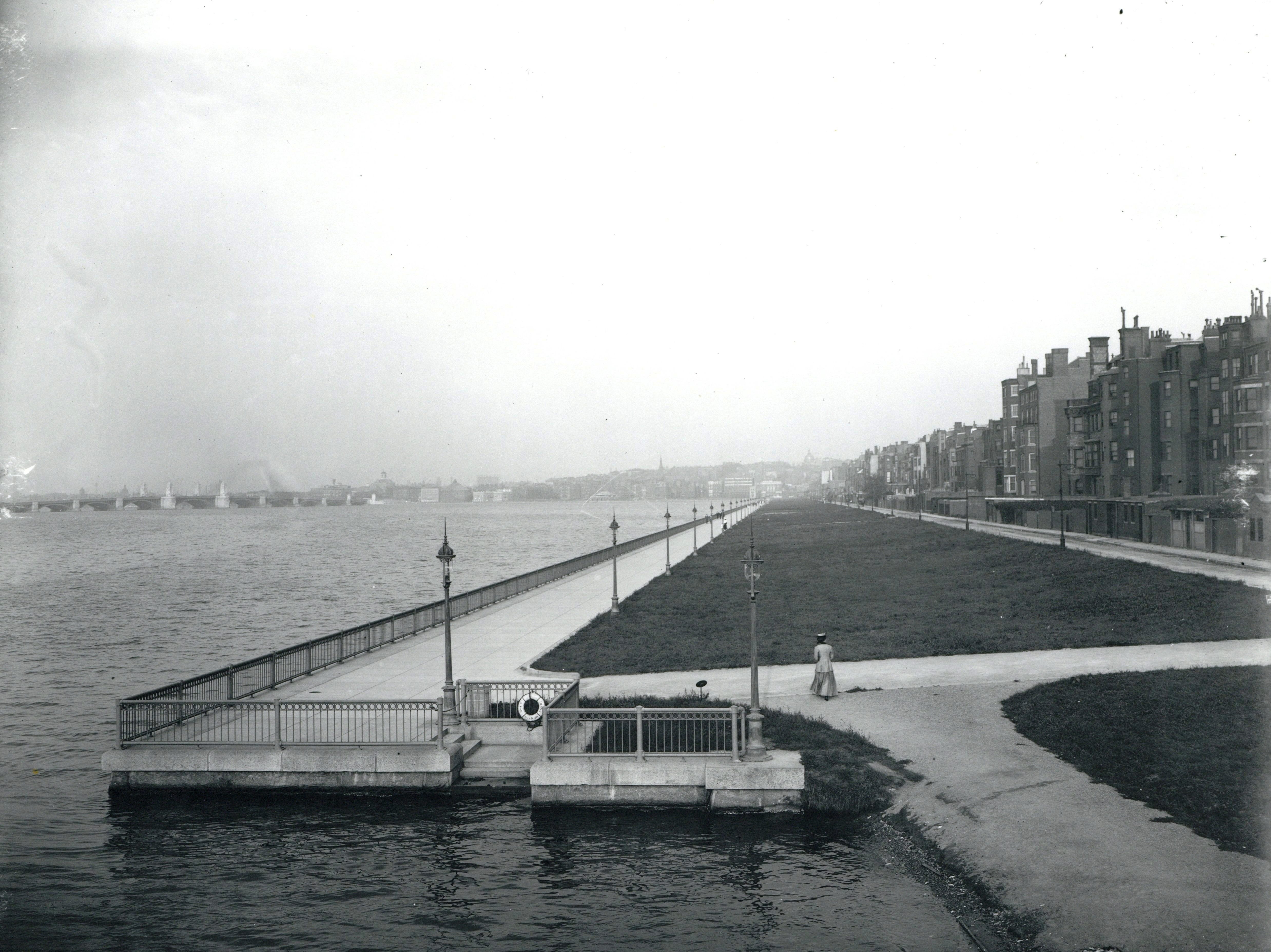
Charles River Embankment looking east from the Harvard Bridge (5Oct1910), courtesy of the Boston City Archives
The new proposal included the original 100 foot wide embankment for a park, rather than the 300 foot wide proposal that would have included construction of additional houses on the north side of Back Street Street or the 40 foot wide proposal considered in the late 1890s. It also included creation of the Boston Marginal Conduit, running below the new embankment to carry the overflow from the sewers and discharge it beyond the dam rather than into the new fresh water basin.
The proposal was approved by the legislature in 1903 (Chapter 465, Statutes of 1903). On October 6, 1906, the Charles River Basin Commission, created by the legislation, took possession of the land for the embankment, including the sea wall, for the City of Boston.
The new sea wall and Charles River Embankment, with a promenade running its full length and the Marginal Conduit below, were completed by 1908 and the Charles River dam was completed in 1910.
The north side of Beacon as it appeared after completion of the Charles River Embankment; detail from 1912 Bromley index map
Riverbank Subway. In 1907, as the embankment was under development, the concept of a subway tunnel was once again proposed. Similar to Mayor Quincy’s proposal in 1899, the new line was to run from Park Street station through a tunnel under Beacon Hill and the embankment, with the trains returning to the surface at Charlesgate West. The tunnel was to be built by the state and leased to the Boston Elevated Railway.
Detail from 1910 Boston Transit Commission map; courtesy of the Norman B. Leventhal Map Center at the Boston Public Library
The proposal once again met with strong resistance from residents, who expressed concern about the prolonged disruption from construction and the impact on property values in the Charlesgate West area. Concerns also were raised by the City of Boston that the location of the tunnel would require that sewage would be siphoned below the tunnel, creating both initial and on-going expense for the city.
After lengthy public debate, the Riverbank Subway proposal was abandoned in favor of constructing the Boylston Street subway through Copley Square.
Storrow Memorial Embankment. While the Charles River Embankment was aesthetically successful, it did not provide the recreational amenities many sought, and various plans were proposed to further expand and improve the park. In response, in 1928 the state legislature established a Special Commission on the Charles River Basin to “investigate the means and methods of making the Charles River Basin more safe, suitable, and attractive for recreation and civic welfare purposes.”
The Commission issued its report in early 1929. It proposed widening both the Embankment and the Charlesbank park, and also extending the park from Charlesgate West to the Cottage Farm Bridge (later renamed the Boston University Bridge), increasing the entire area of the Esplanade from 25 to 45 acres. The plan included recreational facilities, lagoons, and extensive new plantings. Helen Nell (Osborne) Storrow, the widow of James Jackson Storrow, pledged a donation of $1 million to finance many of the improvements in memory of her husband, who had died in March of 1926 (he had been an early advocate of the Charles River dam and the original embankment proposal; the Storrows lived at 417 Beacon).
The Commission’s report also proposed that a highway be constructed from the Longfellow Bridge to the Cottage Farm Bridge. This part of the proposal was strongly opposed by the residents of Beacon Street, who formed the Charles River Basin Association in January of 1929 to oppose the proposal. A January 22, 1929, Boston Globe article reported that the group supported many of the improvements proposed by the Commission but believed the proposed road would, according to its official statement, cause “’immeasurable harm’” and would “’undoubtedly become a speedway and would form a most dangerous barrier which persons would have to cross before reaching the river front.’” Mrs. Storrow indicated her support of the new organization and opposition to the roadway.
The proposed road was eliminated and the legislature empowered the Metropolitan District Commission to develop and implement a plan for the improvements (Chapter 371, Acts of 1929).
The final plan was completed in 1931, including adding about 150 feet of additional land north of the 1908 sea wall, sloping down to the water’s edge rather than ending in a new sea wall. The expanded park was completed in 1935 and named the Storrow Memorial Embankment.
The north side of Beacon as it appeared after completion of the Storrow Memorial Embankment, detail from 1938 Bromley index map
Storrow Drive. In the mid-1940s, a new plan for a road along the Embankment was proposed to address both the increasingly heavy traffic being experienced on Beacon and Commonwealth and to provide better vehicle access to Boston from the Western suburbs. The proposed road was included in the Commonwealth’s 1948 Master Highway Plan, and in 1949 legislation was introduced to construct the highway.
The proposal once again met with strong opposition from Back Bay residents, and state Representative James Cushing Bayley sought, unsuccessfully, to make any legislation approving the new highway subject to a referendum by Boston voters. Helen Storrow had died in November of 1944, and an April 29, 1949, Boston Globe article quoted Representative Gordon D. Boynton as commenting that “’Mr. and Mrs. Storrow would turn over in their graves if they knew their gift to the people was being turned into a high-speed highway, where children will be killed.”
The legislature, however, enacted the law (Chapter 262, Acts of 1949), authorizing the Metropolitan District Commissionto “lay out and construct a limited access” highway along the Charles River from Nashua Street near Leverett Circle to a point on Soldiers Field Road near the Boston University Bridge. The legislation included provisions that “where the construction authorized by this act results in reduction of areas now used for recreational purposes, additional land of substantially equivalent area shall be made by filling in the river.” As Nancy Seascholes notes in Gaining Ground, “as a final irony” the legislation also provided that the portion of the road between Embankment Road and Soldiers Field Road was to be named the James J. Storrow Memorial Drive.
The new highway was completed in 1951.
The north side of Beacon as it appeared after completion of Storrow Drive; detail from 2000 AAA map
