The block on the north side of Commonwealth between Arlington and Berkeley is 596 feet in length and 124 feet 6 inches from Commonwealth to Alley 422.
The land was part of the approximately 108 acres of land in the Back Bay owned by the Commonwealth of Massachusetts.
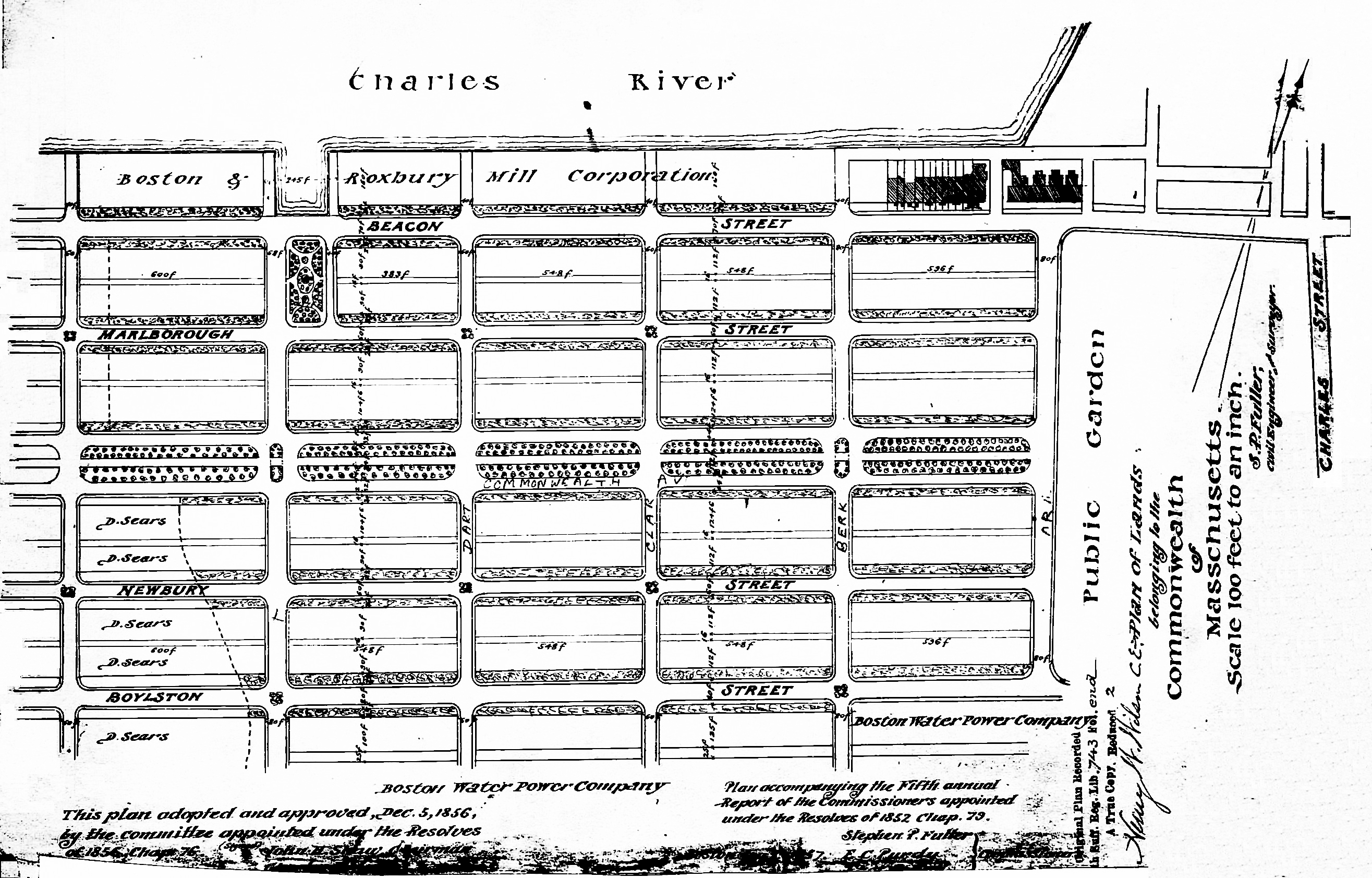
Plan of Commonwealth lands, 5Dec1856 (Suffolk Co. Deed Registry, Book 743, end of book)
The Commonwealth sold its land starting in 1857. The earliest transactions were by private sales negotiated by the Commissioners on the Back Bay. In 1860, the legislature required that all future sales be made through public auctions. The first auction was held on October 24, 1860, and they continued until March of 1872, when they were suspended due to depressed real estate values. In 1879, the legislature authorized the Harbor and Land Commissioners (successors to the Commissioners on the Back Bay) to sell lots with frontages of up to 100 feet by privately negotiated sale. The land sales resumed in May of 1879 and the last of the remaining land was sold in 1886.
Click here for more information on the Commonwealth of Massachusetts land in the Back Bay.
The Commonwealth sold its land on the north side of Commonwealth between Arlington and Berkeley in 1858 and 1860.
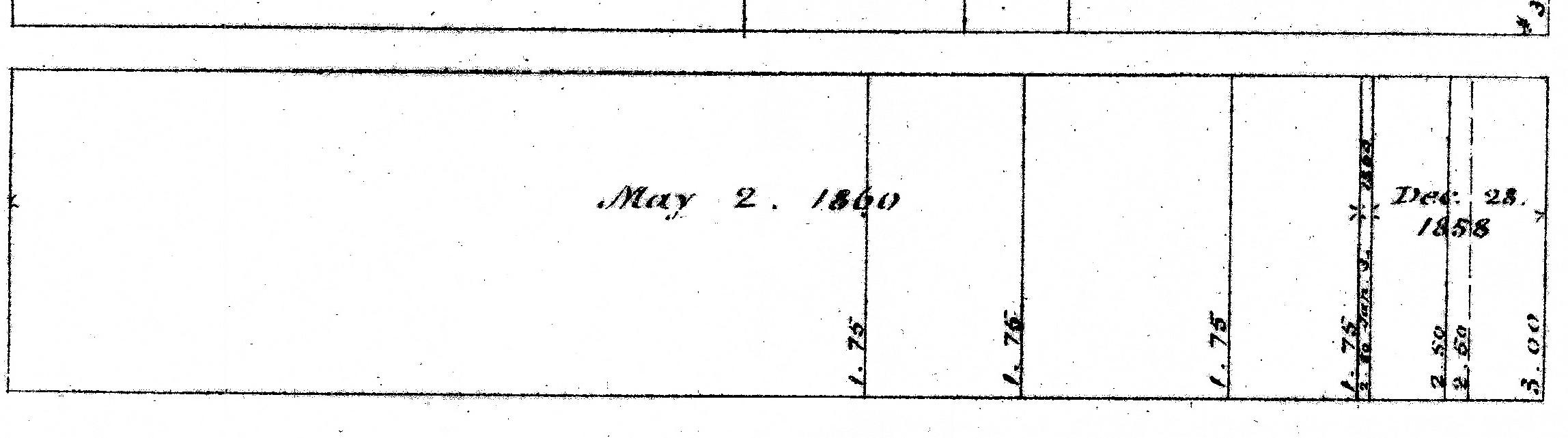
Excerpt from plan of land sales through 1879, showing price paid per s.f.; 1879 Harbor and Land Commissioners Report
Eastern Parcels. The Commonwealth sold the land at the east end of the block on December 28, 1858.
John Douglas Bates, shipping merchant in the sugar trade, purchased a 38 foot wide lot at the northwest corner of Commonwealth and Arlington, and Samuel Gray Ward, a merchant and banker, purchased a 30 foot lot immediately to the west. On July 12, 1859, Samuel Ward sold John Bates a strip of land 3.5 wide, increasing John Bates’s lot to 41.5 feet in width; John Bates and his wife, Mary (Bordman) Bates, built their home at 12 Arlington soon thereafter.
On January 3, 1860, Samuel Ward purchased a 3.5 foot wide strip of land from the Commonwealth to the west of his current land, thereby restoring his lot to 30 feet in width, where he and his wife, Anna Hazard (Barker) Ward, built their home at 1 Commonwealth.
Central and Western Parcels. The Commonwealth sold the remainder of its land on the block on May 2, 1860. The land was acquired by four purchasers: Benjamin S. Rotch, Abbott Lawrence, Samuel Ward, and Samuel Hooper.
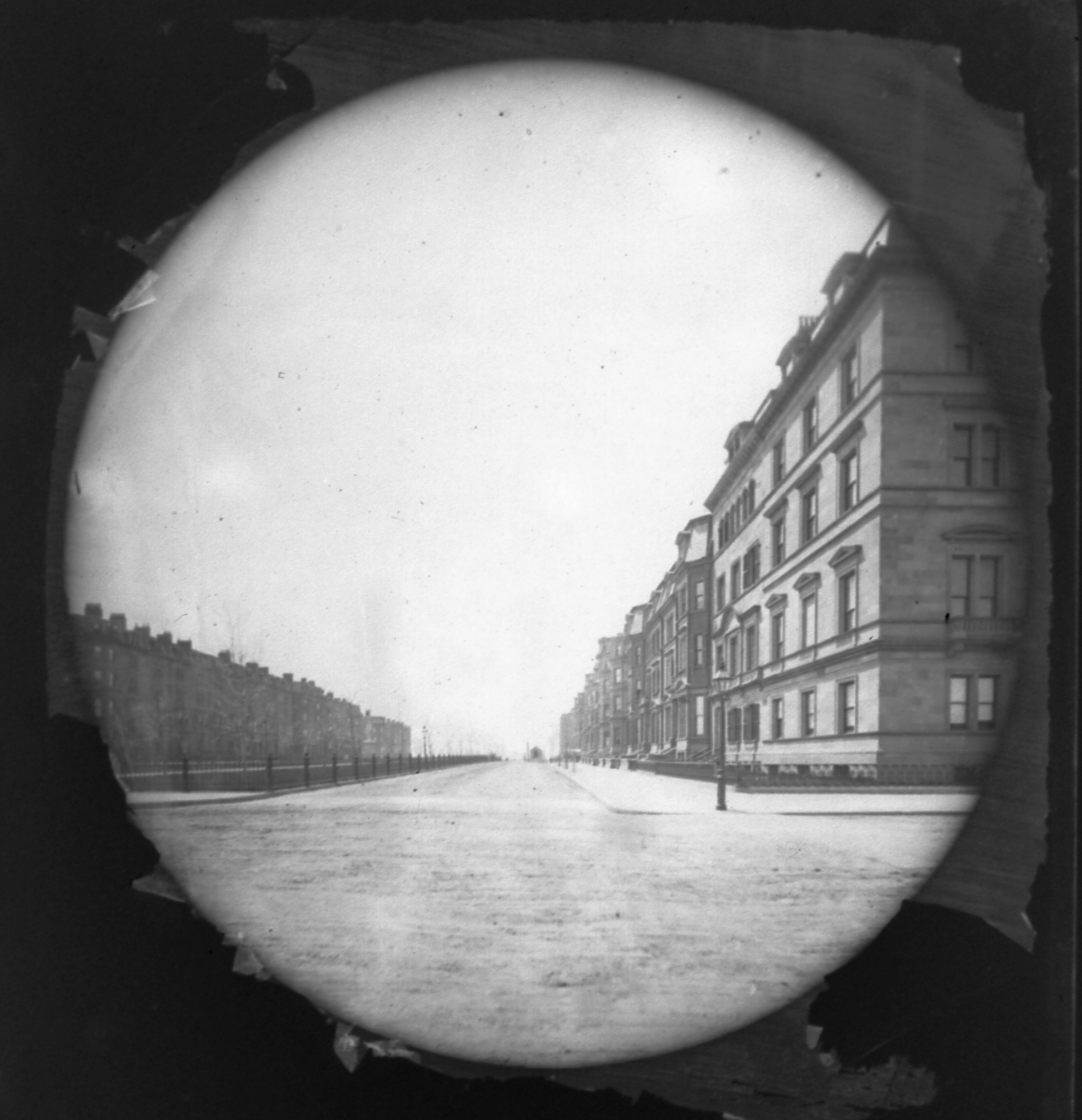
Looking west on Commonwealth, with 12 Arlington in the foreground (ca. 1867), Josiah Johnson Hawes Collection (#426), courtesy of The John F. Kennedy Library Foundation, Boston (licensed by The John F. Kennedy Library Foundation. all rights reserved).
On March 26, 1860, the Boston Evening Transcript commented on their impending purchase, referencing an earlier article that appeared in the Boston Gazette:
“The Back Bay, The Gazette says that several gentlemen, including Abbott Lawrence, Mr.Rotch, Mr. Davis and Mr. Hooper, and others, have recently purchased large lots of land on Commonwealth avenue, with the intention of building private residences. We learn that this purchase is only contemplated, and that many preliminaries remain to be settled before it is consummated. The proposition contemplates the buying of all the land on Commonwealth avenue, between Arlington and Berkley [sic] streets, and the erection of splendid dwellings, which will add greatly to the appearance of that section of the city.”
Benjamin Smith Rotch, a merchant and founder of the New Bedford Cordage Company, purchased the parcel furthest east, abutting Samuel Ward’s land, with a frontage of 50 feet, and he and his wife, Annie Bigelow (Lawrence) Rotch, built their home at 3 Commonwealth. His brother-in-law, Abbott Lawrence, cotton manufacturer and merchant, purchased the lot to the west, with a frontage of 80 feet, and he and his wife, Harriette (Paige) Lawrence, built their home at 5 Commonwealth.
The 60 foot lot to the west of Abbott Lawrence’s lot was purchased by Samuel Ward of 1 Commonwealth, who then sold a 30 foot lot at 7 Commonwealth to Samuel Johnson, Jr., and a 30 foot lot at 9 Commonwealth to Richard C. Greenleaf, both of whom built their homes on the lots. Samuel Johnson and Richard Greenleaf were partners in the wholesale dry goods firm of C. F. Hovey & Co.
The remainder of the block, with a 334.5 foot frontage, was purchased on May 2, 1860, by shipping merchant and US Congressman Samuel Hooper. On the same day, he also purchased a 78 foot parcel and a 220 foot parcel on the south side of Commonwealth and in June of 1860 acquired the 60 foot parcel between them, the combined 358 foot parcel comprising the lots where 20-48 Commonwealth would be built.
Samuel Hooper built his home at the northeast corner of Commonwealth and Berkeley, at 25-27 Commonwealth. He and his wife, Anne (Sturgis) Hooper, lived at 27 Commonwealth and their son and daughter-in-law, William Sturgis Hooper and Alice (Mason) Hooper, lived at 25 Commonwealth.
On July 2, 1860, he sold the remainder of his land on the north side of Commonwealth to four purchasers: a 50 foot lot at 11-13 Commonwealth to Frederick H. Bradlee; a 50 foot lot at 15 Commonwealth to James Davis, Jr., a 50 foot lot at 17-19 Commonwealth to John P. Bayley, and a 60 foot lot at 21-23 Commonwealth to Gardiner Howland Shaw.
Frederick H. Bradlee had 13 Commonwealth built as his home and 11 Commonwealth built as the home of his son-in-law and daughter, Henry Ward Abbot and Elizabeth Gair (Bradlee) Abbot.
James Davis, Jr., who purchased the lot at 15 Commonwealth (and who was mentioned in the March 26, 1860, Boston Evening Transcript article) sold the lot on November 1, 1862, to banker and broker Robert Marion Pratt. He, in turn, sold the lot on February 2, 1863, to Richard Codman, who sold it one week later, on February 10, 1863, to William Dudley Pickman of Salem. William Pickman built his home at 15 Commonwealth.
John Prince Bayley, a commission merchant, sold the lot at 17-19 Commonwealth on April 10, 1861, to Henry Sigourney, Jr., who sold it on October 19, 1861, to Thomas Forbes Cushing. He and his wife, Fanny Leslie (Grinnell) Cushing, lived at 190 Beacon. On September 11, 1866, he sold the land to his uncle, attorney William Howard Gardiner, who built his home on the eastern 30 feet at 17 Commonwealth. He sold the western 20 feet on March 7, 1867, to attorney Thomas Coffin Amory and his sisters, Rebecca A. Amory and Isabella L. Amory, who built their home at 19 Commonwealth.
Gardiner Howland Shaw sold the 60 foot lot at 21-23 Commonwealth on July 10, 1865, to attorney John Chipman Gray. He and his wife, Elizabeth Pickering (Gardner) Gray, lived at 30 Summer. On January 29, 1867, John Gray sold the western 20 feet frontage to Daniel Spooner on January 29, 1867, at which time he indicated that had contracted to sell the land the east to Joseph B. Moors. That sale apparently did not close and on March 29, 1867, John Gray sold the eastern portion, with a 29.5 foot frontage, to John Burnham, and the strip in the middle, with a 10.5 foot frontage, to Daniel Spooner, bringing that lot to 30.5 feet. John Burnham built his home at 21 Commonwealth and Daniel Spooner built his home at 23 Commonwealth.
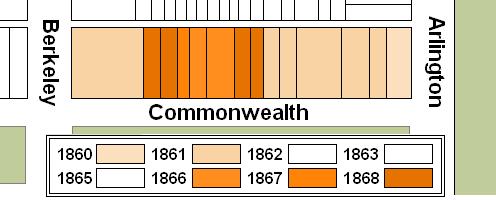
Original Construction. All of the houses on the north side of Commonwealth between Arlington and Berkeley had been built by 1868.
The plans below illustrate when the land on the block was first purchased from the Commonwealth (based on the dates of the deeds) and when houses were first constructed (based on news reports and on dates provided in Bainbridge Bunting’s Houses of Boston’s Back Bay).
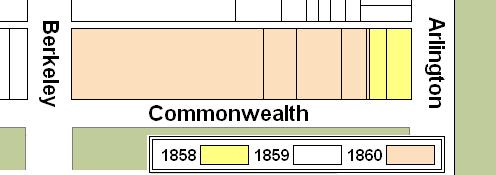
Original land purchases on the north side of Commonwealth between Arlington and Berkeley
Building Restrictions in Original Land Deeds
The deeds from the Commonwealth for land at 12 Arlington and 1 Commonwealth (Suffolk Co. Deed Registry Book 749, p. 244; Book 750, p. 39; and Book 778, p. 67) specified that any building on the land was to be “at least three stories high for the main part thereof and shall not in any event be used for a stable, or for any mechanical, mercantile or manufacturing purposes;” that the front walls were to be set back twenty feet from Commonwealth, with “steps, windows, porticos, and other usual projections appurtenant thereto” allowed in the reserved space; and that “no cellar or lower floor of any building shall be placed more than four feet below the level of the mill-dam, as fixed by the top surface of the hammered stone at the south-easterly corner of the emptying sluices.” The deeds also provided that the owners of the land would have the right to “cultivate trees on the side walks” in front of their land provided that they left a distance of ten feet between the front boundary of their lots and the trees.
The language of May 2, 1860, deeds to Samuel Ward (for land at 7-9 Commonwealth; Suffolk Co. Deed Registry Book 778, p. 4), Abbott Lawrence (for land at 5 Commonwealth; Book 2155, p. 36, recorded 27Sep1893), and Samuel Hooper (for land at 11-27 Commonwealth; Book 780, p. 180) varied slightly from these other deeds. These deeds specified in that the height of the buildings was required to be “at least three stories high for the main part thereof (or two stories with a Mansard Roof).” The addition of the language about mansard roofs did not appear in most other earlier or later deeds from the Commonwealth. It was, however, also included in the Commonwealth’s deeds to Samuel Hooper for land on the south side of Commonwealth between Arlington and Berkeley. Samuel Hooper’s home at 27 Commonwealth was two stories with a mansard roof, and he may have requested that the language be included in the deeds.
The deeds to Samuel Hooper, Samuel Ward, and Abbott Lawrence (and in the deeds to Samuel Hooper for land on the south side of Commonwealth) also include language clarifying that the prohibition against stables did not include private stables. This language reflected a November 1858 decision by the Commissioners on the Back Bay that the prohibition on stables would not be enforced “in such a manner as to prevent the erection and use of private stables by gentlemen as appurtenances to their own dwelling homes; provided, such stables are so constructed and used as not to be justly offensive to the occupants of the surrounding buildings.” This clarification was subsequently published in the auction catalogues issued by the Commissioners, but usually was not included in the deeds.
Samuel Hooper built a large stable at 27 Commonwealth and, again, the inclusion of the language in the deeds may have reflected his wish to make the Commissioners’ policy explicit in the deed.
The twenty foot setback requirement was identical in all of the deeds. In January of 1863, the Commissioners on Public Lands (successors to the Commissioners on the Back Bay) adopted dimensional limitations on the projections allowed in the setback area. These applied to the deeds previously executed by the Commonwealth, including the land on the north side of Commonwealth between Arlington and Berkeley.
Click here for more information on the restrictions contained in deeds of Back Bay land.
Original Land Deeds
The Commonwealth of Massachusetts conveyed the land on the north side of Commonwealth between Arlington and Berkeley by the following deeds:
| Address | Date | E-W | N-S | Grantee | Book | Page |
| 12 Arlington | 28Dec1858 | 38’ | 124.5’ | John D. Bates | 749 | 244 |
| 1 Commonwealth | 28Dec1858 | 30’ | 124.5’ | Samuel G. Ward | 750 | 39 |
| 1 Commonwealth | 03Jan1860 | 3.5’ | 124.5’ | Samuel G. Ward | 778 | 67 |
| 3 Commonwealth | 02May1860 | 50’ | 124.5’ | Benjamin S. Rotch | 777 | 230 |
| 5 Commonwealth | 02May1860 (recorded 27Sep1893) | 80’ | 124.5’ | Abbott Lawrence | 2155 | 36 |
| 7-9 Commonwealth | 02May1860 | 60’ | 124.5’ | Samuel G, Ward | 778 | 4 |
| 11-27 Commonwealth | 02May1860 | 334.5′ | 124.5’ | Samuel Hooper | 780 | 180 |
