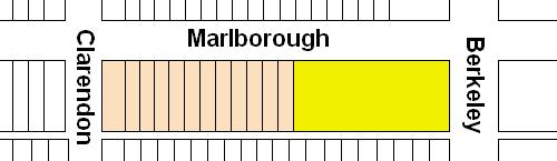
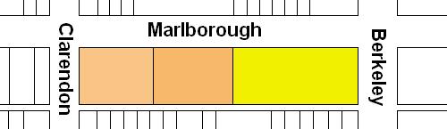
The block on the south side of Marlborough between Berkeley and Clarendon is 548 feet in length and 112 feet from Beacon to Alley 423.
The land was part of the approximately 108 acres of land in the Back Bay owned by the Commonwealth of Massachusetts.
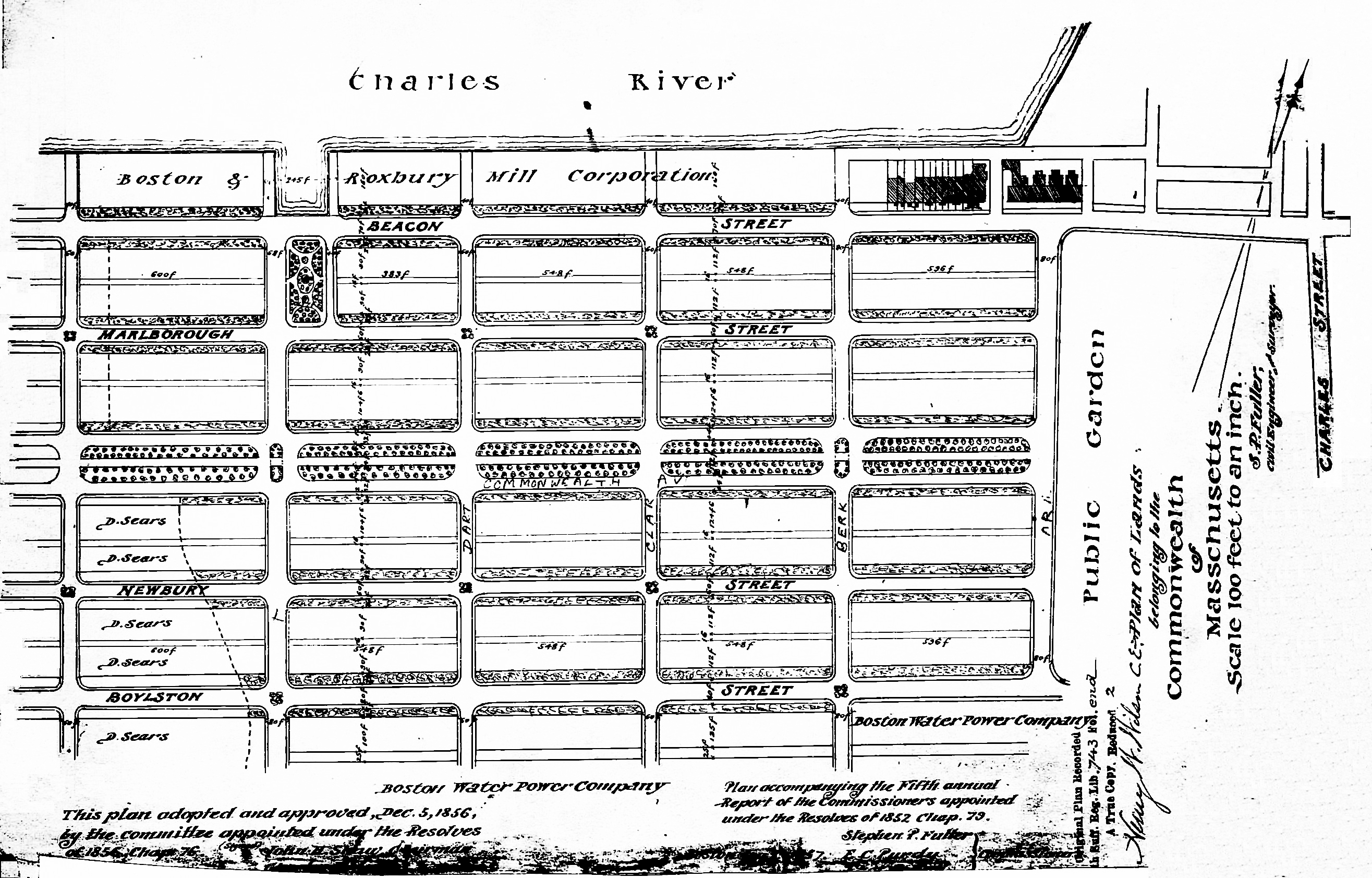
Plan of Commonwealth lands, 5Dec1856 (Suffolk Co. Deed Registry, Book 743, end of book)
The Commonwealth sold its land starting in 1857. The earliest transactions were by private sales negotiated by the Commissioners on the Back Bay. In 1860, the legislature required that all future sales be made through public auctions. The first auction was held on October 24, 1860, and they continued until March of 1872, when they were suspended due to depressed real estate values. In 1879, the legislature authorized the Harbor and Land Commissioners (successors to the Commissioners on the Back Bay) to sell lots with frontages of up to 100 feet by privately negotiated sale. The land sales resumed in May of 1879 and the last of the remaining land was sold in 1886.
Click here for more information on the Commonwealth of Massachusetts land in the Back Bay.
The eastern 250 feet of land on the south side of Marlborough between Berkeley and Clarendon was transferred by the Commonwealth to the City of Boston on July 7, 1859, as partial settlement of the City’s dispute with the Commonwealth over rights to lands in the Back Bay. The remainder of the land on the block was sold by the Commonwealth at its auction on October 24, 1860.
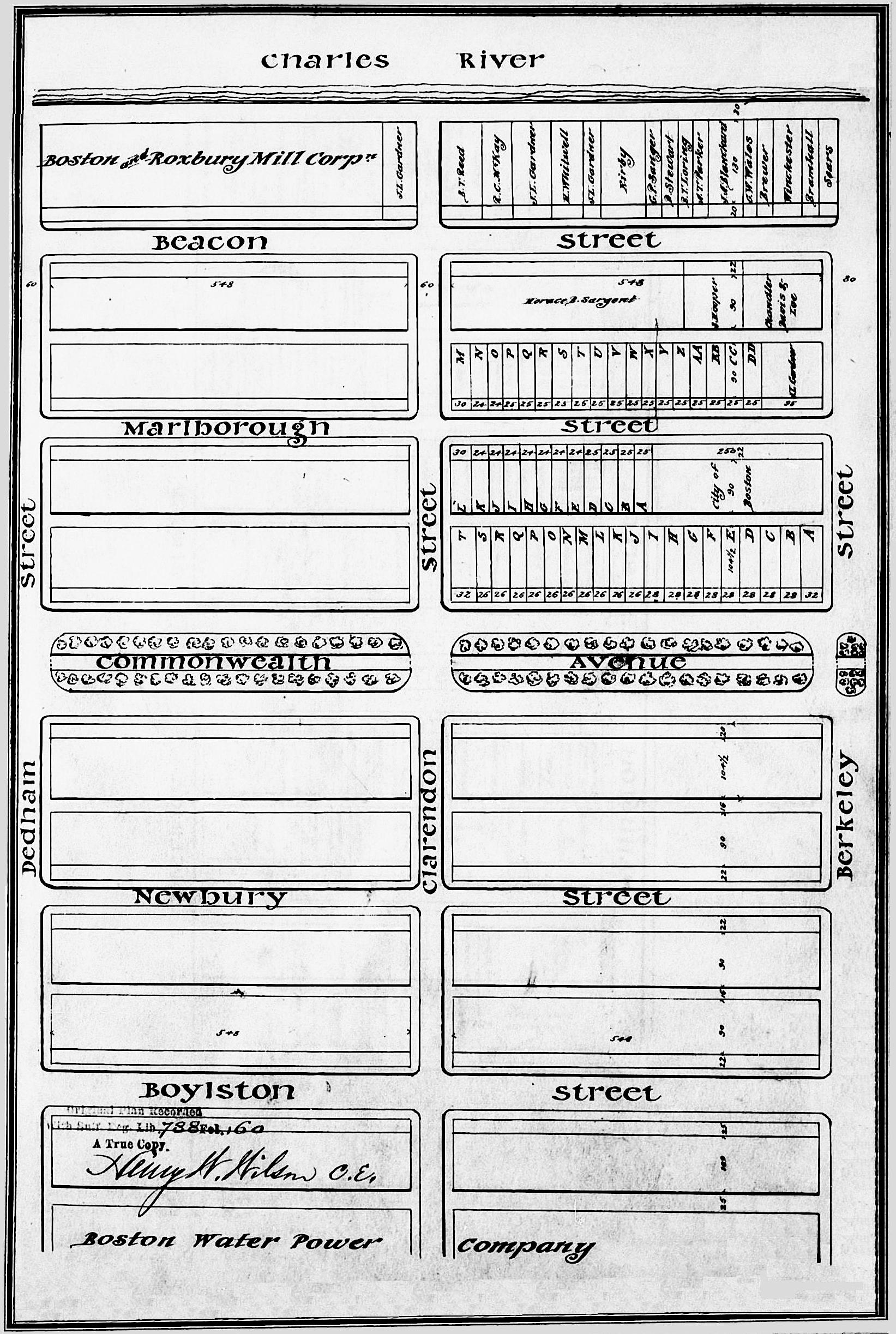
Excerpt from plan of land sales through 1879, showing price paid per s.f.; 1879 Harbor and Land Commissioners Report
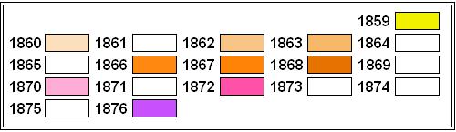
Eastern Parcel. On September 15, 1865, the First Church in Boston entered into an agreement with the City of Boston to purchase the land at the corner of Marlborough and Berkeley, with a frontage of 175 feet on Marlborough. The church was constructed in 1867-1868. Under its agreement with the City, the Church paid $3 per square foot, payable ten percent in cash and balance in nine installments at six percent interest. The final payment was made in 1876 and the City transferred the land to the Church on April 20, 1876.
On March 27, 1868, architect and building contractor Charles K. Kirby entered into an agreement with the City of Boston to purchase the City’s remaining 75 foot lot to the west of the Church and to the east of 72-80 Marlborough, which he had built in 1866. He built 70 Marlborough first and in July 13, 1868, while the house was under construction, the City transferred him the land. He built 66-68 Marlborough in 1870; on October 20, 1870, he sold 68 Marlborough to Harvey D. Parker, founder and owner of the Parker House hotel, and on November 10, 1870, he sold 66 Marlborough to architect Gridley J. F. Bryant. In both cases, the purchasers acquired the house from Charles Kirby and the land directly from the City of Boston.
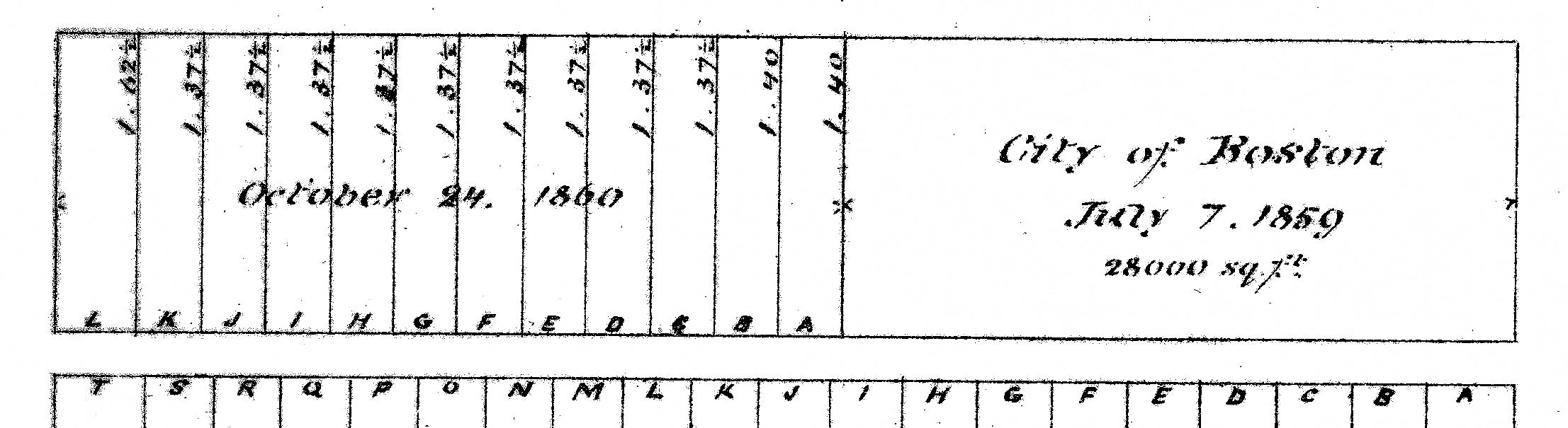
Plan of lots offered for sale at the October 24, 1860, Commonwealth of Massachusetts auction (Suffolk Co. Deed Registry, Book 778, p. 160)
Central Parcel. At its auction on October 24, 1860, the Commonwealth sold the nine lots to the west of the City of Boston’s land (Lots A-I, as shown on the plan for the auction), with a frontage of 220 feet, to Henry Lee, Jr. The land was conveyed by the Commonwealth as a single parcel on November 14, 1863, to Henry Lee, Jr. (three-fourths interest and J. Amory Davis (one-fourth interest).
Jonathan Amory Davis was president of the Suffolk National Bank. He and his wife, Frances Elizabeth (Amory) Amory lived in Dorchester. Henry Lee, Jr., was a founder and partner in the investment banking firm of Lee, Higginson & Co. and president of the Provident Institution for Savings. He and his wife, Elizabeth Perkins (Cabot) Lee, lived in Brookline.
J. Amory Davis died in May of 1865 and his interest was inherited by his daughter, Ann Wainwright Davis. On October 6, 1865, she transferred her interest in the eastern 160 feet to Henry Lee, and he transferred his interest in the western 60 feet to her. On October 14, 1865, Henry Lee, Jr., entered into an agreement with Charles Kirby to sell him the 160 foot lot, subject to Charles Kirby’s agreement to build nine houses on the land. Ultimately, Charles Kirby built five houses at 72-74-76-78-80 Marlborough on the eastern 89 feet 9 inches of the land, for speculative sale. On October 21, 1871, Henry Lee, Jr., sold Charles H. Joy the remaining 70 feet 3 inches to the west. He and his wife, Marie Louise (Mudge) Joy, built 86 Marlborough as their home. Charles Joy sold the lot to the east to his wife’s sister, Caroline Estelle (Mudge) Lawrence, and she and he husband, James Lawrence, built their home at 82 Marlborough (there is no 84 Marlborough).
On April 20, 1870, Ann Davis sold the western 12 feet of her 60 foot wide parcel to architect John H. Sturgis, who combined it with a 24 foot lot to the west he had had purchased in March of 1863 (see below). On May 18, 1871, John Sturgis sold the eastern 24 feet of his land and Ann Davis sold the western 24 feet of her remaining land to Cornelia Adelaide (Granger) Winthrop, the wife of Robert Charles Winthrop. They built their home at 90 Marlborough on the combined 48 foot lot.
Ann Davis retained the 24 foot lot to the east and, on September 7, 1871, she sold it to Susan Cabot (Jackson) Jackson, the widow of iron manufacturer Charles Jackson, Jr., who built her home at 88 Marlborough.
Western Parcels. The three lots at the western end of the block, with a frontage of 78 feet on Marlborough, were sold at the Commonwealth’s October 24, 1860, auction to David Snow, president of the Bank of the Republic and a shipping and fish merchant. The Commonwealth conveyed the land to him as a single parcel on July 30, 1862.
On March 13, 1863, David Snow sold the eastern lot, with a frontage of 24 feet, to architect John H. Sturgis. As discussed above, in April of 1870, John Sturgis acquired a 12 foot lot to the east, and then in May of 1871 sold the eastern 24 feet of his land to Cornelia Adelaide (Granger) Winthrop, the wife of Robert Charles Winthrop. He retained the 12 foot lot to the west.
On February 13, 1869, David Snow sold his remaining land, at the corner of Clarendon, with a frontage of 54 feet on Marlborough, to John Revere, agent and later treasurer and then president of his family’s firm, the Revere Copper Company. He and his wife, Susan Tilden (Torrey) Revere, lived at 156 Beacon and then 40 Commonwealth.
Building contractor George Wheatland, Jr., purchased John Revere’s land on October 1, 1869, and John Sturgis’s land on March 23, 1870. He combined the two lots and subdivided them into four lots, where he built 92 Marlborough and 263-265-267 Clarendon for speculative sale.
Original Construction. All of the buildings on the south side of Marlborough between Berkeley and Clarendon had been constructed by 1876.
The plans below illustrate when the land on the block was first sold at auction by the Commonwealth, when the Commonwealth conveyed the land (based on the dates of the deeds), and when houses were first constructed (based on dates provided in Bainbridge Bunting’s Houses of Boston’s Back Bay).
Original land sales on the south side of Marlborough between Berkeley and Clarendon
Original deeds conveying land on the south side of Marlborough between Berkeley and Clarendon
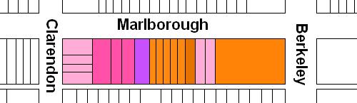
Original construction on the south side of Marlborough between Berkeley and Clarendon
Building Restrictions in Original Land Deeds
The July 7, 1859, deed to the City of Boston (Suffolk Co. Deed Registry, Book 760, p. 272) and the July 30, 1862, deed to David Snow (Book 831, p. 22) specified that any building on the land was to be “at least three stories high for the main part thereof and shall not in any event be used for a stable, or for any mechanical or manufacturing purposes;” that the front walls were to be set back twenty-two feet from Marlborough, with “steps, windows, porticos, and other usual projections appurtenant thereto” allowed in the reserved space; and that “no cellar or lower floor of any building shall be placed more than four feet below the level of the mill-dam, as fixed by the top surface of the hammered stone at the south-easterly corner of the emptying sluices.” The deeds also provided that the owners of the land would have the right to “plant and cultivate trees on the side walks” in front of their land provided that they left a distance of ten feet between the front boundary of their lots and the trees.
In November of 1858, the Commissioners on the Back Bay had voted to clarify that the prohibition on stables would not be enforced “in such a manner as to prevent the erection and use of private stables by gentlemen as appurtenances to their own dwelling homes; provided, such stables are so constructed and used as not to be justly offensive to the occupants of the surrounding buildings.” This clarification was subsequently published in the auction catalogues issued by the Commissioners, but usually was not included in the deeds.
In January of 1863, the Commissioners on Public Lands (successors to the Commissioners on the Back Bay) adopted dimensional limitations on the projections allowed in the setback area. These applied to the deeds previously executed by the Commonwealth for land on the south side of Marlborough between Berkeley and Clarendon, and were included in the November 14, 1863, deed to Henry Lee and J. Amory Davis (Suffolk Co. Deed Registry Book 860, p. 39).
Click here for more information on the restrictions contained in deeds of Back Bay land.
Original Land Deeds
The Commonwealth of Massachusetts conveyed the land on the south side of Marlborough between Berkeley and Clarendon by the following deeds:
| Address | Date | E-W | N-S | Grantee | Book | Page |
| 60-70 Marlborough | 07Jul1859 | 250’ | 112’ | City of Boston | 760 | 272 |
| 70-90 Marlborough | 14Nov1863 | 220’ | 112’ | Henry Lee, Jr. and J. Amory Davis | 860 | 39 |
| 90 Marlborough | 30Jul1862 | 78’ | 112’ | David Snow | 831 | 22 |
