The block on the south side of Beacon between Arlington and Berkeley is 596 feet in length and 112 feet from Beacon to Alley 421.
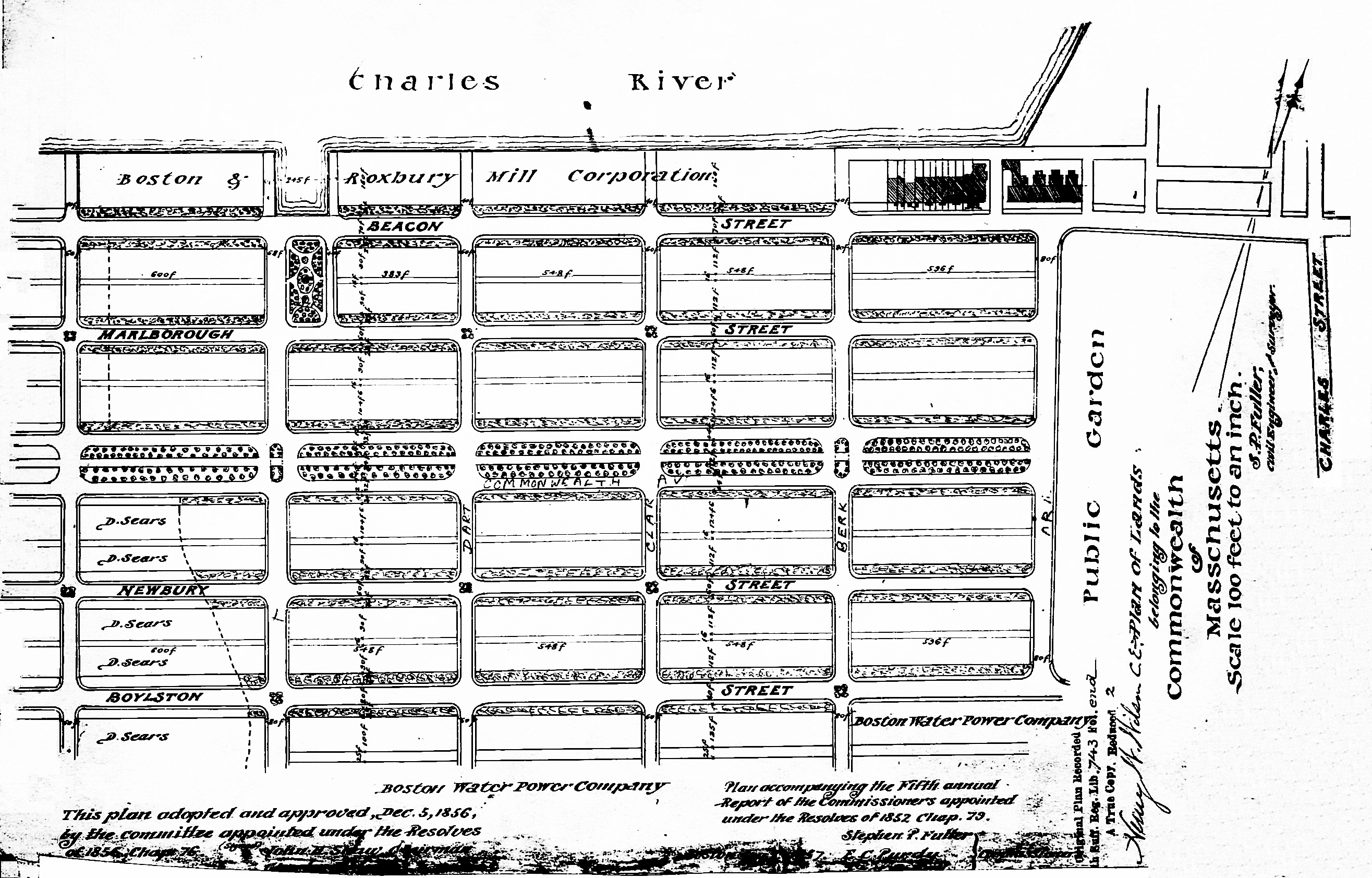
Plan of Commonwealth lands accompanying the Fifth Annual Report of the Commissioners on the Back Bay; Suffolk Co. Deed Registry, Book 743-end (recorded 31Aug1858)
The land was part of the approximately 108 acres of land in the Back Bay owned by the Commonwealth of Massachusetts.
The Commonwealth sold its land starting in 1857. The earliest transactions were by private sales negotiated by the Commissioners on the Back Bay. In 1860, the legislature required that all future sales be made through public auctions. The first auction was held on October 24, 1860, and they continued until March of 1872, when they were suspended due to depressed real estate values. In 1879, the legislature authorized the Harbor and Land Commissioners (successors to the Commissioners on the Back Bay) to sell lots with frontages of up to 100 feet by privately negotiated sale. The land sales resumed in May of 1879 and the last of the remaining land was sold in 1886.
Click here for more information on the Commonwealth of Massachusetts land in the Back Bay.
The Commonwealth sold all of the land on the south side of Beacon between Arlington and Berkeley in a privately negotiated sale on August 1, 1857, to William Warren Goddard and T. Bigelow Lawrence.
William Goddard and his wife, Harriot Miller (Erving) Goddard, lived at 99 Beacon and later at 291 Marlborough. He was a ship builder and merchant.
Timothy Bigelow Lawrence and his wife, Elizabeth (Chapman) Lawrence, lived at 97 Beacon. They previously had lived in London, where he had been an attaché with the US legation. He had resigned and returned home following the death of his father, textile manufacturer Abbott Lawrence, in August of 1855.
Unlike later deeds from the Commonwealth, the deed left the obligation of filling the land to the purchasers, and William Goddard and T. Bigelow Lawrence subsequently entered into a contract with Norman C. Munson and George Goss to fill the land (as referenced in a partnership agreement between William Goddard and T. Bigelow Lawrence dated June 12, 1858; Suffolk County Deed Registry Book 738, p. 191).
William Goddard and T. Bigelow Lawrence subsequently subdivided the land and began selling lots to individual purchasers.
They began their land sales at the two ends of the block in 1859, and then sold the parcels in-between in the early 1860s. In March of 1861, T. Bigelow Lawrence was named US Consul General to Italy. Thereafter, William Goddard probably managed their joint interests in the remaining land they owned on Beacon.
Eastern Parcels. On September 1, 1859, the partners sold the corner lot at Arlington and Beacon (with a frontage of 40 feet on Beacon) to John C. Gray, and on October 27, 1859, they sold the lot next to it (also with a frontage of 40 feet) to John Simmons. John Simmons purchased John Gray’s land on November 1, 1859, and purchased an additional 5 foot wide strip of land to the west on April 30, 1860, from William Goddard and T. Bigelow Lawrence. John Simmons subsequently had 1-2-3 Arlington built on the combined lot.
Central Parcels. On November 22, 1861, William Goddard and T. Bigelow Lawrence sold a 22 foot lot to the west of John Simmons’s land to Arthur Devens, who built his home at 101 Beacon. On the same day, they sold a 20 foot lot to the west to Samuel Tilton, who built his home at 103 Beacon.
On April 1, 1862, the partners sold a 40 foot lot to the west of Samuel Tilton’s land to George Phineas Upham, and on May 26, 1862, they sold him the 42 foot lot abutting it to the west. George Upham was a merchant and sales agent for several cotton mills. He and his wife, Sarah (Sprague) Upham, lived at 122 Beacon. He had 105-107-109-111 Beacon built for speculative sale.
In 1860 and 1861, William Goddard and T. Bigelow Lawrence entered into agreements with three separate builders to construct houses on their land at 127-129-131-133 Beacon. In each case, when the houses were completed, the partners sold the land to the builder, who then resold it, presumably recouping his costs and earning a profit.
On March 23, 1861, the partners sold 127 Beacon to James Standish, and on March 27, 1861, they sold 129 Beacon to John Dunbar. Each house was built on a 22 foot lot.
On November 29, 1860, the partners sold Samuel S. Perkins the land on which he had built 131-133 Beacon. When the houses were built, it was discovered that the western boundary did not run precisely through the middle of the party wall with 135 Beacon, built the year before. To correct this error, on November 21, 1860, the partners conveyed S. Hammond Russell, the owner of 135 Beacon, a 0.08 foot (about 1 inch) strip of land, and then conveyed Samuel S. Perkins a lot with a frontage of 49.92 feet in width. 131 Beacon and 133 Beacon each were built on 24.96 foot lots.
On July 29, 1862, T. Bigelow Lawrence sold his one-half interest in the partnership’s remaining land – a 135 foot lot between 111 Beacon and 127 Beacon – to his brother, Abbott Lawrence.
On November 12, 1862, William Goddard and Abbott Lawrence sold a 44 foot lot to the estate of Mace Tisdale. The estate built 113 Beacon as the home of Mace Tisdale’s only surviving child, Frances Ann (Tisdale) Bradlee, widow of John Rice Bradlee, and built 115 Beacon as the home of her son and daughter-in-law, dry goods merchant John Tisdale Bradlee and Sarah Elizabeth (Goddard) Bradlee.
Also on November 12, 1862, William Goddard and Abbott Lawrence sold Franklin Gibbs a 32 foot lot to the west of the land they sold the Tisdale estate. On October 13, 1863, Franklin Gibbs sold the land to his father, Nathan Bourne Gibbs, Jr., a shipping merchant in the West India trade. He and his wife, Elizabeth Swift (Burgess) Gibbs, lived at 38 Commonwealth. On March 8, 1864, he sold the eastern 22 feet 9 inches of the lot to Sarah Ward (Harrington) Freeland, the wife of merchant, cotton manufacturer, and real estate developer Charles William Freeland. They built their home at 117 Beacon.
On March 3, 1864, William Goddard and Abbott Lawrence sold Nathan Gibbs a 13 foot 6 inch lot to the west of 117 Commonwealth. He combined it with the remaining 9 feet 3 inches of his lot to the east and on March 26, 1864, he sold a 22 foot 9 inch lot to Charles Blake. On April 18, 1864, William Goddard and Abbott Lawrence sold a 29 foot 9 inch lot to the west to architect and building contractor Charles K. Kirby. He built 119 Beacon as Charles Blake’s home and a companion house 121 Beacon which he sold to Roberta (Walker) McKinney, the wife of banker Andrew McKinney.
On April 19, 1864, William Goddard and Abbott Lawrence sold the remainder of their land, between 121 Beacon and 127 Beacon, to shoe manufacturer John Wooldredge, who entered into a contract with Charles Kirby to design and build a house at 125 Beacon (there is no 123 Beacon). On July 8, 1865, Charles Kirby assigned the contract to building contractor Albert Hannibal Kelsey. On May 22, 1866, after the house was completed, John Wooldredge sold the land to Albert Kelsey, who then resold the house on September 29, 1868, to A. Louisa (Thompson) Eldridge, the wife of John Seabury Eldridge.
As conveyed by the partners to John Wooldredge, the lot at 125 Beacon was 22.58 feet on Beacon and 22.50 feet on the alley. These dimensions probably were intended to adjust for anomalies in the party walls with 121 Beacon and 127 Beacon. However, compensating adjustments were not reflected in the deeds for those houses and, as a result, there is about a 2-1/8th inch discrepancy on Beacon and a 3 inch discrepancy on the alley when the length of the block as shown in the original land deed (596 feet) is compared with the total frontages shown in the deeds for the individual lots on the block (595.83 feet on Beacon and 595.75 feet on the alley).
Western Parcels. On September 1, 1859, William Goddard and T. Bigelow Lawrence sold the lot at 135 Beacon to S. Hammond Russell and the lot at 137 Beacon to his aunt, Catherine (Hammond) Gibson, the widow of John Gardiner Gibson. They each built their homes on the land. As originally conveyed, both lots were 22 feet wide. As discussed above. the house at 135 Beacon was built so that the eastern boundary did not run precisely through the middle of the party wall and on November 21, 1860, William Goddard and T. Bigelow Lawrence conveyed an additional 0.08 feet (about 1 inch) to S. Hammond Russell.
On September 15, 1859, William Goddard and T. Bigelow Lawrence sold the remainder of their land at the western end of the block, with a frontage of 114 feet on Beacon, to shipping merchant and real estate investor John Lowell Gardner. He and his wife, Catharine Elizabeth (Peabody) Gardner, lived at 7 Beacon, and would build a new home at 182 Beacon in the mid-1860s.
On January 20, 1860, John L. Gardner sold a 20 foot lot to the west of 137 Beacon to George Phineas Upham, and on January 25, 1860, he sold the 22 foot lot next to it to Eunice Hooper and her sister, Mary Ingalls Hooper. 139-141 Beacon were built as a symmetrical pair of houses, 139 Beacon for speculative sale by George Upham, and 141 Beacon as the home of the Misses Hooper.
John L. Gardner built 143-145-147 Beacon (303 Berkeley) on the remaining land. He leased 143 Beacon to Matthias Ellis and his wife, Sarah Seymour (Forsyth) Ellis, until about 1867, when it became the home of John L. Gardner’s brother-in-law and sister, Horace Gray and Sarah Russell (Gardner) Gray. 145 Beacon was the home of his son-in-law and daughter, attorney Joseph Randolph Coolidge and Julia (Gardner) Coolidge. And 147 Beacon (303 Berkeley) was the home of John L. Gardner’s son and daughter-in-law, Joseph Peabody Gardner and Harriet Sears (Amory) Gardner.
Original Construction. All of the houses on the south side of Beacon between Arlington and Berkeley had been built by 1866.
The plan below illustrates when houses were first constructed based on dates provided in Bainbridge Bunting’s Houses of Boston’s Back Bay.

Original construction on the south side of Beacon between Arlington and Berkeley
Building Restrictions in Original Land Deeds
The August 1, 1855, deed from the Commonwealth of Massachusetts (Suffolk Co. Deed Registry Book 742, p. 159) specified that the land was to be “occupied by first class dwelling houses without stables;” that the front walls were to be set back twenty-two feet from Beacon, with “steps, windows, porticos, and other usual projections appurtenant to dwelling houses” allowed in the reserved space; and that “no cellar or lower floor of any building shall be placed more than four feet below the level of the mill-dam, as fixed by the top surface of the hammered stone at the south-easterly corner of the emptying sluices.” The deed also provided that the owners of the land would have the right to “plant and cultivate trees on the side walks” in front of their land provided that they left a distance of ten feet between the front boundary of their lots and the trees.
Unlike later deeds from the Commonwealth, the deed did not require that the buildings be at least three stories high.
In November of 1858, the Commissioners on the Back Bay voted to clarify that the prohibition on stables would not be enforced “in such a manner as to prevent the erection and use of private stables by gentlemen as appurtenances to their own dwelling homes; provided, such stables are so constructed and used as not to be justly offensive to the occupants of the surrounding buildings.”
In January of 1863, the Commissioners on Public Lands (successors to the Commissioners on the Back Bay) adopted dimensional limitations on the projections allowed in the setback area. These applied to the deed previously executed by the Commonwealth for land on the south side of Beacon between Arlington and Berkeley.
Click here for more information on the restrictions contained in deeds of Back Bay land.
Original Land Deeds
The Commonwealth of Massachusetts conveyed the land on the south side of Beacon between Arlington and Berkeley by the following deed:
| Address | Date | E-W | N-S | Grantee | Book | Page |
| 1-3 Arlington
101-145 Beacon 303 Berkeley |
01Aug1857 | 596’ | 112’ | William W. Goddard and T. Bigelow Lawrence | 724 | 159 |
