The block on the south side of Commonwealth between Exeter and Fairfield is 600 feet in length and 124 feet 6 inches from Commonwealth to Alley 433.
The eastern 262 feet of the block were part of the approximately 108 acres of land owned by the Commonwealth of Massachusetts. The western 338 feet on the block were part of the lands owned by the David Sears family.
The boundary line between the lands was about where the western wall of 214 Commonwealth is today (the eastern 22.5 feet of 214 Commonwealth is on former Commonwealth land, and the western 1.5 feet on former Sears land).
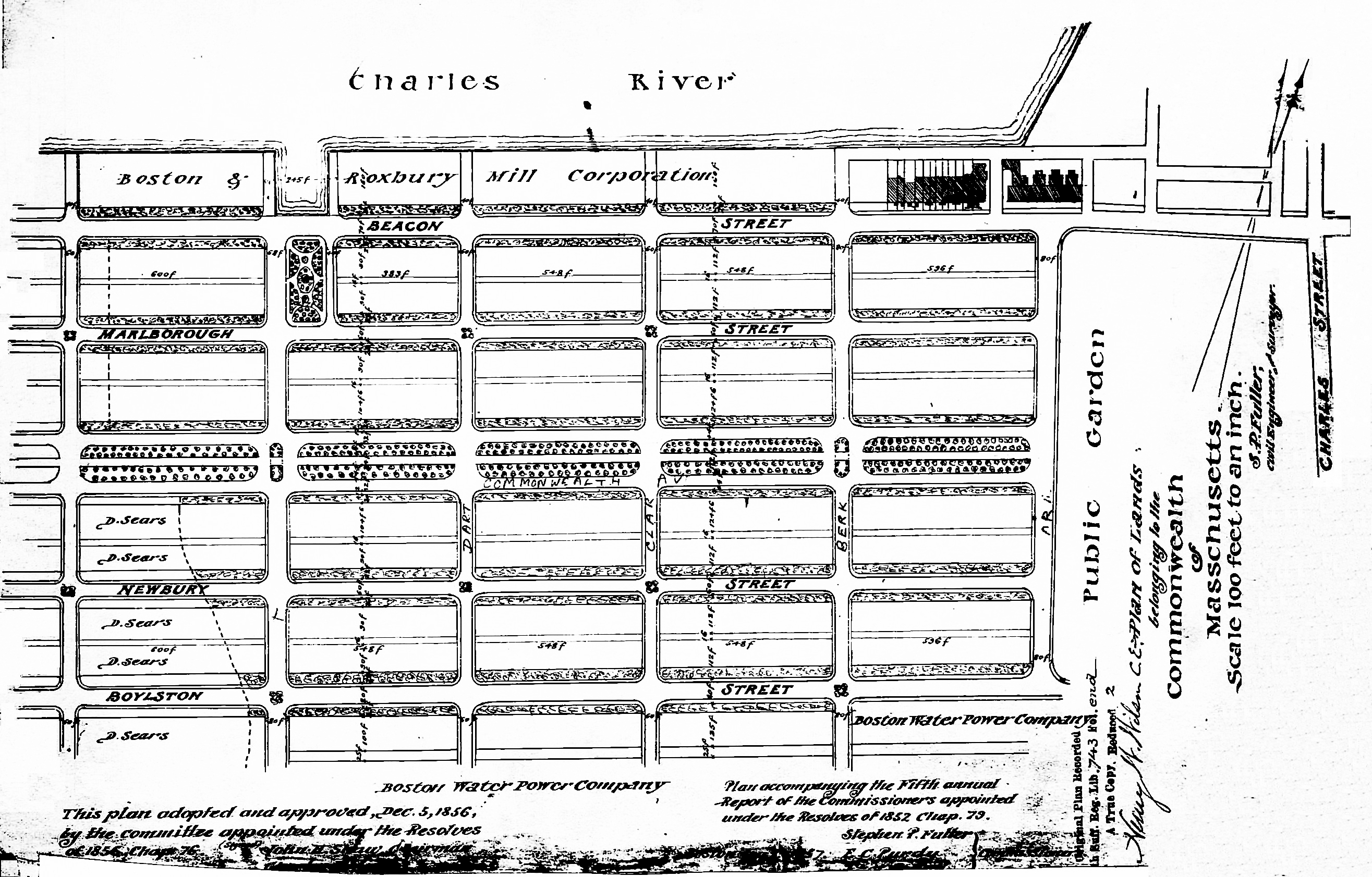
Plan of Commonwealth lands, 5Dec1856 (Suffolk Co. Deed Registry, Book 743, end of book)
Commonwealth of Massachusetts Land. The Commonwealth sold its land starting in 1857. The earliest transactions were by private sales negotiated by the Commissioners on the Back Bay. In 1860, the legislature required that all future sales be made through public auctions. The first auction was held on October 24, 1860, and they continued until March of 1872, when they were suspended due to depressed real estate values. In 1879, the legislature authorized the Harbor and Land Commissioners (successors to the Commissioners on the Back Bay) to sell lots with frontages of up to 100 feet by privately negotiated sale. The land sales resumed in May of 1879 and the last of the remaining land was sold in 1886.
Click here for more information on the Commonwealth of Massachusetts land in the Back Bay.
The Commonwealth sold its land on the south side of Commonwealth between Exeter and Fairfield through privately-negotiated sales in 1879, 1880, 1881, and 1884. The land comprised a corner lot at Exeter and nine lots further west.

Excerpt from plan of land sales through 1879, showing price paid per s.f.; 1879 Harbor and Land Commissioners Report
A plan accompanying the 1879 Harbor and Land Commissioners Report showing all of the land sales through 1879 indicated that the corner lot (Lot 1) was sold on November 3, 1879, two lots in the middle of the block (Lots 5 and 6) and the next-to-last lot to the west (Lot 9) were sold on October 25, 1879, and the last lot to the west (Lot 10), at the boundary with the Sears family’s land, was sold on May 26, 1879. Neither the map nor the report identifies the names of the purchasers, and there does not appear to have been a news account of their sale.
In their annual reports for 1880, 1881, and 1884, the Harbor and Land Commissioners reported that 9,773.24 square feet of land on the block were sold in 1880 (Lots 2, 3, and 4 based on subsequent deeds and the 1883 Bromley map); 3174.75 s. f. were sold in 1881 (Lot 8 based on the 1883 Bromley map), and 3,237 s. f. were sold in 1884 (Lot 7). The names of the purchasers were not given nor do they appear to have been reported in the press.
Sears Family Land. The David Sears family land extended south from a line down the middle of Commonwealth, bounded on the east by the Commonwealth’s lands and on the west by the Boston Water Power Company’s lands. The boundary with the Boston Water Power Company ran southwest at approximately a 45 degree angle from a point on the south side of Commonwealth 134.66 feet west of Hereford (324 Commonwealth straddles the line). The Sears family land extended south by an irregular line past Boylston to about St. James Street.
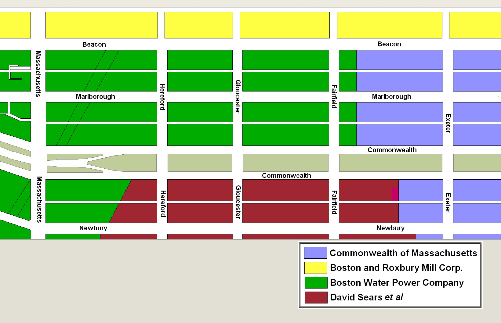
Original owners of land in the residential portion of the Back Bay. drawn on the block plan for the residential portion of the neighborhood.
The Sears family sold all of its land on January 2, 1871, to Nathan Matthews. He was a real estate investor and developer, and served as president of the Boston Water Power Company from 1860 to 1870. He and his wife, Albertine (Bunker) Matthews, lived at 12 Arlington.
On October 16, 1873, Nathan Matthews conveyed the land to a trust he had formed with Henry D. Hyde and Grenville T. W. Braman.
Henry Dwight Hyde was an attorney. He and his wife, Luvan Augusta (Charles) Hyde, lived at 153 West Newton and later at 380 Commonwealth. Grenville Temple Winthrop Braman was a real estate investor and served as treasurer of the Boston Water Power Company until mid-1869 (at the same time as Nathan Matthews was president). He and his wife, Susie A. (Davies) Braman, lived at 9 Brimmer and later at 447 Beacon.
On November 19, 1875, the trustees terminated the trust and the land was distributed to individual owners.
The land between the boundary with the Commonwealth and Fairfield was received from the trust by Nathan Matthews, and on May 18, 1876, he sold it to the National Bank of Commerce of Boston.
Click here for more information on the Sears family land in the Back Bay.
Eastern and Central Parcels. The plan filed with the 1879 Harbor and Land Commissioners Report indicates that the Commonwealth sold the 30 foot corner lot at Exeter on November 3, 1879. Nathan Matthews probably was the buyer. He subsequently had 25 Exeter built on the land, and when it was completed the land was purchased from the Commonwealth by Margaret (Chapin) Bliss, the wife of William Bliss, who presumably acquired Nathan Matthews’s right to purchase the land and paid him separately for the house.
The Commonwealth sold the three lots to the west (Lots 2-4) in 1880 by privately negotiated contracts.
The contract for Lot 2 probably was with architect John Hubbard Sturgis, who purchased and took title to the land on May 13, 1881, and sold it the same day to Elizabeth Elliot (Torrey) Spooner, the widow of Daniel Nicolson Spooner. She built her home at 196 Commonwealth.
The contracts for Lots 3 and 4 probably were with Annie Bolton (Fay) Matthews, the wife of William A. Matthews, Jr. (not closely related to Nathan Matthews). She purchased and took title to Lot 3 on June 21, 1880, and to the eastern six inches of Lot 4 on December 23, 1880. The Matthewses subsequently built their home at 198 Commonwealth, with the western party wall entirely on their land.
On July 24, 1882, Annie Matthews sold the western six inches, with the western half of the party wall on it, to John James French. He and his wife, Frances Maria (Stratton) French, built their home at 200 Commonwealth and on October 2, 1883, after it was completed, he purchased the remaining 25.5 feet of the land from the Commonwealth (presumably having acquired the right to purchase it from Annie Matthews).
The two lots to the west (Lots 5-6) had been sold by the Commonwealth on October 25, 1879, by privately negotiated contracts.
It appears likely that the contract for Lot 5 was with John J. French’s mother-in-law, Sarah Hollis (Piper) Stratton, the widow of Charles Edwin Stratton, who built her home at 202 Commonwealth. On July 12, 1883, after it was completed, she purchased the land from the Commonwealth.
The contract for Lot 6 may have been with Andrew G. Greeley, who purchased the land on April 28, 1885. He sold it on April 30, 1885, to Charles Wallingford Parker, a retail clothier, and on January 22, 1886, it was purchased from him by real estate dealer Henry Whitwell. He subsequently had 204 Commonwealth built for speculative sale.
On December 2, 1884, the Commonwealth sold the eastern 25 feet of Lot 7 to Nancy (Flagg) Flagg, the widow of wine merchant Dennis Francis Flagg, and sold the western one foot to Charles Edwin Stratton, Jr., an attorney who lived with his widowed mother at 202 Commonwealth. Nancy Flagg built her home at 206 Commonwealth.
On November 6, 1884, the Commonwealth sold Alexander B. Wilbor the lot to the west (Lot 8) and, on May 15, 1885, he sold the lot to Henry Clay Jackson. The next day, Henry Jackson purchased Charles Stratton’s one foot strip to the east, and on June 4, 1885, he purchased a six inch strip to the west, including the eastern half of the party wall with 212 Commonwealth, from Benjamin W. Munroe. Henry Jackson and his wife, Maria Amanda (Moulton) Jackson, subsequently built 208 Commonwealth as their home.
The Commonwealth entered into an agreement to sell the 26 foot lot to the west (Lot 9) on October 25, 1879. The contract probably was with Benjamin Warren Munroe, who held the right to purchase the land by January 24, 1880, when he entered into an agreement with George Quincy, owner of the house at 214 Commonwealth, to purchase a six inch strip of land with the eastern half of the party wall on it. Benjamin Munroe subsequently built his home at 212 Commonwealth (there is no house numbered 210 Commonwealth). On June 2, 1885, several years after 212 Commonwealth was completed, he purchased the land from the Commonwealth. As noted above, two days later he sold a six inch strip to the east, with the eastern half of the party wall on it, to Henry C. Jackson, and on June 18, 1885, he purchased the six inch strip to the west (with half of the party wall with 214 Commonwealth on it) from George Quincy, consistent with their agreement five years earlier.
The Commonwealth sold the 23 foot lot furthest west (Lot 10) on May 26, 1879. As discussed above, the 1879 Harbor and Land Commissioners Report did not indicate the name of the purchaser and the deed was not executed until several years later. However, the purchaser either was George Quincy or, if not, by late 1879 he had acquired the right to purchase the land from the original purchaser.
On November 21, 1879, George Quincy purchased a 1.5 foot strip of land to the west from James Barr Ames, increasing his lot to 24.5 feet, and on January 24, 1880, he entered into the agreement with Benjamin Munroe to sell him the eastern six inches. James Barr Ames’s father, building contractor Samuel Tarbell Ames, subsequently built 214 Commonwealth on the land as George Quincy’s home. On May 22, 1882, George Quincy took title to the 23 foot lot from the Commonwealth, and on June 18, 1885, he transferred the six inch strip to the east to Benjamin Munroe.
Central and Western Parcels. The western 1.5 foot strip purchased by George Quincy was at the eastern edge of the land originally owned by the Sears family. As noted above, Nathan Matthews had acquired all of their land on January 2, 1871, and had sold all of his holdings on the south side of Commonwealth between Exeter and Fairfield to the National Bank of Commerce of Boston on May 18, 1876. The bank sold all of its land on the block in 1879 and 1880.
On April 8, 1879, the bank sold the western 49.5 feet of the land to George Henry Mackay. He subdivided it into two 24 foot lots and sold the remaining 1.5 feet to the east to Samuel Barr Ames on September 4, 1879, who sold it to George Quincy two months later. George Mackay had 216-218 Commonwealth built on the two 24 foot lots. He sold 216 Commonwealth to Gertrude (Horsford) Fiske, the wife of Andrew Fiske, and retained 218 Commonwealth as his home.
On April 26, 1879, the National Bank of Commerce sold the 24 foot lot to the west of the land it sold George Mackay to his father, Robert Caldwell Mackay, He built his home at 220 Commonwealth.
On May 10, 1879, the bank sold the 25 foot lot to the west of Robert Mackay’s land to Benjamin F. Guild, who built his home at 222 Commonwealth, and on October 11, 1879, it sold the 25 foot lot west of that to Freeman J. Doe, who built his home at 224 Commonwealth.
On November 11, 1879, the bank sold the 26 foot lot west of Freeman Doe’s land to Henry Detrick Yerxa. He sold the western one foot on March 31, 1881, to Charles Wallingford Parker, and the eastern 25 feet on October 1, 1881, to Charles Henry Hayden, who built his home at 226 Commonwealth.
The three lots west of Henry Yerxa’s land were sold by the bank to building contractor George Wheatland, Jr., in March and April of 1880, He sold all three lots on the same day he purchased them.
Charles W. Parker purchased the eastern two lots, a 24 foot lot and a 19 foot lot, on March 10, 1880, and April 16, 1880. He combined them with the one foot strip he acquired from Henry Yerxa and built 228 Commonwealth on a 24 foot lot and 230 Commonwealth on a 20 foot lot. He kept 228 Commonwealth as his home and sold 230 Commonwealth on June 21, 1883, to Susan Esther (Piper) Taggard, the wife of Bartholomew W. Taggard.
Fannie Smart (Coverly) Wheelock, the wife of Austin Augustus Wheelock, purchased George Wheatland, Jr.’s, western lot, with a 20 foot frontage, on March 20, 1880. The Wheelocks built 232 Commonwealth as their home.
The National Bank of Commerce sold the 24 foot lot to the west of 232 Commonwealth on April 14, 1880, to Emma Frances (Ober) Perkins, the wife of investment banker Aaron Ward Perkins.
Six months earlier, on October 18, 1879, it had sold the 22.5 foot lot next to it to Mary (Willian) Alden Wadleigh, the wife of Horace W. Wadleigh, and the Wadleighs built their home at 236 Commonwealth. Emma Perkins had not built on her land the east, and on June 19, 1889, Mary Wadleigh bought the lot and built 234 Commonwealth. The Wadleighs moved to the new house and sold 236 Commonwealth.
In May of 1879 or earlier, the National Bank of Commerce entered into agreements to sell the 20 foot lot west of 236 Commonwealth and the 29 foot lot next to it. On May 7, 1879, Charles B. Wilson filed a permit application to build 238 Commonwealth on the eastern lot, and on the same day, Dr. William Henry Baker filed an application to build 240 Commonwealth on the western lot. After the buildings were substantially complete, they acquired the land from the bank: William Baker’s wife, Charlotte Ann (Ball) Baker, purchased the land for 240 Commonwealth on August 19, 1879, and Charles Wilson’s wife, Sarah D. (Turner) Wilson, purchased the land for 238 Commonwealth on August 24, 1880.
On May 14, 1879, the bank sold the corner lot at Fairfield, with a 30 foot frontage on Commonwealth, to William Saltonstall. He built 30 Fairfield as his home.
Original Construction. All of the buildings on the south side of Commonwealth between Exeter and Fairfield had been built by 1889.
The plans below illustrate when the land on the block was first sold by the Commonwealth or the Sears family, when the Commonwealth or the National Bank of Commerce of Boston conveyed the land (based on the dates of the deeds), and when houses were first constructed (based on building permit applications, news reports, and dates provided in Bainbridge Bunting’s Houses of Boston’s Back Bay).

Original land sales on the south side of Commonwealth between Exeter and Fairfield

Original deeds conveying land on the south side of Commonwealth between Exeter and Fairfield

Original construction on the south side of Commonwealth between Exeter and Fairfield

Building Restrictions in Original Land Deeds
The deeds from the Commonwealth included identical language specifying that any building on the land was to be “at least three stories high for the main part thereof and shall not in any event be used for a stable, or for any mechanical, mercantile, or manufacturing purposes;” that the front walls were to be set back twenty feet from Commonwealth, with “steps, windows, porticos, and other usual projections appurtenant thereto” allowed in the reserved space subject to dimensional limitations enumerated in the deed; and that “no cellar or lower floor of any building shall be placed more than four feet below the level of the mill-dam, as fixed by the top surface of the hammered stone at the south-easterly corner of the emptying sluices.” The deed also provided that the owners of the land would have the right to “cultivate trees on the side walks” in front of their land provided that they left a distance of ten feet between the front boundary of their lots and the trees.
In November of 1858, the Commissioners on the Back Bay had voted to clarify that the prohibition on stables would not be enforced “in such a manner as to prevent the erection and use of private stables by gentlemen as appurtenances to their own dwelling homes; provided, such stables are so constructed and used as not to be justly offensive to the occupants of the surrounding buildings.” This clarification was subsequently published in the auction catalogues issued by the Commissioners, but usually was not included in the deeds.
Neither the deed from the David Sears family to Nathan Matthews, nor the deed from Nathan Matthews to the National Bank of Commerce of Boston contained any language restricting the type or physical characteristics of buildings built on the land.
However, on June 12, 1876, the owners of all of the land between Commonwealth and Newbury from the boundary with the Commonwealth’s land on the east and Gloucester on the west entered into an agreement (Book 1330, p. 300) establishing a twenty foot setback on Commonwealth and a twenty-two foot setback on Newbury, with “steps, windows, porticos, and other usual projections appurtenant thereto” allowed in the reserved space subject to dimensional limitations enumerated in the deed, which were the same as those included in the Commonwealth’s deeds. The agreement also provided for the creation of a sixteen foot passageway between the Commonwealth and Newbury blocks, consistent with the alleys laid out by the Commonwealth.
The 1876 agreement did not include the language contained in the Commonwealth’s deeds requiring that buildings be of a certain height, nor did it prohibit the use of buildings for stables, nor for any mechanical, mercantile, or manufacturing purposes. A some subsequent deeds by individual landowners did, however, specify limitations on stables.
Click here for more information on the restrictions contained in deeds of Back Bay land.
Original Land Deeds
The Commonwealth of Massachusetts conveyed its land on the south side of Commonwealth between Exeter and Fairfield by the following deeds:
| Address | Date | E-W | N-S | Grantee | Book | Page |
| 25 Exeter | 06May1884 | 31’ | 124.5’ | Margaret C. Bliss, wife of William Bliss | 1636 | 546 |
| 196 Commonwealth | 13May1881 | 26’ | 124.5’ | John H. Sturgis | 1525 | 51 |
| 198 Commonwealth | 21Jun1880 | 26’ | 124.5’ | Annie B. Matthews, wife of William Matthews | 1496 | 460 |
| 200 Commonwealth | 23Dec1880 | 0.5’ | 124.5’ | Annie B. Matthews, wife of William Matthews | 1512 | 229 |
| 200 Commonwealth | 02Oct1883 | 25.5’ | 124.5’ | John J. French | 1613 | 337 |
| 202 Commonwealth | 12Jul1883 | 26’ | 124.5’ | Sarah H. Stratton | 1606 | 97 |
| 204 Commonwealth | 28Apr1885 | 26’ | 124.5’ | Andrew G. Greeley | 1675 | 392 |
| 206 Commonwealth | 02Dec1884 | 25’ | 124.5’ | Nancy Flagg | 2812 | 166 |
| 208 Commonwealth (confirmatory deed) | 02Dec1884 (confirmed 10Apr1924) | 1’ | 124.5’ | Charles E. Stratton | 4569 | 25 |
| 208 Commonwealth | 06Nov1884 | 26’ | 124.5’ | Alexander B. Wilbor | 1659 | 99 |
| 208-212 Commonwealth | 02Jun1885 | 26’ | 124.5’ | Benjamin W. Munroe | 1680 | 92 |
| 214 Commonwealth | 22May1882 | 23’ | 124.5’ | George Henry Quincy | 1562 | 436 |
On January 2, 1871, the Sears family sold all of its land Nathan Matthews (Book 1029, p. 233), including land on the south side of Commonwealth bounded on the east by the Commonwealth’s lands at a point 262 feet west of Exeter and bounded on the west by the Boston Water Power Company’s lands by a line that ran southwest at approximately a 45 degree angle, starting at a point on the south side of Commonwealth 134.66 feet west of Hereford. The land extended south by an irregular line past Boylston to about St. James Street.
On the same day Nathan Matthews conveyed the land on the south side of Commonwealth and north side of Newbury between the boundary with the Commonwealth’s lands and Fairfield to Franklin Haven (Book 1029, p. 239); and conveyed the land on the south side of Commonwealth and the north side of Newbury between Fairfield and the Boston Water Power Company boundary to David N. Skillings, trustee (Book 1029, p. 238). On February 8, 1871, Franklin Haven conveyed the land east of Fairfield back to Nathan Matthews (Book 1034, p. 56), and Nathan Matthews transferred it to David N. Skillings, trustee (Book 1034, p. 84).
On May 30, 1873, David N. Skillings sold all of the land he previously purchased from Nathan Matthews back to him (Book 1163, p. 259). On October 16, 1873, Nathan Matthews transferred the land to attorney Harvey N. Shepard (Book 1182, p. 270) who conveyed it on the same day to Nathan Matthews, Henry D. Hyde, and Grenville T. W. Braman, as trustees of a real estate investment trust (Book 1182, p. 271).
On November 19, 1875, the trustees terminated the trust and transferred the land back to Harvey N. Shepard (Book 1303, p. 157), who conveyed the land on the same day to individual owners, including conveying the parcel between the boundary with the Commonwealth of Massachusetts and Fairfield to Nathan Matthews (Book 1303, p. 207). Nathan Matthews conveyed the land to the National Bank of Commerce of Boston on May 18, 1876 (Book 1329, p. 62). On June 28, 1878, William Grover foreclosed on a mortgage he held on the property and sold his interest to the bank (Book 1427, p. 49).
The National Bank of Commerce of Boston conveyed the land on the south side of Commonwealth between Exeter and Fairfield by the following deeds:
| Address | Date | E-W | N-S | Grantee | Book | Page |
| 214-216 Commonwealth | 07Apr1879 | 49.5’ | 124.5’ | George Henry Mackay | 1455 | 124 |
| 220 Commonwealth | 26Apr1879 | 24’ | 124.5’ | Robert C. Mackay | 1455 | 169 |
| 222 Commonwealth | 10May1879 | 25’ | 124.5’ | Benjamin F. Guild | 1456 | 133 |
| 224 Commonwealth | 11Oct1879 | 25’ | 124.5’ | Freeman J. Doe | 1472 | 148 |
| 226 Commonwealth | 01Nov1879 | 26’ | 124.5’ | Henry D. Yerxa | 1475 | 18 |
| 228-230 Commonwealth | 10Mar1880 | 24’ | 124.5’ | George Wheatland, Jr. | 1486 | 9 |
| 230 Commonwealth | 16Apr1880 | 19’ | 124.5’ | George Wheatland, Jr. | 1489 | 449 |
| 232 Commonwealth | 20Mar1880 | 20’ | 124.5’ | George Wheatland, Jr. | 1486 | 306 |
| 234 Commonwealth | 14Apr1880 | 24’ | 124.5’ | Emma Frances Perkins, wife of Aaron W. Perkins | 1489 | 161 |
| 236 Commonwealth | 18Oct1879 | 22.5’ | 124.5’ | Mary W. Wadleigh, wife of Horace W. Wadleigh | 1473 | 4 |
| 238 Commonwealth | 24Apr1880 | 20’ | 124.5’ | Sarah D. Wilson, wife of C. B. Wlson | 1490 | 38 |
| 240 Commonwealth | 19Aug1879 | 29’ | 124.5’ | Charlotte A. Baker, wife of William H. Baker | 1475 | 10 |
| 30 Fairfield | 14May1879 | 30’ | 124.5’ | William G. Saltonstall | 1456 | 301 |
