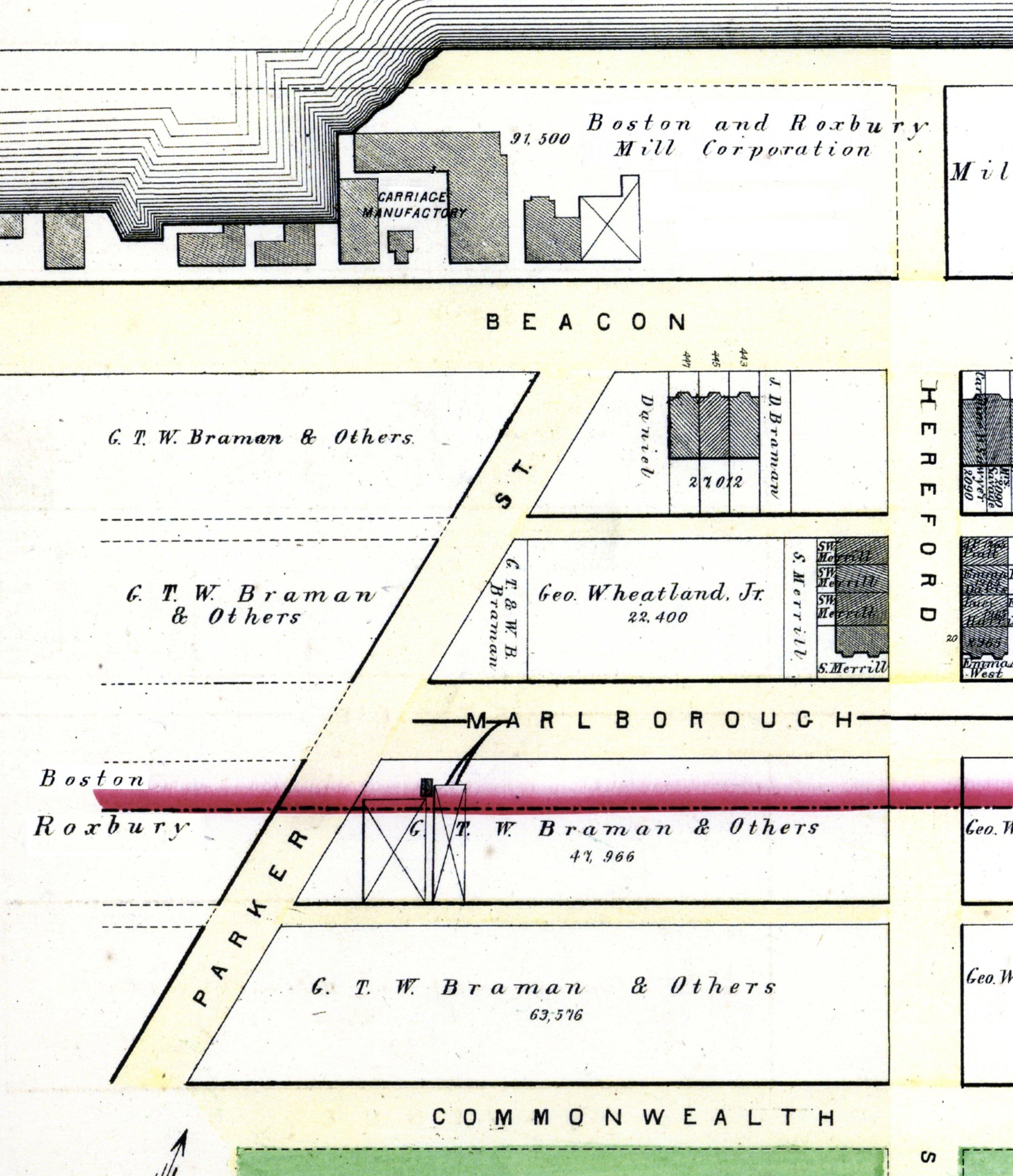
The block on the south side of Beacon between Hereford and Massachusetts Avenue (formerly West Chester Park) is 640 feet in length and 112 feet from Beacon to Alley 414.
The land was part of the Boston Water Power Company’s land in the residential portion of the Back Bay, which included all of the land from the south side of Beacon to the north side of Commonwealth west of the Commonwealth’s lands by a line about 95 feet east of what is now Fairfield Street. The company also owned the land on the south side of Commonwealth west of a point about 135 feet west of Hereford. The land to the east was owned by the Sears family.
The company sold all its land in large parcels, almost exclusively to real estate investment trusts which then subdivided the land and resold it. It sold land in 1863, 1866, 1868, and 1872, by which point it had sold all of its land between the Commonwealth’s lands and a line 125 feet west of Massachusetts Avenue (West Chester Park). It sold the remainder of its land in the residential portion of the neighborhood in 1880.
Click here for more information on the Boston Water Power Company land in the Back Bay.
Parker Street as shown on the 1874 Hopkins map
Originally, the south side of Beacon between Hereford and Massachusetts Avenue was divided by Parker Street, a 60 foot wide street located on top of the Cross Dam. The east side of the street intersected with Beacon at a point about 210 feet west of Hereford. It ran southwest at approximately a 45 degree angle, intersecting Marlborough, Commonwealth, Newbury, and Boylston, and then continuing to Centre Street. Various manufacturing and industrial businesses had been located on the street to utilize the tidal power provided by the dam before its operation was terminated.
On June 20, 1866, all of the land on the block from the east side of Parker Street to Hereford was purchased from the Boston Water Power Company by Daniel Davies.
Daniel Davies was a housewright and master carpenter. In the 1860s, he and his wife, Amity Bacon (Hastings) Davies, lived at 68 Charles and later at 91 Charles.
On March 1, 1872, all of the land on the block from the west side of Parker Street to Massachusetts Avenue was purchased by a real estate investment trust formed by Grenville T. W. Braman, Henry D. Hyde, and Frank W. Andrews, known as the Beacon Street Lands Trust. The trust also purchased a number of other parcels from the Boston Water Power Company at the same time.
Grenville Temple Winthrop Braman was a real estate investor and served as treasurer of the Boston Water Power Company until mid-1869. His wife, Susie A. (Davies) Braman, was the daughter Daniel and Amity Davies. The Bramans lived at 9 Brimmer.
Henry Dwight Hyde was an attorney. He and his wife, Luvan Augusta (Charles) Hyde, lived at 153 West Newton and later would live at 380 Commonwealth. Frank William Andrews was a real estate investor and former importer of iron and crockery. He and his wife, Maria Frances (Adams) Andrews, lived at 6 Marlborough.
In 1872-1873, Daniel Davies built three houses at 443-445-447 Beacon. 443 Beacon became the home of Grenville Braman’s brother and business partner, Jarvis Dwight Braman, and his wife, Amelia Coverley (Finnegan) Braman; 445 Beacon became Daniel and Amity Davies’s home; and 447 Beacon became Grenville and Susie Braman’s home. In 1876, Daniel Davies built a fourth house at 449 Beacon. He left a vacant lot at the corner of Beacon and Hereford with a 78 foot frontage on Beacon and a 112 foot frontage on Hereford.
In 1877, Parker Street between Beacon and Boylston was discontinued as a public thoroughfare. Daniel Davies and Grenville T. W. Braman joined with the Beacon Street Lands Trust to acquire the roadway between Beacon and Commonwealth Avenue from the Commonwealth on June 1, 1877, and to acquire the land under the roadway from the Boston Water Power Company on April 30, 1878.
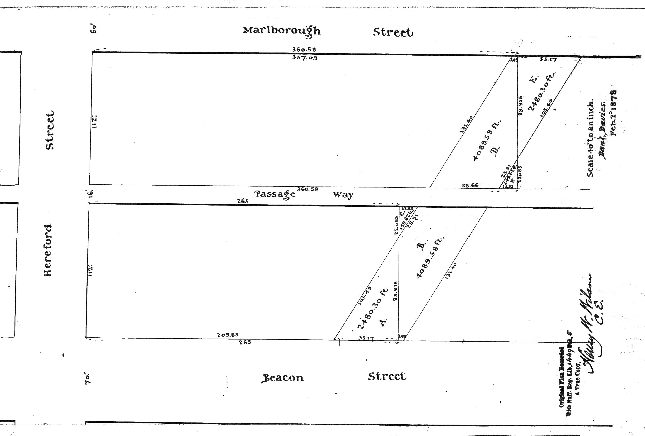
1879 Plan of Parker Street between Beacon and Marlborough, with triangular lots to “square off” the parcels; Suffolk County Deed Registry, Book 1449, p. 5
Daniel Davies died in June of 1878, and on February 1, 1879, his heirs and the Beacon Street Lands Trust entered into a series of transactions (using Chester M. Dawes as conveyancer) to “square off” their holdings by exchanging triangular shaped lots, resulting in a north-south dividing line 265 feet west of Hereford.
On February 1, 1879, Daniel Davies’s heirs sold the western 16 feet 3 inches of their land – abutting the land owned by the Beacon Street Lands Trust – to Grenville Braman’s brother, George H. Braman. On October 24, 1879, Daniel Davies’s heirs sold the lot at the corner of Beacon and Hereford to Edwin Markland White, who re-sold it to real estate dealer Samuel Horatio Whitwell. Samuel Whitwell and his brother and partner, Henry Whitwell, built 435 Beacon and 7-9-11 Hereford on the lot.
In January and February of 1880, architect John Hubbard Sturgis purchased all of the land between 449 Beacon (the west side of which was 198 feet west of Hereford) and Massachusetts Avenue, including the remaining land owned by the Daniel Davies estate (50 feet 3 inches), the lot owned by George Braman (16 feet 9 inches), and the land owned by the Beacon Street Lands Trust (375 feet). The resulting parcel had a frontage of 442 feet.
Over the next eight years, John H. Sturgis sold the lots between 451 Beacon and 465 Beacon to various buyers. He died in February of 1888, and his widow, Frances Anne (Codman) Sturgis, sold the remainder of the land to the west between 1888 and 1896.
The houses built at 451-453-455-457-459-461 Beacon were partially built on land that previously had been Parker Street, with the Cross Dam below.
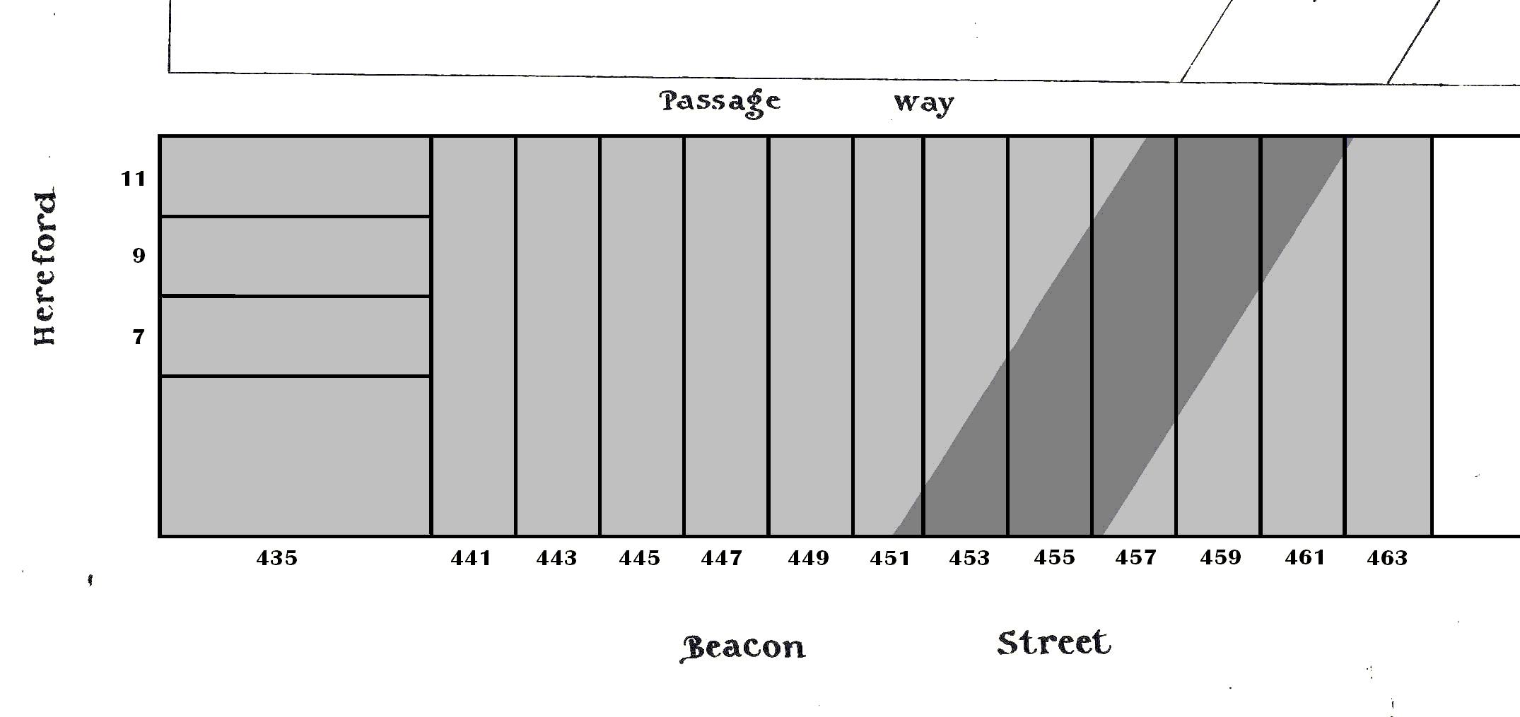
South side of Beacon showing lots for 435-463 Beacon and 7-11 Hereford, with area where Parker Street formerly was located
Building Restrictions in Original Land Deeds
The June 20, 1866, original land deed from the Boston Water Power Company to Daniel Davies included requirements that buildings be built of brick, stone, or iron; buildings be “at least two stories high for the main part thereof, including basement and attic;” and that buildings not be used for a livery stable or for any mechanical or manufacturing purpose. The deed also required that buildings be set back twenty-two feet from Beacon, provided that doors, porticos, windows, and roof cornices were allowed to project into the reserved space with depth and dimensional limitations similar to those required by the Commonwealth of Massachusetts deeds conveying its lands (as expanded upon by the regulations of the Commissioners on Public Lands).
The March 1, 1872, original land deed from the Boston Water Power Company to the Beacon Street Lands Trust, which included several tracts of land, included requirements that buildings be built of brick, stone, or iron; that buildings be not less than three stories in height including the basement; and that buildings not be used for a livery stable or for any mechanical or manufacturing purpose. The deed not include any requirement that houses be set back a specified distance from Beacon.
When the Beacon Street Lands Trust conveyed their land to John Sturgis on January 24, 1880, the deed repeated these restrictions and added a requirement that buildings be set back twenty-two feet from Beacon, provided that doors, porticos, windows, and roof cornices were allowed to project into the reserved space with depth and dimensional limitations.
Original Land Deeds
The Boston Water Power Company sold its land on the south side of Beacon between Hereford and Massachusetts Avenue by the following deeds:
| Address | Description | Date | Grantee | Book | Page |
| 435-457 Beacon | Hereford to Parker Street | 20Jun1866 | Daniel Davies | 881 | 46 |
| 457-483 Beacon | Parker Street to Massachusetts Avenue | 01Mar1872 | Grenville T. W. Braman, Henry D. Hyde, and Frank W. Andrews, trustees | 1095 | 1 |
| 451-461 Beacon | Parker Street roadway | 30Apr1878 | Grenville T. W. Braman, Henry D. Hyde, and Frank W. Andrews, trustees; Grenville T. W. Braman; and Daniel Davies | 1449 | 3 |
