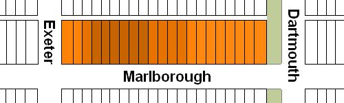
The block on the north side of Marlborough between Dartmouth and Exeter is 528 feet in length and 112 feet from Marlborough to Alley 418.
The land was part of the approximately 108 acres of land in the Back Bay owned by the Commonwealth of Massachusetts.
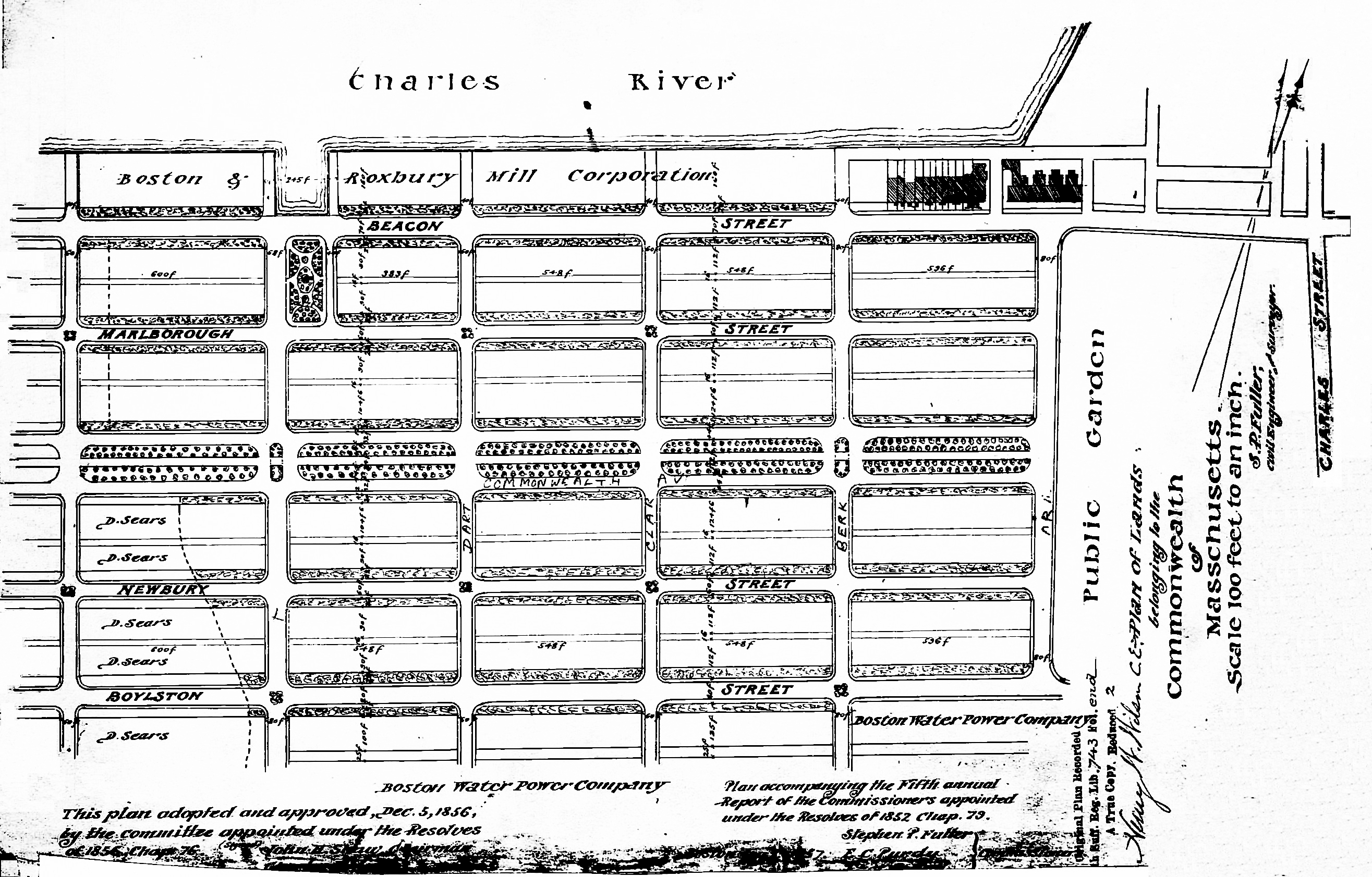
Plan of Commonwealth lands, 5Dec1856 (Suffolk Co. Deed Registry, Book 743, end of book)
The Commonwealth sold its land starting in 1857. The earliest transactions were by private sales negotiated by the Commissioners on the Back Bay. In 1860, the legislature required that all future sales be made through public auctions. The first auction was held on October 24, 1860, and they continued until March of 1872, when they were suspended due to depressed real estate values. In 1879, the legislature authorized the Harbor and Land Commissioners (successors to the Commissioners on the Back Bay) to sell lots with frontages of up to 100 feet by privately negotiated sale. The land sales resumed in May of 1879 and the last of the remaining land was sold in 1886.
Click here for more information on the Commonwealth of Massachusetts land in the Back Bay.
The land on the north side of Marlborough between Dartmouth and Exeter was sold by the Commonwealth at several auctions between 1866 and 1869 in twenty-one lots: a 30 foot lot at the corner of Dartmouth (Lot 1), twelve 25 foot lots to the west of the corner lot (Lots 2-13), seven 24 foot lots to the west of those (lots 14-20), and a 30 foot lot at the corner of Exeter (Lot 21).
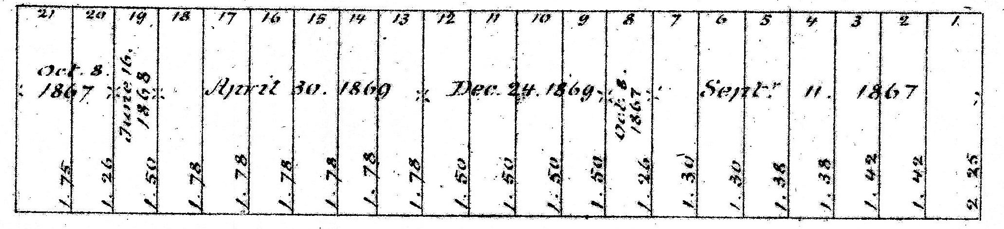
Excerpt from plan of land sales through 1879, showing price paid per s.f.; 1879 Harbor and Land Commissioners Report
The Commonwealth offered the seven lots on the eastern end of the block (Lots 1-7) at its auction on September 11, 1866 (erroneously shown as 1867 on the Harbor and Land Commissioner’s 1879 map). The Boston Journal reported on September 12, 1866, that the 30 foot corner lot at Dartmouth had been purchased by Norman Carmine Munson, the Commonwealth’s contractor for filling its land. The next four lots (Lots 2-5) were purchased by banker William Thomas, and the two west of them (Lots 6-7) by James Eaton. William Thomas and his wife, Cornelia Jane (Bangs) Thomas, lived at 10 Marlborough, and James Eaton and his wife, Elizabeth Webster (Kittredge) Eaton, lived at 332 Beacon.
The remaining fourteen lots were offered for sale sold at the Commonwealth’s October 8, 1867, auction. The October 9, 1867, Boston Herald reported that there were successful bids for seven of the lots. However, four of the bids apparently were not honored and only three lots were registered as being sold: the eastern-most 25 foot lot (Lot 8), the 30 foot lot at the corner of Exeter (Lot 21), and the 24 foot lot next to it (Lot 20). All three were purchased by retired dry goods merchant Peter Thacher Homer. He and his wife, Caroline (Bunker) Homer, lived at 27 Mt. Vernon.
The Commonwealth offered the unsold eleven lots at its June 16, 1868, auction, but only the 24 foot lot furthest west (Lot 19) sold. The Boston Traveller for June 16, 1868, reported that the buyer was wholesale grocer Daniel Goodnow, who lived at 33 Upton.
At the December 24, 1868, auction, the remaining ten lots were offered, but only the eastern-most 25 foot lots (Lots 9-12) were sold. The Boston Traveller of that date reported the buyer was attorney Hales W. Suter, who lived at 11 Union Park.
The last six lots on the block (Lots 13-18) were sold at the Commonwealth’s April 30, 1869, auction, with Boston Traveller reporting that the successful bidder for all six was investment banker Henry C. Wainwright. He and his wife, Sarah Blake (Dexter) Wainwright, lived at 413 Beacon.
Eastern Parcels. On November 2, 1869, the Commonwealth sold William Thomas a parcel with a 100 foot frontage on Marlborough, comprising the four 25 foot lots (Lots 2-5) for which he had been the successful bidder at the September 11, 1866, auction. He sold the parcel on March 9, 1870, to dry goods merchant Eben Dyer Jordan, co-founder of Jordan, Marsh & Co.
On November 29, 1870, the Commonwealth sold building contractor George Wheatland, Jr., the corner lot at Dartmouth (Norman C. Munson, the successful bidder, having sold or transfer his deed bond for the land). On December 3, 1870, George Wheatland purchased the eastern 70 feet of Eben Jordan’s land. He combined the land with his corner lot, and sold a lot with a 100 foot frontage on Marlborough and 57 foot frontage on Dartmouth to Thomas Forbes Cushing that same day. He retained the remaining lot, with a 55 foot frontage on Dartmouth and a 100 foot frontage on the alley.
Thomas Cushing built 163 Marlborough as his home and George Wheatland, Jr., built 326-328 Dartmouth for speculative sale. The houses were built with an irregular east-west boundary and, as built, did not conform with the original lots. Accordingly, on December 29, 1871, and January 16, 1872, Thomas Cushing and George Wheatland, Jr., exchanged parcels of land to reflect the irregular shape, with 163 Marlborough having a 44 foot frontage on Dartmouth and 326-328 Dartmouth having a 68 foot frontage.
On May 1, 1871, Eben Jordan sold the remaining 30 feet of his land to investment banker Henry Lee, Jr, who had purchased the two lots further west (Lots 6-7) from the Commonwealth several days earlier, on April 25, 1871 (Lots 6-7 had been purchased at the September 11, 1866, auction by James Eaton, who subsequently sold or transferred his rights to purchase them).
On June 15, 1878, Henry Lee, Jr., sold the eastern 54 feet of his land, a 27 foot lot to Mary A. (Upham) Gordon, the widow of Dr. Charles Gordon, who built her home at 167 Marlborough (there is no 165 Marlborough), and a 27 foot lot to Hannah (Buck) Shaw, the widow of Samuel Parkman Shaw, who built her home at 169 Marlborough.
On April 11, 1881, Henry Lee, Jr., sold the western 26 feet of his land to Geraldine Ipolite (Russell) Rivers Upton, the wife of George Bruce Upton, Jr. That same day, George Upton, Jr., purchased the 25 foot lot to the west from Peter T. Homer (Lot 8), who had been the successful bidder for it at the October 8, 1867, auction and had purchased it from the Commonwealth on April 5, 1881 (presumably in anticipation of selling it several days later to George Upton, Jr.). The Uptons built 171-173 Marlborough; they kept 171 Marlborough as their home and sold 173 Marlborough to George S. Cushing.
Central Parcels. On June 13, 1871, June 22, 1871, and August 31, 1871, the Commonwealth sold building contractor Silas Whiton Merrill the four 25 foot lots (Lots 9-12) to the west of where 173 Marlborough would be built. Hales W. Suter had been the successful bidder at the December 24, 1868 auction, and had sold or transferred his rights to purchase tham.
Silas Merrill built 175-177 Marlborough on the eastern two lots, for speculative sale. He sold the western 50 feet on April 25, 1872, to T. Jefferson Coolidge. On November 27, 1880, T. Jefferson Coolidge sold the parcel to John Quincy Adams, who subdivided it into a 24 foot lot to the east and a 26 foot lot to the west. He sold the 26 foot lot on February 4, 1881, to John Larkin Thorndike, who built his home at 181 Marlborough, and sold the 24 foot lot on February 7, 1881, to George Bruce Upton, Jr., who sold it on April 4, 1881, to Horatio Greenough Curtis, who built his home at 179 Marlborough.
On May 31, 1872, shortly after he acquired Silas Merrill’s two lots, T. Jefferson Coolidge joined with James Lawrence to purchase the six lots to the west (Lots 13-18, one 25 foot lot and five 24 foot lots) for which Henry C. Wainwright had been the successful bidder at the April 30, 1869, auction. Earlier that month, they had purchased four lots on the south side of Marlborough for which Henry Wainwright also had been the successful bidder at the same auction.
Thomas Jefferson Coolidge was an investor in textile mills, banks, and railroads. In 1890, he joined his son, T. Jefferson Coolidge, Jr., in founding the Old Colony Trust Company. He served as Ambassador to France in 1892 and 1893. He and his wife, Mehitable (Hetty) Sullivan (Appleton) Coolidge, lived at 93 Beacon. She died in March of 1901 and he subsequently lived at 315 Dartmouth.
James Lawrence was a dry goods merchant in his family’s firm, A. & A. Lawrence & Co. He and his wife, Anna Lothrop (Motley) Lawrence, lived at 38 Beacon and in Groton.
In December of 1872, T. Jefferson Coolidge transferred his interest in the eastern three lots (Lots 13-15), with a frontage of 73 feet, to James Lawrence, and James Lawrence transferred his interest in the western three lots (Lots 16-18), with a frontage of 72 feet, to T. Jefferson Coolidge. That same month, they also exchanged their interests in the four lots on the south side of Marlborough so that each held two of the four lots.
James Lawrence died in February of 1875 and on May 2, 1882, his daughter, Gertrude (Lawrence) Peabody, the wife of John Endicott Peabody, acquired her siblings’ interests in the eastern 32 feet of her late father’s land. She and her husband built 183 Marlborough as their home.
On November 23, 1883, Edward Sturgis Grew purchased a 32 foot lot from James Lawrence’s heirs next to the Peabodys’ lot. He built 185 Marlborough on the eastern 30 feet.
There remained vacant the western two feet of the lot owned by Edward Grew and an additional 9 feet west of that, which was the remainder of James Lawrence’s land.
Western Parcels. In their fifth annual report, the Commissioners on the Back Bay published a map of the Commonwealth’s lands. The map was recorded at the end of Suffolk County Deed Registry Book 743 and again, in a slightly modified form, in Book 788, p. 160, and was referenced in subsequent deeds issued by the Commonwealth.
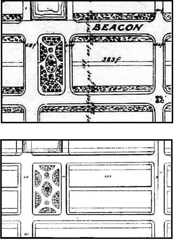
Detail from plan of Commonwealth lands, 5Dec1856 as recorded in Suffolk Co. Deed Registry, Book 743, end of book, and again in Book 788, p. 160)
The 1856 map included a public park at the western end of the block between Dartmouth and Exeter, running between the south side of Beacon and the north side of Marlborough, with a frontage of 137 feet plus a 4 foot wide passageway. The Commonwealth subsequently eliminated the park and sold the land as Lots 17 through 21 and part of Lot 16 on Beacon and on Marlborough. The Commonwealth’s deeds, however, continued to reference the earlier map, potentially creating confusion as to whether other land holders or the public might hold an easement over the land.
To eliminate any uncertainty, in 1880, T. Jefferson Coolidge entered into an agreement to sell some or all of his land (Lots 16-18) to attorney William Sohier Dexter. They then filed suit in equity, with T. Jefferson Coolidge as plaintiff and William Dexter as defendant, to clarify the issue. As reported by the Boston Globe on July 9, 1880, the court ruled that “the reference to the plan was not sufficiently definite to be binding upon the commonwealth in such a manner as to create a cloud upon the title.” William Sohier did not subsequently purchase the land (the agreement probably having been solely for the purpose of creating legal standing in the suit).
On November 27, 1880, T. Jefferson Coolidge sold his 72 foot parcel (Lots 16-18) to John Quincy Adams.
On November 27, 1880, T. Jefferson Coolidge sold his 72 foot parcel (Lots 16-18) to the west of James Lawrence’s land to John Quincy Adams.
On February 7, 1881, John Quincy Adams sold the western 16 feet of his land to George Bruce Upton, Jr. On May 10, 1881, John Quincy Adams acquired the 9 feet to the east from James Lawrence’s heirs, and on September 9, 1881, he sold the 9 feet to George B. Upton, Jr., increasing his lot to 25 feet. Ten days later, on September 19, 1881, George B. Upton, Jr., sold the 25 foot lot to Charles William Galloupe, and on January 28, 1884, Edward Grew sold the vacant two foot strip west of his land to Charles Galloupe, increasing his land to 27 feet.
Charles Galloupe left his land vacant. He died in November of 1903 and it was inherited by his daughter, Wilhelmina (Galloupe) Mixter, the wife of Samuel Jason Mixter. She sold the lot on December 13, 1905, to Henrietta Goddard (Wigglesworth) Porter, the wife of Alexander Sylvanus Porter, and they built their home at 189 Marlborough (there is no 187 Marlborough).
On February 17, 1881, John Quincy Adams sold a 32 foot lot to the west of the land he had sold George B. Upton, Jr., to Edmund Dwight, who build his home at 191 Marlborough.
On November 21, 1882, John Quincy Adams sold the remaining 24 feet of his land (Lot 18) to Harvard law professor James Barr Ames, His father, building contractor Samuel Tarbell Ames, built 193 Marlborough for speculative sale.
Lot 21, the 30 foot lot at the corner of Exeter, and Lot 20, the 24 foot lot east of it, had been purchased by Peter T. Homer at the October 9, 1867, auction, and Lot 19, the 24 foot lot next to the east, had been purchased at the June 16, 1868, auction, by Daniel Goodnow.
On June 15, 1871, Daniel Goodnow took title to Lot 19 from the Commonwealth. On September 23, 1880, he sold it to Mary Coffin (Lunt) Shepard, the wife of attorney Edward Orcott Shepard and, on December 18, 1882, she sold it to Alice (Daland) Chandler, the wife of Francis Ward Chandler. The Chandlers built their home at 195 Marlborough.
Peter Homer subsequently sold or transferred his rights to purchase his two lots at the corner of Exeter, and on June 25, 1888, they were purchased from the Commonwealth by paper manufacturer and former attorney Samuel Dennis Warren, Jr.
Samuel D, Warren, Jr., sold the 30 foot corner lot on October 20, 1890, to real estate dealer Seth Russell Baker, who built a six-unit apartment house at 199 Marlborough. He sold the 24 foot lot (Lot 20) on April 16, 1891, to real estate investor George H. Brooks, who had built the Hotel Royal apartments across the alley at 295-297 Beacon, several years earlier. He sold the lot two months later, on June 2, 1891, to Harriet J. (White) Bradbury, wife of Frederick T. Bradbury. The Bradburys built their home at 197 Marlborough.
Original Construction. With the exception of 189 Marlborough, which remained a vacant lot until 1906, all of the buildings on the north side of Marlborough between Dartmouth and Exeter had been built by 1891.
The plans below illustrate when the land on the block was first sold at auction by the Commonwealth, when the Commonwealth conveyed the land (based on the dates of the deeds), and when houses were first constructed (based on building permit applications, news reports, and dates provided in Bainbridge Bunting’s Houses of Boston’s Back Bay).
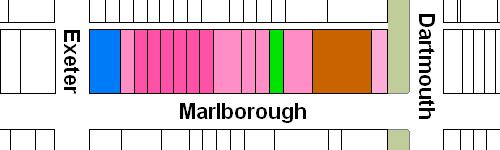
Original land sales on the north side of Marlborough between Dartmouth and Exeter
Original deeds conveying land on the north side of Marlborough between Dartmouth and Exeter
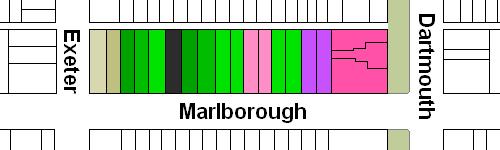
Original construction on the north side of Marlborough between Dartmouth and Exeter
Building Restrictions in Original Land Deeds
The deeds from the Commonwealth included identical language specifying that any building on the land was to be “at least three stories high for the main part thereof and shall not in any event be used for a stable, or for any mechanical or manufacturing purposes;” that the front walls were to be set back twenty-two feet from Marlborough, with “steps, windows, porticos, and other usual projections appurtenant thereto” allowed in the reserved space subject to dimensional limitations enumerated in the deed; and that “no cellar or lower floor of any building shall be placed more than four feet below the level of the mill-dam, as fixed by the top surface of the hammered stone at the south-easterly corner of the emptying sluices.” The deed also provided that the owners of the land would have the right to “cultivate trees on the side walks” in front of their land provided that they left a distance of ten feet between the front boundary of their lots and the trees.
In November of 1858, the Commissioners on the Back Bay had voted to clarify that the prohibition on stables would not be enforced “in such a manner as to prevent the erection and use of private stables by gentlemen as appurtenances to their own dwelling homes; provided, such stables are so constructed and used as not to be justly offensive to the occupants of the surrounding buildings.” This clarification was subsequently published in the auction catalogues issued by the Commissioners, but usually was not included in the deeds.
Click here for more information on the restrictions contained in deeds of Back Bay land.
Original Land Deeds
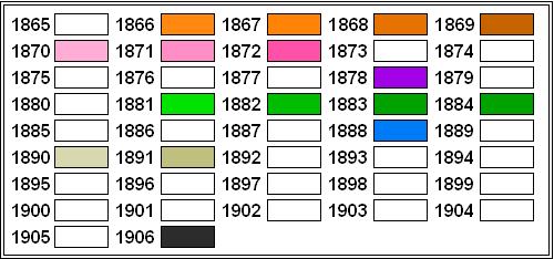
The Commonwealth of Massachusetts conveyed the land on the north side of Marlborough between Dartmouth and Exeter by the following deeds:
| Address | Date | E-W | N-S | Grantee | Book | Page |
| 163-169 Marlborough
326-328 Dartmouth |
29Nov1870 | 30’ | 112’ | George Wheatland, Jr. | 1026 | 44 |
| 163-169 Marlborough
326-328 Dartmouth |
02Nov1869 | 100’ | 112’ | William Thomas | 982 | 159 |
| 169 Marlborough | 25Apr1871 | 50’ | 112’ | Henry Lee | 1054 | 34 |
| 169-173 Marlborough | 05Apr1881 | 25’ | 112’ | Peter T. Homer | 1520 | 358 |
| 175 Marlborough | 22Jun1871 | 25’ | 112’ | Silas W. Merrill | 1058 | 33 |
| 177 Marlborough | 31Aug1871 | 25’ | 112’ | Silas W. Merrill | 1068 | 265 |
| 179-181 Marlborough | 13Jun1871 | 50’ | 112’ | Silas W. Merrill | 1055 | 27 |
| 183 Marlborough | 31May1872 | 25’ | 112’ | T. Jefferson Coolidge and James Lawrence | 1133 | 34 |
| 183-185 Marlborough | 31May1872 | 24’ | 112’ | T. Jefferson Coolidge and James Lawrence | 1133 | 36 |
| 185-189 Marlborough | 31May1872 | 24’ | 112’ | T. Jefferson Coolidge and James Lawrence | 1133 | 37 |
| 189-191 Marlborough | 31May1872 | 24’ | 112’ | T. Jefferson Coolidge and James Lawrence | 1133 | 39 |
| 191-193 Marlborough | 31May1872 | 24’ | 112’ | T. Jefferson Coolidge and James Lawrence | 1133 | 41 |
| 193 Marlborough | 31May1872 | 24’ | 112’ | T. Jefferson Coolidge and James Lawrence | 1133 | 42 |
| 195 Marlborough | 15Jun1871 | 24’ | 112’ | Daniel Goodnow | 1055 | 37 |
| 197-199 Marlborough | 25Jun1888 | 54’ | 112’ | Samuel D. Warren | 1829 | 153 |
