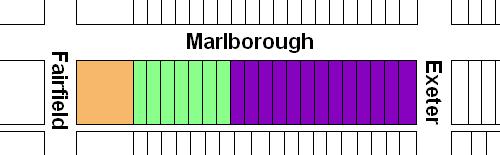
The block on the south side of Marlborough between Exeter and Fairfield is 600 feet in length and 112 feet from Marlborough to Alley 426.
The eastern 504.8 feet of the block were part of the approximately 108 acres of land owned by the Commonwealth of Massachusetts. The western 95.2 feet were part of the lands owned by the Boston Water Power Company, which included all of the land from the south side of Beacon to the north side of Commonwealth west of the Commonwealth’s lands.
There was a 0.37 foot (4½ inch) discrepancy in the original deeds from the Commonwealth and the Boston Water Power Company, with the Commonwealth deeds placing the boundary at 95.20 feet from Fairfield and the Boston Water Power Company deeds placing it at 95.57 feet from the corner. Click here for more detail.
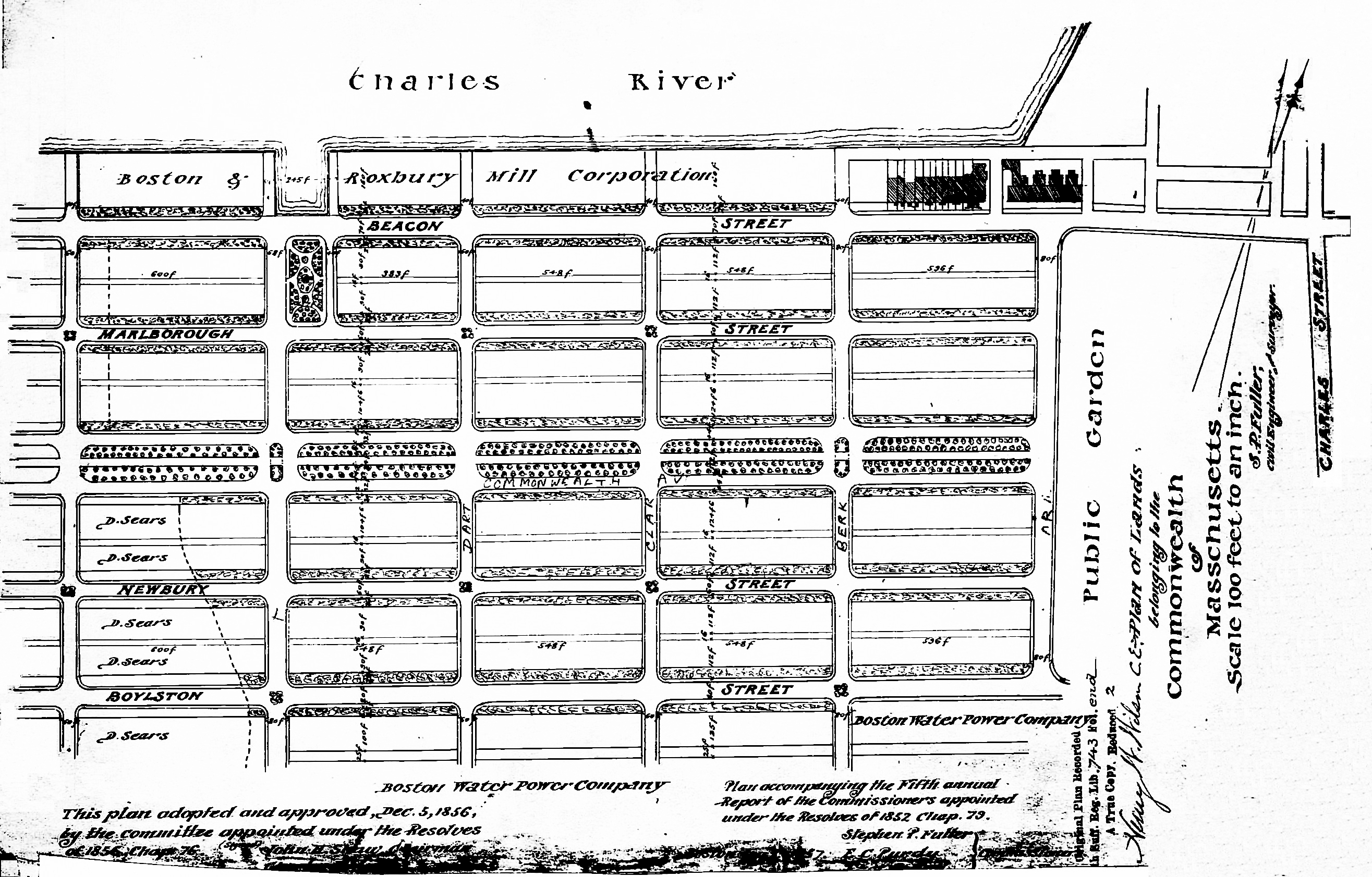
Plan of Commonwealth lands, 5Dec1856 (Suffolk Co. Deed Registry, Book 743, end of book)
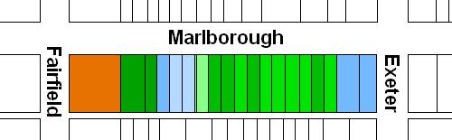
Commonwealth of Massachusetts Land. The Commonwealth sold its land starting in 1857. The earliest transactions were by private sales negotiated by the Commissioners on the Back Bay. In 1860, the legislature required that all future sales be made through public auctions. The first auction was held on October 24, 1860, and they continued until March of 1872, when they were suspended due to depressed real estate values. In 1879, the legislature authorized the Harbor and Land Commissioners (successors to the Commissioners on the Back Bay) to sell lots with frontages of up to 100 feet by privately negotiated sale. The land sales resumed in May of 1879 and the last of the remaining land was sold in 1886.
Click here for more information on the Commonwealth of Massachusetts land in the Back Bay.
The Commonwealth sold its land on the south side of Marlborough between Exeter and Fairfield through privately-negotiated sales in 1879 and 1880.
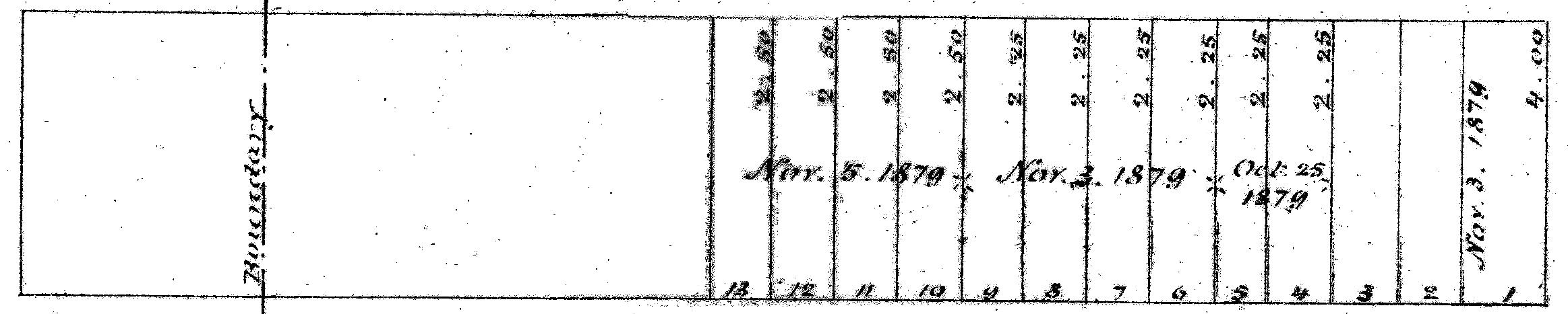
Excerpt from plan of land sales through 1879, showing price paid per s.f.; 1879 Harbor and Land Commissioners Report
A plan accompanying the 1879 Harbor and Land Commissioners Report showing all of the land sales through 1879 indicated that eleven lots were sold through privately-negotiated sales in 1879: Lots 4-5 were sold on October 25, 1879; the lot at the corner of Exeter (Lot 1) and fourlots further west (Lots 6-9) were sold on November 3, 1879; and four lots to the west of them (Lots 10-13) were sold on November 5, 1879. The two lots immediately to the west of the corner (Lots 2-3) were not sold in 1879. Neither the map nor the report identifies the names of the purchasers nor the size of the lots, and there does not appear to have been a news account of their sale. Several of the purchasers can be identified, however, from subsequent deeds.
In their annual report for 1880, the Harbor and Land Commissioners reported that all of the remaining land on the south side of Marlborough had been sold during that year. Again, the names of the purchasers were not given nor do they appear to have been reported in the press, but can be inferred from subsequent deeds.
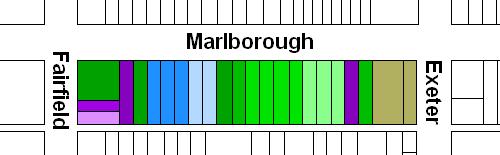
Boston Water Power Company Lands. The Boston Water Power Company sold its land in large parcels, almost exclusively to real estate investment trusts which then subdivided the land and resold it. It sold land in 1863, 1866, 1868, and 1872, by which point it had sold all of its land between the Commonwealth’s lands and a line 125 feet west of Massachusetts Avenue (West Chester Park). It sold the remainder of its land in the residential portion of the neighborhood in 1880.
Detail from plan by J. F. Fuller, showing land purchased by Daniel Davies et al (Fairfield shown as “6th Street”); Suffolk Co. Deed Registry, Book 826, p. 87; 25Feb1863
Click here for more information on the Boston Water Power Company land in the Back Bay.
On February 16, 1863, the Boston Water Power Company sold all of its land from the boundary with the Commonwealth to Fairfield on the south side of Beacon, north and south side of Marlborough, and north side of Commonwealth, to Daniel Davies, Jarvis D. Braman, and Grenville T. W. Braman.
Grenville Temple Winthrop Braman was a real estate investor and treasurer of the Boston Water Power Company, remaining in that position until mid-1869. Jarvis Dwight Braman was his brother. In the mid-1860s he was assistant paymaster for the Commonwealth, and by the 1870s he was engaged in real estate with his brother. In mid- to late-1878, he became President of the Boston Water Power Company, remaining in that position until his death in October of 1888. Daniel Davies was a housewright and master carpenter. His daughter, Susan (Susie) A. (Davies) Braman, was Grenville Braman’s wife.
Eastern Parcels. On January 12, 1886, the Commonwealth sold the corner lot at Exeter, with a frontage of 32 feet, and a 51.5 foot lot to the west of it to investment banker Henry Lee, Jr. The lot subsequently changed hands and on February 28, 1892, was purchased by real estate dealer Albert Geiger. On March 26, 1882, he purchased a six inch strip of land to the west, with the eastern half of the party wall with 226 Marlborough on it. He subsequently built two apartment buildings, 220 Marlborough and 222-224 Marlborough, on the lot.
On October 25, 1879, the Commonwealth had entered into contracts to sell the two lots to the west, a 26.5 foot lot to Dr. Clarence John Blake and a 20.5 foot lot to Dr. William Fiske Whitney, Jr.
Clarence Blake purchased and took title to his land on September 29, 1881, and built his home at 226 Marlborough. He built the eastern wall entirely on his land (rather than having it straddle the boundary between his land the land to the east, as was customary). As noted above, he sold the eastern six inches, with the party wall on it, to Albert Geiger in March of 1882.
William Whitney, Jr., built his home at 228 Marlborough in 1879-1880, and purchased and took title to the land on July 10, 1882, after the house had been completed.
Central Parcels. The nine 25 foot lots to the west of 228 Marlborough were sold by the Commonwealth of Massachusetts through privately-negotiated agreements in November of 1879 and in early1880. Based on subsequent deeds and permits, it appears likely that the contracts for the eastern four lots, entered into on November 3, 1879, and for the next four lots to the west, entered into on November 5, 1880, were with the real estate dealers (and brothers) Frederick Augustus Whitwell, Henry Whitewell, and Samuel Horatio Whitwell. The ninth lot was purchased from the Commonwealth on February 16, 1880, by George E. Niles, who sold it to Samuel H. Whitwell on March 23, 1883, who supplemented it with an additional one foot lot to the west, purchased from the Commonwealth on January 15, 1884.
The Whitwells built 230-232-234-236-238-240-242-244-246 Marlborough on the nine lots, all designed in a similar style. The Whitwells appear to have retained architect Samuel D. Kelley to prepare a common design for the houses and building contractor Samuel T. Ames to oversee their construction, transferring to him their right to purchase the lots at 232-234-236 Marlborough as compensation. In most cases, when the houses were nearing completion, they were sold to individual buyers who purchased the land directly from the Commonwealth and paid the Whitwells or Samuel T. Ames for the cost of the dwelling house. Frederick Whitwell kept 230 Marlborough, the first house built, as his home. Samuel H. Whitwell kept 244-246 Marlborough, buying the land and then reselling the land and houses to individual buyers.
There is an unresolved discrepancy in the land deeds relating to 228 Marlborough and 230 Marlborough.
On March 15, 1880, the Commonwealth conveyed to Samuel H. Whitwell a strip of land beginning at a line 130 feet west of Exeter and running west 6 inches to a line 130.5 feet west of Exeter. On March 25, 1880, Samuel Whitwell sold this strip of land to Frederick A. Whitwell, and on April 2, 1881, the Commonwealth conveyed to Frederick A. Whitwell a lot beginning at a line 130.5 feet west of Exeter and running west 24.5 feet to a line 155 feet west of Exeter. All subsequent deeds for 230 Marlborough have stated that the northern and southern boundaries are 25 feet (the 6 inches conveyed by the Commonwealth to Samuel H. Whitwell and by him to Frederick A. Whitwell, and the 24.5 feet conveyed by the Commonwealth to Frederick A. Whitwell).
However, on July 10, 1882, the Commonwealth of Massachusetts conveyed to William F. Whitney a lot beginning at a line 110 feet west of Exeter and running west 20.5 feet to a line 130.5 feet west of Exeter. All subsequent deeds for 228 Marlborough have stated that the northern and southern boundaries are 20.5 feet.
The six inches running from 130 feet to 130.5 feet west of Exeter therefore is included in the lots for both 228 Marlborough and 230 Marlborough.
On January 9, 1885, the Commonwealth sold to Henry Whitwell the two 25 foot lots to the west of 246 Marlborough. He sold the lot to the east on January 17, 1885, to Dr. Wilbur Bates Parker, who built his home at 248 Marlborough with a separate entrance, numbered 250 Marlborough, for his dental office. Henry Whitwell sold the lot to the west on September 1, 1885, to Ellen M. Barr, who built her home at 252 Marlborough.
On June 9, 1886, the Commonwealth sold the 24.5 foot lot to the west of 252 Marlborough to building contractor Silas Whiton Merrill. That same month, he also acquired the 25 foot lot to the west from George Bruce Upton and the 24 foot lot west of that from Nelson Slater Bartlett. Silas Merrill reconfigured the lots and built 254 Marlborough and 256 Marlborough on 24 foot lots and 258 Marlborough on a 25.5 foot lot, all three for speculative sale.
George B. Upton had purchased his lot on March 30, 1886, from Richard M. Hodges, who had purchased it from the Commonwealth on February 9, 1884. Nelson S. Bartlett had acquired his lot on June 15, 1886 (the same day he sold it to Silas Merrill) from his mother, Mary Eliza (Meads) Bartlett, the widow of Matthew Bartlett. It was the eastern 24 feet of a 50 foot lot she had purchased from the Commonwealth on October 30, 1884. Nelson Bartlett and his wife, Isabel (Bullock) Barlett, built their home at 272 Marlborough, on the eastern 26 feet of the land purchased from the Commonwealth by his mother (there are no houses numbered 260-262-264-266-268-270 Marlborough).
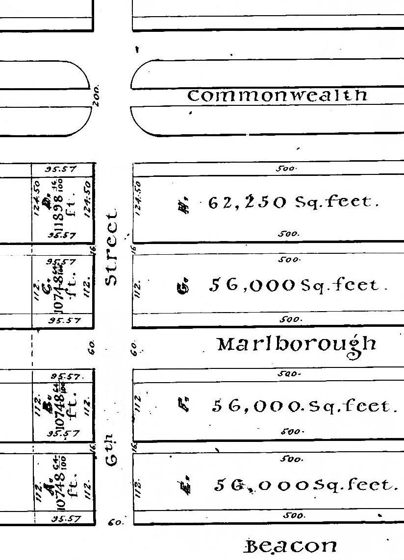
Western Parcels. On February 16, 1863, the Boston Water Power Company sold all of its land on the south side of Marlborough between Exeter and Fairfield to Daniel Davies, Jarvis D. Braman, and Grenville T. W. Braman. The deed indicated that the parcel extended west 95.57 feet from the boundary with the lands owned by the Commonwealth to Fairfield. As noted above, this description was inconsistent with the Commonwealth’s deeds, which placed the boundary 95.20 feet east of Fairfield. Click here for more details.
On December 30, 1868, Daniel Davies and his partners sold their parcels on the south side of Marlborough and the north side of Commonwealth to Henry N. F. Marshall, a dealer in paints, oils, and glass. On February 25, 1869, he sold both parcels to James C. White, and on June 29, 1869, James White sold both parcels to Dr. Horatio Robinson Storer, a physician.
On October 1, 1872, merchant and real estate investor Franklin Evans purchased the parcel on the south side of Marlborough from Horatio Storer.
Franklin Evans died in January in 1874. On June 11, 1875, his widow, Carrie (Ellis) Evans, sold lot at the corner of Fairfield and the alley, with a frontage on Fairfield of 20 feet and a depth of 71.57 feet, to Francis Richmond Allen. He and his wife, Elizabeth Bradlee (Wood) Allen, built their home at 20 Fairfield.

Plan by Henry W. Wilson, 1Jan1876 (Suffolk Co. Deed Registry, Book 1321, p. 76)
Franklin Evans had an agreement with Charles U. Cotting of Brookline that they would share equally in the profits and losses from their land investments, and on January 12, 1876, the Norfolk County Probate Court approved an agreement under which Franklin Evans’s holdings were divided between Charles Cotting and Carrie Evans.
Under the agreement, the parcel at the western end of Marlborough was subdivided into five lots: one lot on the eastern end of the parcel with a 24 foot frontage on Fairfield, and four lots facing Fairfield with a depth of 71.57 feet (Lots 2-5), including the lot sold to Francis Allen. Carrie Evans retained the proceeds from the sale of the lot to Francis Allen (Lot 5) and received the lot north of it (Lot 4) with a 19 foot frontage on Fairfield and the lot with a 24 foot frontage on Marlborough (Lot 1). Charles Cotting received the remaining lots facing Fairfield (Lots 2 and 3), with a combined frontage of 69 feet. He transferred the property to his wife, Susan Cordelia (Delano) Cotting on April 21, 1877.
On April 15, 1878, Carrie Evans sold the 19 foot lot on Fairfield to Elizabeth Tucker (Washburn) Grinnell, the wife of Charles Edward Grinnell. The Grinnells built their home at 18 Fairfield.
On May 21, 1879, Carrie Evans sold the lot on Marlborough to a trust established by Charles Greenleaf Wood, Jr., to manage his property. He built his home at 274 Marlborough.
On February 3, 1880, Susan Cotting sold the corner lot, with a frontage of 69 feet on Fairfield, to real estate dealer Samuel H. Whitwell, and on June 4, 1883, he sold the land to Fanny Pope (Hovey) Morse, the wife of John Torrey Morse, Jr. The Morses built their home at 16 Fairfield (276 Marlborough).
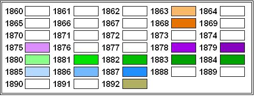
Original Construction. All of the buildings on the south side of Marlborough between Exeter and Fairfield had been built by 1892.
The plans below illustrate when the land on the block was first sold by the Commonwealth or the Boston Water Power Company, when the Commonwealth or Boston Water Power Company conveyed the land (based on the dates of the deeds), and when houses were first constructed (based on building permit applications, news reports, and dates provided in Bainbridge Bunting’s Houses of Boston’s Back Bay).
Original land sales on the south side of Marlborough between Exeter and Fairfield
Original deeds conveying land on the south side of Marlborough between Exeter and Fairfield
Original construction on the south side of Marlborough between Exeter and Fairfield
Building Restrictions in Original Land Deeds
The deeds from the Commonwealth included identical language specifying that any building on the land was to be “at least three stories high for the main part thereof and shall not in any event be used for a stable, or for any mechanical or manufacturing purposes;” that the front walls were to be set back twenty-two feet from Marlborough, with “steps, windows, porticos, and other usual projections appurtenant thereto” allowed in the reserved space subject to dimensional limitations enumerated in the deed; and that “no cellar or lower floor of any building shall be placed more than four feet below the level of the mill-dam, as fixed by the top surface of the hammered stone at the south-easterly corner of the emptying sluices.” The deed also provided that the owners of the land would have the right to “cultivate trees on the side walks” in front of their land provided that they left a distance of ten feet between the front boundary of their lots and the trees.
In November of 1858, the Commissioners on the Back Bay had voted to clarify that the prohibition on stables would not be enforced “in such a manner as to prevent the erection and use of private stables by gentlemen as appurtenances to their own dwelling homes; provided, such stables are so constructed and used as not to be justly offensive to the occupants of the surrounding buildings.” This clarification was subsequently published in the auction catalogues issued by the Commissioners, but usually was not included in the deeds.
The February 16, 1863, deed from the Boston Water Power Company to Daniel Davies and his partners included language almost identical to that of the Commonwealth’s deeds, with the exception that the height of the buildings was required to be “at least two stories high for the main part thereof exclusive of basement and attic” and the prohibition against stables was clarified as being a prohibition against “livery stables.”
Click here for more information on the restrictions contained in deeds of Back Bay land.
Original Land Deeds
The Commonwealth of Massachusetts conveyed the land on the south side of Marlborough between Exeter and Fairfield by the following deeds:
| Address | Date | E-W | N-S | Grantee | Book | Page |
| 220-224 Marlborough | 12Jan1886 | 32’ | 112’ | Henry Lee | 1709 | 100 |
| 220-224 Marlborough | 12Jan1886 | 51.5’ | 112’ | Henry Lee | 1709 | 97 |
| 220-226 Marlborough | 29Sep1881 | 26.5’ | 112’ | Clarence J. Blake | 1543 | 121 |
| 228 Marlborough | 10Jul1882 | 20.5’ | 112’ | William F. Whitney | 1567 | 33 |
| 230 Marlborough | 15Mar1880
(recorded 9Apr1881) |
0.5’ | 112’ | Samuel H. Whitwell | 1520 | 242 |
| 230 Marlborough | 02Apr1881 (recorded 9Apr1881) | 24.5’ | 112’ | Frederick A. Whitwell | 1520 | 246 |
| 232 Marlborough | 28Mar1881 | 25’ | 112’ | Abba M. Cumings, wife of John W. Cumings | 1538 | 316 |
| 234 Marlborough | 30Mar1881 | 25’ | 112’ | Elizabeth K. Hervey, wife of Abraham F. Hervey | 1519 | 513 |
| 236 Marlborough | 03Nov1881 | 25’ | 112’ | Emily T. Osborn, wife of Francis A. Osborn | 1543 | 273 |
| 238 Marlborough | 10Aug1882 | 25’ | 112’ | John Parkinson | 1570 | 164 |
| 240 Marlborough | 29Sep1881 | 25’ | 112’ | Nathaniel D. Silsbee, William E. Silsbee, and Frederick A. Whitwell, trustees under the will of Nathaniel Silsbee | 1543 | 252 |
| 242 Marlborough | 31Jul1882 | 25’ | 112’ | Mary E. Meredith, wife of Joseph H. Meredith | 1569 | 106 |
| 244 Marlborough | 13Nov1882 | 25’ | 112’ | Samuel H. Whitwell | 1579 | 471 |
| 246 Marlborough | 16Feb1880 | 24.3’ | 112’ | George E. Niles | 1591 | 321 |
| 246 Marlborough | 15Jan1884 | 1’ | 112’ | S. Horatio Whitwelkl | 1625 | 371 |
| 248 Marlborough | 09Jan1885 | 25’ | 112’ | Henry Whitwell | 1665 | 17 |
| 252 Marlborough | 09Jan1885 | 25’ | 112’ | Henry Whitwell | 1665 | 20 |
| 254 Marlborough | 09Jun1886 | 24.5’ | 112’ | Silas W. Merrill | 1727 | 289 |
| 254-258 Marlborough | 09Feb1884 | 25’ | 112’ | Richard M. Hodges | 1630 | 145 |
| 258-272 Marlborough | 30Oct1884 | 50’ | 112’ | Mary E. Bartlett | 1658 | 534 |
The Boston Water Power Company conveyed the land on the south side of Marlborough between Exeter and Fairfield by the following deed:
| Address | Date | E-W | N-S | Grantee | Book | Page |
| 274 Marlborough 16-20 Fairfield |
16Feb1863 | 95.57’ | 112’ | Daniel Davies, Jarvis D. Braman, and Grenville T. W. Braman | 826 | 86 |
Daniel Davies, Jarvis Braman, and Grenville T. W. Braman conveyed the land on the south side of Marlborough between Exeter and Fairfield by the following deed:
| Address | Date | E-W | N-S | Grantee | Book | Page |
| 274 Marlborough 16-20 Fairfield |
30Dec1868 | 95.57’ | 112’ | Henry N. F. Marshall | 948 | 185 |
