The block on the north side of Commonwealth between Exeter and Fairfield is 600 feet in length and 124 feet 6 inches from Commonwealth to Alley 426.
The eastern 504.8 feet of the block were part of the approximately 108 acres of land owned by the Commonwealth of Massachusetts. The western 95.2 feet were part of the lands owned by the Boston Water Power Company, which included all of the land from the south side of Beacon to the north side of Commonwealth west of the Commonwealth’s lands.
There was a 0.37 foot (4½ inch) discrepancy in the original deeds from the Commonwealth and the Boston Water Power Company, with the Commonwealth deeds placing the boundary at 95.20 feet from Fairfield and the Boston Water Power Company deeds placing it at 95.57 feet from the corner. Click here for more detail.
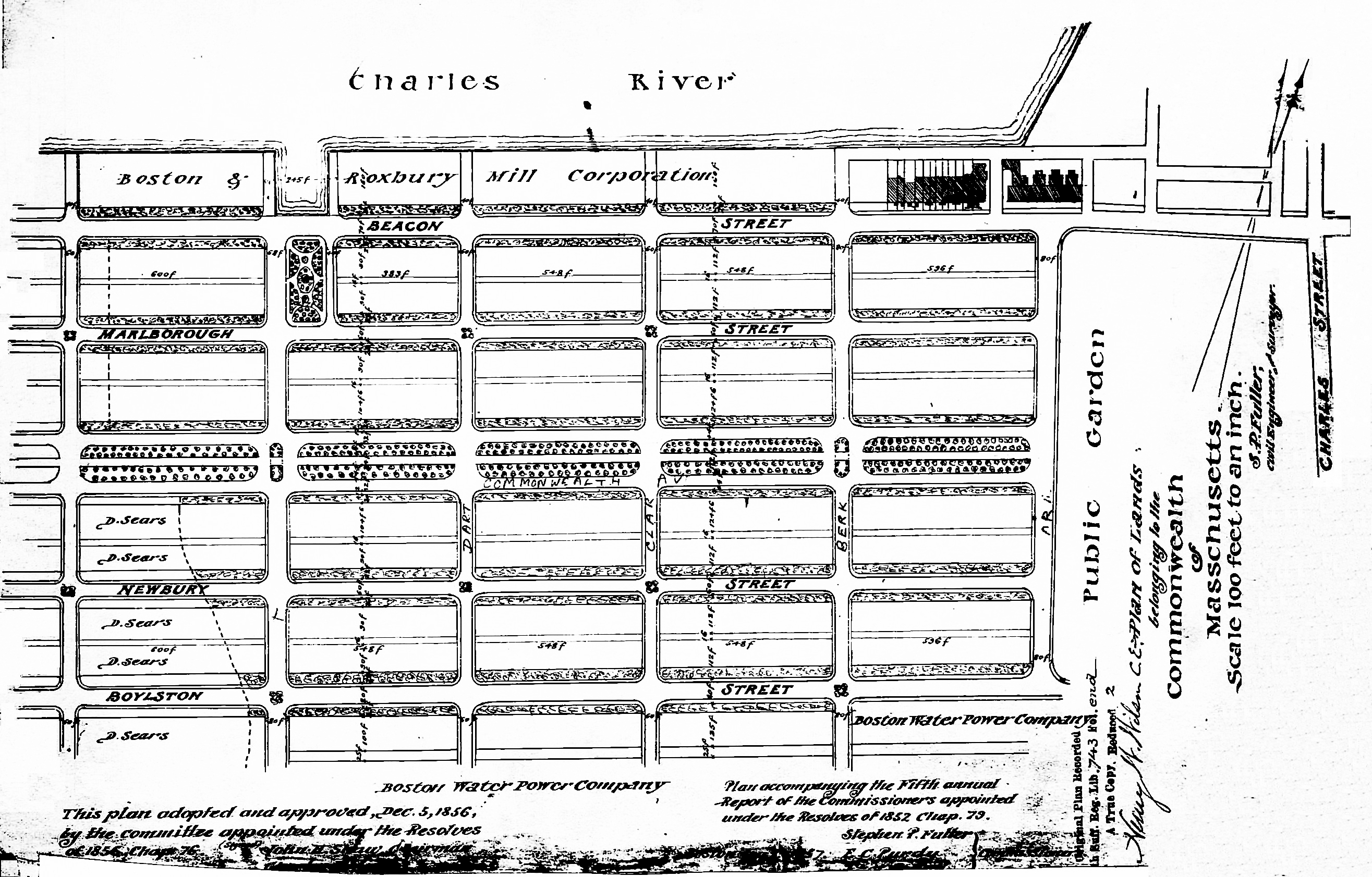
Plan of Commonwealth lands, 5Dec1856 (Suffolk Co. Deed Registry, Book 743, end of book)
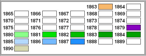
Commonwealth of Massachusetts Land. The Commonwealth sold its land starting in 1857. The earliest transactions were by private sales negotiated by the Commissioners on the Back Bay. In 1860, the legislature required that all future sales be made through public auctions. The first auction was held on October 24, 1860, and they continued until March of 1872, when they were suspended due to depressed real estate values. In 1879, the legislature authorized the Harbor and Land Commissioners (successors to the Commissioners on the Back Bay) to sell lots with frontages of up to 100 feet by privately negotiated sale. The land sales resumed in May of 1879 and the last of the remaining land was sold in 1886.
Click here for more information on the Commonwealth of Massachusetts land in the Back Bay.
The Commonwealth sold its land on the north side of Commonwealth between Exeter and Fairfield both at its last public auction, on May 20, 1879, and by privately-negotiated sales in 1879 and 1880.
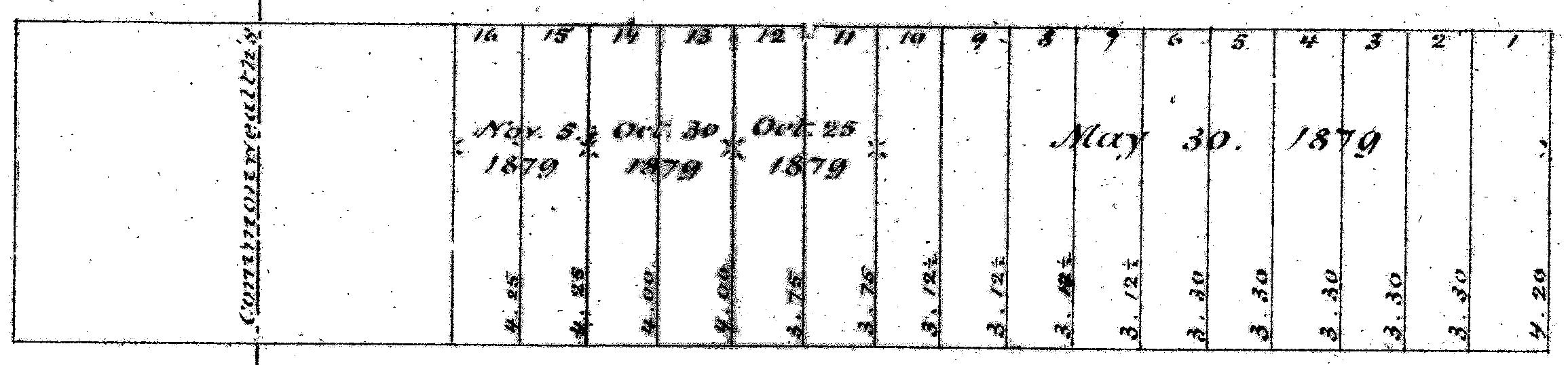
Excerpt from plan of land sales through 1879, showing price paid per s.f.; 1879 Harbor and Land Commissioners Report
The ten lots to the east were sold by the Commonwealth at its auction on May 20, 1879, the 30 foot corner lot at Exeter (Lot 1) and nine 26 foot lots (Lots 2-10). The Boston Herald and Boston Journal for May 21, 1879, reported that the corner lot and the five lots to its west (Lots 1-6) were purchased by real estate dealer John Jeffries, Jr., and that the next lot (Lot 7) was purchased by investment banker Henry C. Wainwright. Both papers reported that Lots 8-10 were purchased by Edward A. Robinson. The Journal further identified him as being of “Robinson & Dodge.” It would appear that this was Edwin (not Edward) Augustus Robinson, a flour merchant in partnership with William J. Dodge.
The Commonwealth sold its remaining land on the block by privately-negotiated agreements.
A plan accompanying the 1879 Harbor and Land Commissioners Report showed all of the land sales through 1879 (erroneously stating the date of the May 1879 auction as May 30 rather than May 20). The plan indicated that Lots 11 and 12 were sold on October 25, 1879, Lots 13 and 14 on October 30, 1879, and Lots 15 and 16 on November 5, 1879. Neither the map nor the report identifies the names of the purchasers, and there does not appear to have been a news account of their sale.
In their annual report for 1880, the Harbor and Land Commissioners reported that all of the remaining land on the north side of Commonwealth had been sold during that year. Again, the names of the purchasers were not given nor do they appear to have been reported in the press.
Boston Water Power Company Lands. The Boston Water Power Company sold its land in large parcels, almost exclusively to real estate investment trusts which then subdivided the land and resold it. It sold land in 1863, 1866, 1868, and 1872, by which point it had sold all of its land between the Commonwealth’s lands and a line 125 feet west of Massachusetts Avenue (West Chester Park). It sold the remainder of its land in the residential portion of the neighborhood in 1880.
Click here for more information on the Boston Water Power Company land in the Back Bay.
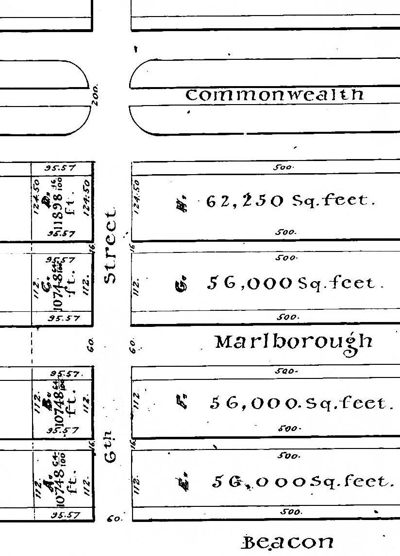
Detail from plan by J. F. Fuller, showing land purchased by Daniel Davies et al (Fairfield shown as “6th Street”); Suffolk Co. Deed Registry, Book 826, p. 87; 25Feb1863
On February 16, 1863, the Boston Water Power Company sold all of its land from the boundary with the Commonwealth to Fairfield on the south side of Beacon, north and south side of Marlborough, and north side of Commonwealth, to Daniel Davies, Jarvis D. Braman, and Grenville T. W. Braman.
Grenville Temple Winthrop Braman was a real estate investor and treasurer of the Boston Water Power Company, remaining in that position until mid-1869. Jarvis Dwight Braman was his brother. In the mid-1860s he was assistant paymaster for the Commonwealth, and by the 1870s he was engaged in real estate with his brother. In mid- to late-1878, he became President of the Boston Water Power Company, remaining in that position until his death in October of 1888. Daniel Davies was a housewright and master carpenter. His daughter, Susan (Susie) A. (Davies) Braman, was Grenville Braman’s wife.
Eastern Parcels. Real estate dealer John Jeffries, Jr., was the successful bidder at the May 20, 1879, auction for the six lots at the eastern end of the block, with a total frontage of 160 feet. He subsequently sold or transferred his right to purchase the land.
On May 9, 1881, the Commonwealth sold a 56 foot lot (originally Lots 1-2) at the corner of Exeter to Dr. Henry C. Haven, who sold the western half on May 19, 1881, to Thomas Rotch. Henry Haven built his home at 19 Exeter and a stable and carriage house on the alley, which later became 17 Exeter. Thomas Rotch built his home at 197 Commonwealth.
On April 30, 1886, the Commonwealth sold Lots 3-4, with a combined frontage of 52 feet, to the estate of Henry P. Kidder. On November 11, 1886, the estate sold the land to James Arthur Beebe, who built 199 Commonwealth as his home.
Central Parcels. Samuel Endicott Peabody acquired the rights to purchase Lots 5-7, each 26 feet wide, for which John Jeffries, Jr., and Henry C. Wainwright, had been the successful bidders at the May 20, 1879, auction. He built his home on Lot 6 at 205 Commonwealth and then took title from the Commonwealth to all three lots in March of 1883, after his home was completed. He sold Lot 7, to the west, that same month to a trust established for the benefit of Aimée (Rotch) Sargent, the wife of Winthrop Henry Sargent, and the Sargents built their home at 207 Commonwealth. He sold lot 5, to the east, on June 13, 1883, to Henry M. Whitney. Henry Whitney sold the land on September 18, 1883, to Leopold Morse, who built his home at 203 Commonwealth (there is no house numbered 201 Commonwealth).
E. A. Robinson had been the successful bidder at the May 20, 1879, auction for the three 26 foot lots to the west of 207 Commonwealth (Lots 8-10). He sold or transferred his rights to purchase the lots and on June 1, 1882, the Commonwealth sold the eastern two to William Powell Mason. He built his home at 211 Commonwealth (there is no house numbered 209 Commonwealth).
Sarah (Richardson) White, the wife of Charles Tallman White, acquired the right to purchase the lot to the west (Lot 10) and she and her husband built their home at 213 Commonwealth. On October 13, 1882, after the house had been completed, she took title to the land from the Commonwealth.
In September of 1882, the Commonwealth sold the two lots west of 213 Commonwealth, a 28 foot lot to the east and a 26 foot lot to the west, to James Lawrence. He built his home at 215 Commonwealth on the eastern lot.
On January 31, 1883, James Lawrence sold the 26 foot lot to the west to Miss Emily Esther Sears. The land remained vacant, and on May 22, 1886, she sold it to the Algonquin Club. On June 14, 1886, the Club purchased the 56 foot lot further west from investment banker Henry Lee, Jr. (who had purchased it from the Commonwealth on January 12, 1886). It combined the lots and built its clubhouse at 217 Commonwealth.
On November 27, 1880, the Commonwealth sold the two lots west of where the Algonquin Club later would be built to Henry Saltonstall. On April 10, 1883, he sold the eastern 26 foot lot to George Higginson, who built 223 Commonwealth (there are no houses numbered 219-221 Commonwealth) and, upon its completion, sold it to Charles Elliott Perkins. He and his wife, Edith (Forbes) Perkins made 223 Commonwealth their home.
On March 5, 1884, Nelson Slater Bartlett, as trustee under the will of his father, Matthew Bartlett, purchased the western 26 foot lot from Henry Saltonstall. On March 12, 1884, he purchased a 22 foot lot to the west from the Commonwealth, and on May 2, he sold the eastern 24 feet of the lot he had acquired from Henry Saltonstall to Dr. William L. Richardson. William Richardson built 225 Commonwealth as his home and Nelson Bartlett built 227 Commonwealth as the home of his widowed mother, Mary Eliza (Meads) Bartlett, and his unmarried sisters, Fannie Bartlett and Mary Foster Bartlett. Nelson S. Bartlett and his wife, Isabel Hazard (Bullock) Bartlett, lived across the alley at 272 Marlborough.
Two years earlier, on May 2, 1882, the Commonwealth had sold a 30 foot lot to the west of where 227 Commonwealth would be built to a trust established under the will of John Amory Lowell for the benefit of his daughter, Elizabeth (Lowell) Sprague, the wife of Dr. Francis Peleg Sprague. The Spragues built their home at 229 Commonwealth.
On March 13, 1884, the Commonwealth sold Jacob Crowninshield Rogers its land furthest west on the block, a 26.8 foot lot bounded on the west by the land formerly owned by the Boston Water Power Company. On January 18, 1886, he purchased the 27 foot lot further west from Frederick Sears Grand d’Hauteville. Jacob Rogers subsequently built 231 Commonwealth as his home on the former Commonwealth land, and 233 Commonwealth as the home of his brother, William C. Rogers, on the former Boston Water Power Company land.
Western Parcels. The Boston Water Power Company’s land changed hands several times between 1863 and 1884.
On February 16, 1863, the company had sold all of its land on the south side of Beacon between Exeter and Fairfield to Daniel Davies, Jarvis D. Braman, and Grenville T. W. Braman. The deed indicated that the parcel extended west 95.57 feet from the boundary with the lands owned by the Commonwealth to Fairfield. As noted above, this description was inconsistent with the Commonwealth’s deeds, which placed the boundary 95.20 feet east of Fairfield.
On December 30, 1868, Daniel Davies and his partners sold their parcels on the south side of Marlborough and the north side of Commonwealth to Henry N. F. Marshall, a dealer in paints, oils, and glass. On February 25, 1869, he sold both parcels to James C. White, and on June 29, 1869, James White sold both parcels to Dr. Horatio Robinson Storer, a physician.
On December 15, 1870, Horatio Storer sold the corner lot at Commonwealth and Fairfield, with a frontage on Commonwealth of 41.57 feet, to Sarah Olcott Murdoch (Blake) Whitmore, the wife of wholesale grocery merchant Charles John Whitmore. Dr. Storer retained the remaining 54 feet to the east, and January 6, 1877, he transferred it to a trust for the benefit of his wife, Frances Sophia (Mackenzie) Storer, and his children.
Sarah Whitmore sold the corner lot on August 6, 1877, to Ellen A. (Larrabee) Johnson, the wife of Henry M. Johnson, She sold the lot to Nathaniel Thayer, Jr., on November 22, 1880.
The trust established by Horatio Storer divided the 54 foot parcel into two 27 foot lots. It sold the western lot on April 3, 1878, to Daniel H. Lane, and the eastern lot on March 20, to Walter C. Cabot. The lots subsequently changed hands and were acquired by Frederick Sears Grand d’Hauteville, the western lot on February 11, 1881, and the eastern lot on March 21, 1881.
On April 30, 1881, Frederick Sears Grand d’Hauteville sold the western lot to Nathaniel Thayer, Jr., but reduced the width from 24 feet to 23.63 feet, thereby reconciling the discrepancy between the calculations reflected in the deeds from the Boston Water Power Company and the Commonwealth.
Nathaniel Thayer, Jr., combined the lot with his corner lot and sold the eastern 21 feet on October 4, 1882, to George Wheatland, Jr., who built his home at 235 Commonwealth. Nathaniel Thayer retained the corner lot, with a 47.2 foot frontage on Commonwealth, and built his home at 22 Fairfield (239 Commonwealth) (there is no house numbered 237 Commonwealth).
As noted above, Frederick Sears Grand d’Hauteville sold his eastern 27 foot lot on January 18, 1886, to Jacob C. Rogers, who also owned the land further east, and built 231 Commonwealth and 233 Commonwealth on the two lots.
Original Construction. All of the buildings on the north side of Commonwealth between Exeter and Fairfield had been built by 1890.
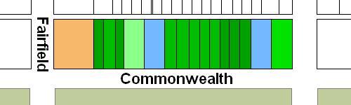
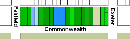
The plans below illustrate when the land on the block was first sold by the Commonwealth or the Boston Water Power Company, when the Commonwealth or Daniel Davies and his partners conveyed the land (based on the dates of the deeds), and when houses were first constructed (based on building permit applications, news reports, and dates provided in Bainbridge Bunting’s Houses of Boston’s Back Bay).
Original land sales on the north side of Commonwealth between Exeter and Fairfield
Original deeds conveying land on the north side of Commonwealth between Exeter and Fairfield
Original construction on the north side of Commonwealth between Exeter and Fairfield
Building Restrictions in Original Land Deeds
The deeds from the Commonwealth included identical language specifying that any building on the land was to be “at least three stories high for the main part thereof and shall not in any event be used for a stable, or for any mechanical, mercantile, or manufacturing purposes;” that the front walls were to be set back twenty feet from Commonwealth, with “steps, windows, porticos, and other usual projections appurtenant thereto” allowed in the reserved space subject to dimensional limitations enumerated in the deed; and that “no cellar or lower floor of any building shall be placed more than four feet below the level of the mill-dam, as fixed by the top surface of the hammered stone at the south-easterly corner of the emptying sluices.” The deed also provided that the owners of the land would have the right to “cultivate trees on the side walks” in front of their land provided that they left a distance of ten feet between the front boundary of their lots and the trees.
In November of 1858, the Commissioners on the Back Bay had voted to clarify that the prohibition on stables would not be enforced “in such a manner as to prevent the erection and use of private stables by gentlemen as appurtenances to their own dwelling homes; provided, such stables are so constructed and used as not to be justly offensive to the occupants of the surrounding buildings.” This clarification was subsequently published in the auction catalogues issued by the Commissioners, but usually was not included in the deeds.
The February 16, 1863, deed from the Boston Water Power Company to Daniel Davies and his partners included language almost identical to that of the Commonwealth’s deeds, with the exception that the height of the buildings was required to be “at least two stories high for the main part thereof exclusive of basement and attic” and the prohibition against stables was clarified as being a prohibition against “livery stables.”
Click here for more information on the restrictions contained in deeds of Back Bay land.
Original Land Deeds
The Commonwealth of Massachusetts conveyed the land on the north side of Commonwealth between Exeter and Fairfield by the following deeds:
| Address | Date | E-W | N-S | Grantee | Book | Page |
| 17-19 Exeter 197 Commonwealth |
09May1881 | 56’ | 124.5’ | Henry C. Haven | 1525 | 65 |
| 199 Commonwealth | 30Apr1886 | 52’ | 124.5’ | Samuel S. Shaw, Charles A. Kidder, and Oliver W. Peabody, trustees for the residual devisees of Henry P. Kidder | 1723 | 597 |
| 203 Commonwealth | 20Mar1883 | 26’ | 124.5’ | Samuel Endicott Peabody | 1592 | 26 |
| 205 Commonwealth | 20Mar1883 | 26’ | 124.5’ | Samuel Endicott Peabody | 1592 | 29 |
| 207 Commonwealth | 13Mar1883 | 26’ | 124.5’ | Samuel Endicott Peabody | 1591 | 3 |
| 211 Commonwealth | 01Jun1882 | 26’ | 124.5’ | William Powell Mason | 1566 | 465 |
| 211 Commonwealth | 01Jun1882 | 26’ | 124.5’ | William Powell Mason | 1566 | 468 |
| 213 Commonwealth | 13Oct1882 | 26’ | 124.5’ | Sarah B. White, wife of Charles T. White | 1577 | 274 |
| 215 Commonwealth | 11Sep1882 | 28’ | 124.5’ | James Lawrence | 1572 | 549 |
| 217 Commonwealth | 04Sep1882 | 26’ | 124.5’ | James Lawrence | 1571 | 417 |
| 217 Commonwealth | 12Jan1886 | 56’ | 124.5’ | Henry Lee | 1709 | 104 |
| 223-227 Commonwealth | 27Nov1880 | 52’ | 124.5’ | Henry Saltonstall | 1510 | 385 |
| 227 Commonwealth | 12Mar1884 | 22’ | 124.5’ | Nelson S. Bartlett, trustee under the will of Matthew Bartlett | 1630 | 503 |
| 229 Commonwealth | 02May1882 | 30’ | 124.5’ | John Lowell and Augustus Lowell, trustees under the will of John Amory Lowell | 1619 | 97 |
| 231 Commonwealth | 13Mar1884 | 26.8 | 124.5’ | Jacob C. Rogers | 1630 | 551 |
The Boston Water Power Company conveyed the land on the north side of Commonwealth between Exeter and Fairfield by the following deed:
| Address | Date | E-W | N-S | Grantee | Book | Page |
| 233-235-239 Commonwealth | 16Feb1863 | 95.57’ | 112’ | Daniel Davies, Jarvis D. Braman, and Grenville T. W. Braman | 826 | 86 |
Daniel Davies, Jarvis Braman, and Grenville T. W. Braman conveyed the land on the north side of Commonwealth between Exeter and Fairfield by the following deed:
| Address | Date | E-W | N-S | Grantee | Book | Page |
| 233-235-239 Commonwealth | 30Dec1868 | 95.57’ | 112’ | Henry N. F. Marshall | 948 | 185 |
