The block on the south side of Commonwealth between Hereford and Massachusetts Avenue (formerly West Chester Park) is 640 feet in length and 124 feet 6 inches from Commonwealth to Alley 430.
The original land was divided between the Boston Water Power Company, which owned the land to the west, and the David Sears family, which owned the land to the east. The boundary between the parcels ran southwest at approximately a 45 degree angle from a point on the south side of Commonwealth 134.66 feet west of Hereford (324 Commonwealth straddles the line). The boundary was parallel to Parker Street (above the Cross Dam) further west, which crossed, at an angle, the intersection of Commonwealth and Massachusetts Avenue.
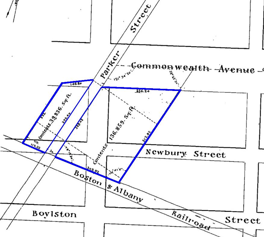
Detail from plan by J. F. Fuller showing lands purchased by David Skillings on 19Apr1870; Suffolk County Deed Registry, Book 997, p. 73 (color added)
The land ran from the south side of Commonwealth to the north side of Newbury, including the area which later would become Alley 430.
Boston Water Power Company Land. The Boston Water Power Company sold its land in 1870, in two transactions, to lumber dealer David Nelson Skillings of Winchester as trustee of a real estate investment trust composed of himself, Lawrence Barnes of Burlington, Vermont, Charles Whitney of Lowell, and David Whitney, Jr. of Detroit.
David Skillings’s first purchase was on April 19, 1870, when he acquired a parcel on the east side of Parker Street with a frontage on Commonwealth of 327.56 feet. At the same time, he also purchased a smaller parcel on the west side of Parker Street.
David Skillings’s second purchase was on December 16, 1870, when he acquired the land to the east of the first parcel, with a frontage on 177.44 feet Commonwealth, running to the Sears family land. The combined tract had a frontage of 505 feet on Commonwealth.
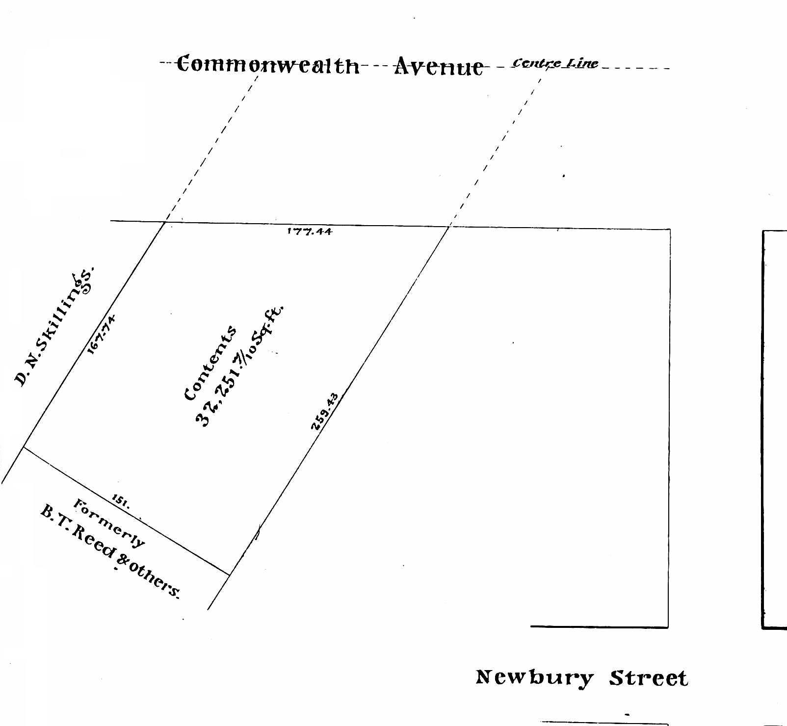
Detail from plan by J. F. Fuller showing lands purchased by David Skillings on 16Dec1870; Suffolk Co, Deed Registry, Book 1032, p. 98
On May 3, 1873, David Skillings, as trustee, sold the land to Horace M. Bearce and Ira T. Drew, who entered into a mortgage with the trust to finance the purchase. On January 5, 1878, David Skillings, on behalf of the trust, foreclosed on the mortgage and sold the property at public auction. It was purchased by his son, David N. Skillings, Jr., who then transferred it to his father on January 12, 1878. Through these transactions, the trust received the auction value of the property and David Skillings became the sole owner.
On February 7, 1878, David Skillings acquired the road bed and land for Parker Street that previously had divided the eastern portion of his land (Parker Street had been discontinued as a public thoroughfare between Beacon and Boylston the previous year).
Click here for more information on the Boston Water Power Company land in the Back Bay.
Sears Family Land. The David Sears family land extended south from a line down the middle of Commonwealth, bounded on the east by the Commonwealth’s lands at a point 262 feet west of Exeter (at about the western wall of 214 Commonwealth), and on the west by the Boston Water Power Company’s lands. The Sears family land extended south by an irregular line past Boylston to about St. James Street.
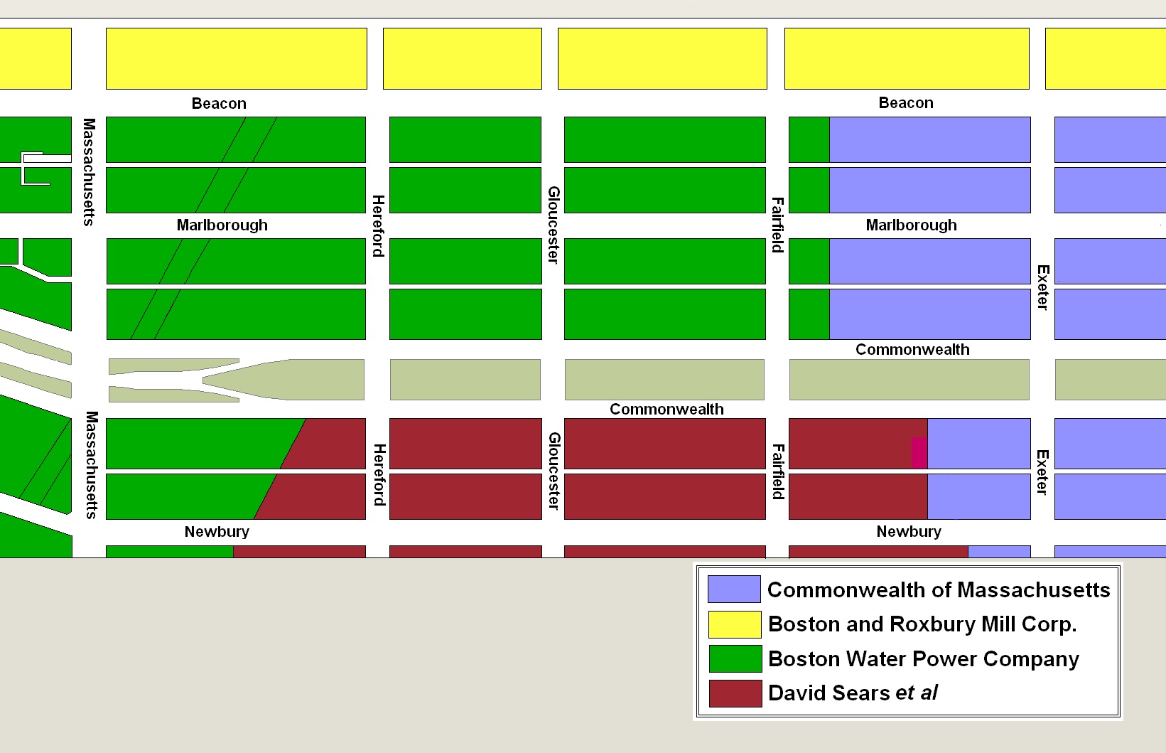
Original owners of land in the residential portion of the Back Bay
The Sears family sold all of its land on January 2, 1871, to Nathan Matthews. He was a real estate investor and developer, and served as president of the Boston Water Power Company from 1860 to 1870. He and his wife, Albertine (Bunker) Matthews, lived at 12 Arlington.
In January and February of 1871, Nathan Matthews sold David Skillings (in his capacity as trustee of the trust formed with Lawrence Barnes, Charles Whitney, and David Whitney, Jr.) all of his land between the south side of Commonwealth and the north side of Newbury, bounded on the east by the boundary with the Commonwealth’s land and on the west by the boundary with the Boston Water Power Company’s land.
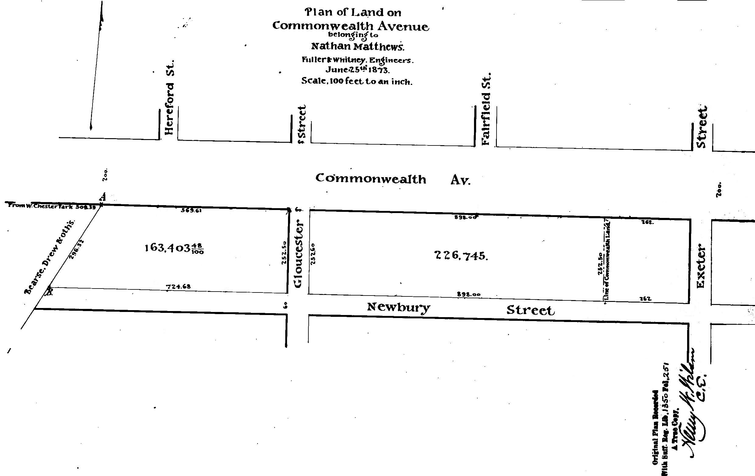
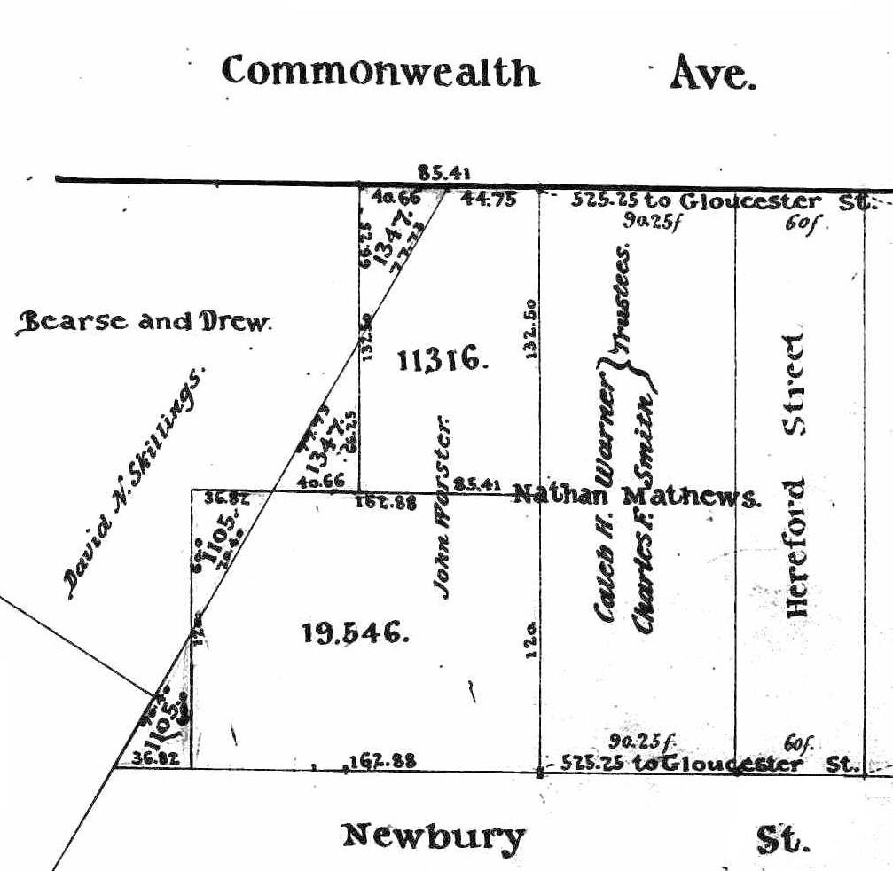
Plan of Land owned by Nathan Matthews; by Fuller & Whitney, 25Jun1873 (Suffolk Co. Deed Registry, Book 1350, p. 251).
On May 30, 1873, David N. Skillings sold the land back to Nathan Matthews. As shown on the plan to the left, the land included the 60 foot wide parcels where Fairfield and Hereford Streets later would be located.
On October 16, 1873, Nathan Matthews conveyed the land to real estate investment trust he had formed with Henry D. Hyde and Grenville T. W. Braman.
Henry Dwight Hyde was an attorney. He and his wife, Luvan Augusta (Charles) Hyde, lived at 153 West Newton and later at 380 Commonwealth. Grenville Temple Winthrop Braman was a real estate investor and served as treasurer of the Boston Water Power Company until mid-1869 (at the same time as Nathan Matthews was president). He and his wife, Susie A. (Davies) Braman, lived at 9 Brimmer and later at 447 Beacon.
On November 19, 1875, Nathan Matthews and his partners terminated the trust and conveyed the land to individual owners.
Nathan Matthews was conveyed the land between Gloucester and the boundary with the Boston Water Power Company. The parcel ran between the south side of Commonwealth and the north side of Newbury (including the land where the alleys later would be laid out and the 60 foot wide parcel where Hereford Street later would be located). The parcel had a frontage of 569.61 feet on the south side Commonwealth and 724.68 feet on the north side of Newbury.
On June 2, 1876, Nathan Matthews subdivided the parcel. He sold the lot at the corner of Gloucester, with a frontage on Commonwealth and Newbury of 74.75 feet, to the Boylston National Bank, the lot west of it, with a frontage of 38 feet 7½ inches, to Edwin Pope, and the parcel to the west of that, with a frontage of 411 feet 10½ inches, to Caleb H. Warner and Charles F. Smith. The parcel purchased by Caleb Warner and Charles Smith included the western 261 feet 7½ inches of the block between Gloucester and Hereford, the 60 foot wide parcel where Hereford Street later would be located, and eastern 90 feet 3 inches of the block between Hereford and Massachusetts Avenue.
Nathan Matthews retained the land furthest west, between the land he sold to Caleb Warner and Charles Smith and the boundary with the Boston Water Power Company lands.
All of the land sold by Nathan Matthews on June 2, 1876, and the parcel he retained, were subject to a mortgage held by David Skillings. On October 21, 1876, he foreclosed on the mortgage and sold his interest in the property to Albert J. Fernald.
That same month, Albert Fernald sold the Boylston National Bank and Edwin Pope his interest in the parcels they had purchased from Nathan Matthews, and sold Edwin Tufts his interest in the land that Caleb Warner and Charles Smith had purchased from Nathan Matthews (on January 4, 1877, Edwin Tufts conveyed his interest to Caleb Warner and Charles Smith).
Albert Fernald sold the land that had been retained by Nathan Matthews to John Worster.
Click here for more information on the Sears family land in the Back Bay.
As of February of 1878, the former Sears family lands on the south side of Commonwealth and north side of Newbury between Hereford and Massachusetts were owned by Caleb Warner and Charles Smith, and by John Worster; the former Boston Water Power Company lands were owned by David Skillings.
Detail from plan by Henry W. Wilson showing triangular lots exchanged between David Skillings and John Worster on 17Dec1878; Suffolk Co, Deed Registry, Book 1443, p. 190
The boundary between John Worster’s land and David Skillings’s land ran at an angle, and on December 17, 1878, David Skillings and John Worster exchanged triangular shaped lots to “square off” their respective holdings so that the north-south boundary ran in a straight line rather than at an angle, creating rectangular lots on both Commonwealth and Newbury. The boundary of the triangular lot on Commonwealth was 40.66 feet wide and, when combined with John Worster’s other land, created a rectangular lot 85.41 feet wide. David Skillings’s remaining land on Commonwealth had a frontage of 464.34 feet.
Eastern Parcels. Caleb Warner and Charles Smith sold the 28 foot lot at the southwest corner of Commonwealth and Hereford on April 1, 1879, to Sumner Mead, and on the same day they sold the remaining 62.25 foot lot to the west to Frank N. Thayer and William H. Lincoln.
On October 23, 1879, Frank Thayer and William Lincoln purchased the western 13.41 feet of John Worster’s lot, leaving him with a 72 foot wide lot. Frank Thayer purchased Sumner Mead’s corner lot on November 1, 1879. On March 21, 1881, Frank Thayer and William Lincoln sold the western 48 feet of their land to John W. Shapleigh, who built 318-320 Commonwealth on it. On the same day, Frank Thayer acquired William Lincoln’s interest in the remainder of the land. He built 316 Commonwealth on it, leaving the corner lot vacant (316 Commonwealth subsequently was razed and 314 Commonwealth was built on the vacant lot and on the lot where 316 Commonwealth had been located).
John Worster sold his remaining lot, with a 72 foot frontage, on April 19, 1880, to George Wheatland, Jr., who built 322-324-326 Commonwealth on the land.
David Skillings sold his land in the central and western portions of the block between December of 1878 and January of 1880.
Central Parcels. On October 11, 1879, David Skillings sold a 49.34 foot lot to the west of John Worster’s land to Henry P. Walcott, who sold the lot to Miss Elizabeth F. Brigham on February 11, 1886. She sold the land on February 23, 1886, to woolen manufacturer James S. Gill. He and his wife, Rachel M. (Wood) Gill, lived at the Hotel Kempton at 237 Berkeley and then at 374 Newbury.
James Gill built 330 Commonwealth on the western 24.67 feet of the lot and, on September 27, 1888, he sold the completed house to Mary A. (Watson) Ferguson, the wife of Robert Ferguson. They made it their home.
On November 7, 1888, James Gill sold the vacant 24.67 foot lot to the east to Isaac Edmands, who built his home at 328 Commonwealth,
On December 13, 1878, David Skillings sold the 24 foot lot to the west of where 330 Commonwealth would be built to Elizabeth W. (Shute) Fitch, the wife of Benjamin Fitch. They built their home at 332 Commonwealth.
On October 15, 1879, David Skillings sold the 24 foot lot to the west of Elizabeth Fitch’s land to William Noble, who built his home at 334 Commonwealth.
On October 25, 1879, David Skillings sold a 50 foot parcel west of the lot he sold to William Noble to Charles Merriam, and on January 19, 1880, he sold a 231 foot parcel to the west of it to Jacob Crowninshield Rogers.
Building contractor George Wheatland, Jr., entered into agreements with Charles Merriam and Jacob Rogers under which he constructed thirteen houses on their land at 336-338-340-342-344-346-348-350-352-354-356-358-360 Commonwealth. As they were completed, George Wheatland, Jr., purchased the land and houses, and then resold them to individual buyers.
Western Parcels. On March 5, 1879, David Skillings sold a 32 foot lot at the corner of Massachusetts Avenue to Frederic Amory and a 28 foot lot to the east of it to Harcourt Amory, and on March 10, 1879, he sold a 26 foot lot to the west of that to Harcourt Amory.
On April 21, 1881, the Amorys sold their land to Melancthon Woolsey Borland. He sold the western one foot on December 4, 1883, to George Wheatland, Jr., who combined it with a 20 foot lot he acquired from Jacob Rogers and built 360 Commonwealth on it. M. Woolsey Borland subdivided the remaining 85 feet into a 30 foot lot on the corner and a 55 foot lot to the east. He sold the corner lot to Luther D. Shepard on December 1, 1885, and the 55 foot lot on February 8, 1886, to James S. Gill. The 55 foot lot subsequently changed hands and was purchased by building contractor Silas Whiton Merrill on February 28, 1889.
On August 7, 1899, Thomas R. White, a mason, purchased the 30 foot corner lot from Luther D. Shepard, and on September 20, 1899, he purchased the 55 foot lot to the east from Silas W. Merrill. He built a six unit apartment house at 362 Commonwealth and a ten unit apartment house at 364-366 Commonwealth.
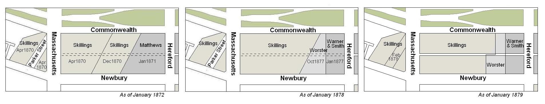
Evolution of the early land ownership on the south side of Commonwealth between Hereford and Massachusetts Avenue.
Building Restrictions in Original Land Deeds
Neither of the deeds from the Boston Water Power Company to David Skillings included any building restrictions, nor did the Sears Family deed to Nathan Matthews.
On December 7, 1878, David Skillings, John Worster, and Caleb H. Warner and Charles F. Smith, trustees, as owners of all of the land between Hereford and Massachusetts Avenue and between Commonwealth and Newbury, entered into an agreement (Book 1443, p. 145) establishing a uniform setback requirement comparable to the restrictions contained in the deeds from Commonwealth of Massachusetts conveying its lands on Commonwealth. The agreement specified that buildings were to be set back twenty feet from Commonwealth, but provided that doors, porticos, windows, and roof cornices were allowed to project into the reserved space with depth and dimensional limitations similar to those required by the Commonwealth deeds (as expanded upon by the regulations of the Commissioners on Public Lands). No setback requirement was established for Newbury.
The agreement also provided for the establishment of a sixteen foot wide passageway between Commonwealth and Newbury (later Alley 430).
The agreement did not include any of the other restrictions often included in deeds for Back Bay lands, such as language specifying that the buildings must be built of brick, stone, or iron; must be of a minimum height; and may not be used for livery stables nor for mechanical or manufacturing purposes.
Click here for more information on the restrictions contained in deeds of Back Bay land.
Original Land Deeds
The Boston Water Power Company sold its land on the south side of Commonwealth between Hereford and Massachusetts Avenue by the following deeds:
| Address | Date | Frontage on Commonwealth | Grantee | Book | Page |
| 324-338 Commonwealth | 16Dec1870 | 177.44’ | David N. Skillings, trustee, for himself, Lawrence Barnes, Charles Whitney, and David Whitney, Jr. | 1032 | 98 |
| 338-362 Commonwealth | 19Apr1870 | 327.9’ | David N. Skillings, trustee, for himself, Lawrence Barnes, Charles Whitney, and David Whitney, Jr. | 997 | 73 |
On January 2, 1871, the Sears family sold all of its land the Nathan Matthews (Book 1029, p. 233), including land on the south side of Commonwealth bounded on the east by the Commonwealth’s lands at a point 262 feet west of Exeter and bounded on the west by the Boston Water Power Company’s lands by a line that ran southwest at approximately a 45 degree angle, starting at a point on the south side of Commonwealth 134.66 feet west of Hereford. The land extended south by an irregular line past Boylston to about St. James Street.
On the same day Nathan Matthews conveyed to Franklin Evans the land on the south side of Commonwealth and north side of Newbury from the boundary with the Commonwealth’s lands to Fairfield (Book 1029, p. 239); and conveyed to David N. Skillings, trustee, the land on the south side of Commonwealth and the north side of Newbury from Fairfield to the boundary with the Boston Water Power Company’s lands (Book 1029, p. 238). On February 8, 1871, Franklin Haven conveyed the land east of Fairfield back to Nathan Matthews (Book 1034, p. 56), and Nathan Matthews transferred it to David N. Skillings, trustee (Book 1034, p. 84).
On May 30, 1873, David N. Skillings sold all of the land he previously purchased from Nathan Matthews back to him (Book 1163, p. 259). On October 16, 1873, Nathan Matthews transferred the land to attorney Harvey N. Shepard (Book 1182, p. 270) who conveyed it on the same day to Nathan Matthews, Henry D. Hyde, and Grenville T. W. Braman, as trustees of a real estate investment trust (Book 1182, p. 271).
On November 19, 1875, the trustees terminated the trust and transferred the land back to Harvey N. Shepard (Book 1303, p. 157). On the same day, Harvey Shepard conveyed the land to individual owners, including conveying the land between Gloucester and the boundary with the Boston Water Power Company’s lands to Nathan Matthews (Book 1303, p. 307).
On June 2, 1876, Nathan Matthews sold Caleb H. Warner and Charles F. Smith a parcel including the eastern 90 feet 3 inches of the block between Hereford and Massachusetts Avenue (Book 1329, p. 63). The parcel also included the western 261 feet 7½ inches of the block between Gloucester, and Hereford and the 60 foot wide parcel where Hereford Street later would be located. Nathan Matthews retained the land further west, between the land he conveyed to Caleb Warner and Charles Smith and the boundary with the Boston Water Power Company’s lands.
On October 21, 1876, David Skillings foreclosed on a mortgage which included both the land Nathan Matthews had sold to Caleb Warner and Charles Smith, and the land Nathan Matthews had retained. David Skillings sold the land to Albert J. Fernald (Book 1350, p. 250). Albert Fernald sold Edwin Tufts his interest in the land previously purchased by Caleb Warner and Charles Smith (Book 1360, p. 188) and sold the land retained by Nathan Matthews to John Worster (Book 1396, p. 196). On January 4, 1877, Edwin Tufts sold the land back to Caleb Warner and Charles Smith (Book 1362, p. 133).
